The Precambrian is the earliest part of Earth's history, set before the current Phanerozoic Eon. The Precambrian is so named because it preceded the Cambrian, the first period of the Phanerozoic eon, which is named after Cambria, the Latinised name for Wales, where rocks from this age were first studied. The Precambrian accounts for 88% of the Earth's geologic time.

A geologic map or geological map is a special-purpose map made to show geological features. Rock units or geologic strata are shown by color or symbols to indicate where they are exposed at the surface. Bedding planes and structural features such as faults, folds, foliations, and lineations are shown with strike and dip or trend and plunge symbols which give these features' three-dimensional orientations.

The Morrison Formation is a distinctive sequence of Upper Jurassic sedimentary rock found in the western United States which has been the most fertile source of dinosaur fossils in North America. It is composed of mudstone, sandstone, siltstone, and limestone and is light gray, greenish gray, or red. Most of the fossils occur in the green siltstone beds and lower sandstones, relics of the rivers and floodplains of the Jurassic period.
The ASEAN Declaration or Bangkok Declaration is the founding document of Association of Southeast Asian Nations (ASEAN). It was signed in Bangkok on 8 August 1967 by the five ASEAN founding members, Indonesia, Malaysia, Philippines, Singapore, and Thailand as a display of solidarity against communist expansion in Vietnam and communist insurgency within their own borders. It states the basic principles of ASEAN: co-operation, amity, and non-interference. The date is now celebrated as ASEAN Day.
The Maastrichtian is, in the ICS geologic timescale, the latest age of the Late Cretaceous epoch or Upper Cretaceous series, the Cretaceous period or system, and of the Mesozoic era or erathem. It spanned the interval from 72.1 to 66 million years ago. The Maastrichtian was preceded by the Campanian and succeeded by the Danian.

Huaxiagnathus is a genus of theropod dinosaur from the Lower Cretaceous of China. It was a compsognathid, large for that group at about half a meter longer than Compsognathus and larger specimens of Sinosauropteryx, with the largest specimen about 1.8 meters in length.
The Barun Goyot Formation is a geological formation dating to the Late Cretaceous Period. It is located within and is widely represented in the Gobi Desert Basin, in the Ömnögovi Province of Mongolia.

The Laramie Formation is a geologic formation of Late Cretaceous (Maastrichtian) age, named by Clarence King in 1876 for exposures in northeastern Colorado, in the United States. It was deposited on a coastal plain and in coastal swamps that flanked the Western Interior Seaway. It contains coal, clay and uranium deposits, as well as plant and animal fossils, including dinosaur remains.

The Cedar Mountain Formation is the name given to a distinctive sedimentary geologic formation in eastern Utah. The formation was named for Cedar Mountain in northern Emery County, Utah, where William Lee Stokes first studied the exposures in 1944.

The Cloverly Formation is a geological formation of Early Cretaceous age that is present in parts of Montana, Wyoming, Colorado and Utah in the western United States. It was named for a post office on the eastern side of the Bighorn Basin in Wyoming by N.H. Darton in 1904. The sedimentary rocks of formation were deposited in floodplain environments and contain vertebrate fossils, including a diverse assemblage of dinosaur remains. In 1973, the Cloverly Formation Site was designated as a National Natural Landmark by the National Park Service.

Harmakhis Vallis is a valley near Hellas Planitia, Mars. It has been identified as an outflow channel, the site of catastrophic floods of water during Mars' past.

The Pierre Shale is a geologic formation or series in the Upper Cretaceous which occurs east of the Rocky Mountains in the Great Plains, from Pembina Valley in Canada to New Mexico.
The Milk River Formation is a near- shore to terrestrial sedimentary unit deposited during the Late Cretaceous in southern Alberta. It is equivalent to the marine Lea Park Formation of eastern Alberta, and the Eagle and Telegraph Creek Formations of north-central Montana, and to the upper part of the Niobrara Formation in Kansas.
The Denver Formation is a geological formation that is present within the central part of the Denver Basin that underlies the Denver, Colorado, area. It ranges in age from latest Cretaceous (Maastrichtian) to early Paleocene, and includes sediments that were deposited before, during and after the Cretaceous-Paleogene boundary event.

Frances Elizabeth Somerville Alexander was a British geologist, academic, and physicist, whose wartime work with radar and radio led to early developments in radio astronomy and whose post-war work on the geology of Singapore is considered a significant foundation to contemporary research. Alexander earned her PhD from Newnham College, Cambridge, and worked in Radio Direction Finding at Singapore Naval Base from 1938 to 1941. In January 1941, unable to return to Singapore from New Zealand, she became Head of Operations Research in New Zealand's Radio Development Lab, Wellington. In 1945, Alexander correctly interpreted that anomalous radar signals picked up on Norfolk Island were caused by the sun. This interpretation became pioneering work in the field of radio astronomy, making her one of the first women scientists to work in that field, albeit briefly.

The Casselman Formation mapped sedimentary bedrock unit in Pennsylvania, Maryland, and West Virginia, of Pennsylvanian age. It is the uppermost of two formations in the Conemaugh Group, the lower being the Glenshaw Formation. The boundary between these two units is the top of the marine Ames Limestone. The Conemaugh Group overlies the Upper Freeport coal bed of the Allegheny Formation and underlies the Pittsburgh coal seam of the Monongahela Group.
The Glenshaw Formation is a mapped sedimentary bedrock unit in Pennsylvania, Maryland, West Virginia, and Ohio, of Pennsylvanian age. It is the lower of two formations in the Conemaugh Group, the upper being the Casselman Formation. The boundary between these two units is the top of the marine Ames Limestone. The Conemaugh Group overlies the Upper Freeport coal bed of the Allegheny Formation and underlies the Pittsburgh coal seam of the Monongahela Group.
The geological history of Mars employs observations, indirect and direct measurements, and various inference techniques to estimate the physical evolution of Mars. Methods dating back to 17th century techniques developed by Nicholas Steno, including the so-called law of superposition and stratigraphy, used to estimate the geological histories of Earth and the Moon, are being actively applied to the data available from several Martian observational and measurement resources. These include the landers, orbiting platforms, Earth-based observations, and Martian meteorites.

The Brassfield Formation, named by A.F. Foerste in 1906, is a limestone and dolomite formation exposed in Arkansas, Ohio, Kentucky, Indiana, Tennessee and West Virginia in the United States. It is Early Silurian in age and well known for its abundant echinoderms, corals and stromatoporoids. In Ohio, where the unit has escaped dolomitization, the Brassfield is an encrinite biosparite with numerous crinoid species.
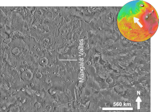
Mangala Fossa is a graben in the Memnonia quadrangle of Mars, located near 11.6°S 151.0°W, which originated in the Hesperian and Amazonian epochs. The graben is located at the head of the outflow channel Mangala Valles, which is thought to have been formed by at least two catastrophic flood events during the same geological period, leading to the release of vast quantities of water from Mangala Fossa onto the Martian surface. The flooding was probably initiated by the emplacement of a dike radiating from the volcano Arsia Mons, resulting in the formation of the graben, Mangala Fossa, at the channels' head. This dike breached a pressurized aquifer trapped beneath a thick "cryosphere" beneath the surface. As the floor of the graben subsided, water found its way up one or both of the faults in the crust that defined the edges of the graben and spilled into the depression, eventually filling it and overflowing at the lowest point on the rim to erode the Mangala Valles channels.

