Related Research Articles

Karst is a topography formed from the dissolution of soluble rocks such as limestone, dolomite, and gypsum. It is characterized by underground drainage systems with sinkholes and caves. It has also been documented for more weathering-resistant rocks, such as quartzite, given the right conditions. Subterranean drainage may limit surface water, with few to no rivers or lakes. However, in regions where the dissolved bedrock is covered or confined by one or more superimposed non-soluble rock strata, distinctive karst features may occur only at subsurface levels and can be totally missing above ground.

Limestone is a common type of carbonate sedimentary rock. It is composed mostly of the minerals calcite and aragonite, which are different crystal forms of calcium carbonate. Limestone forms when these minerals precipitate out of water containing dissolved calcium. This can take place through both biological and nonbiological processes, though biological processes have likely been more important for the last 540 million years. Limestone often contains fossils, and these provide scientists with information on ancient environments and on the evolution of life.

Chalk is a soft, white, porous, sedimentary carbonate rock. It is a form of limestone composed of the mineral calcite and originally formed deep under the sea by the compression of microscopic plankton that had settled to the sea floor. Chalk is common throughout Western Europe, where deposits underlie parts of France, and steep cliffs are often seen where they meet the sea in places such as the Dover cliffs on the Kent coast of the English Channel.

The Pennyroyal Plateau is a large area of Kentucky that features rolling hills, caves, and karst topography in general. It is named for a wild mint that grows in the area. It is also called the "Mississippian Plateau," for the Mississippian geologic age in which it was formed.

The Llano Uplift is a geologically ancient, low geologic dome that is about 90 miles (140 km) in diameter and located mostly in Llano, Mason, San Saba, Gillespie, and Blanco counties, Texas. It consists of an island-like exposure of Precambrian igneous and metamorphic rocks surrounded by outcrops of Paleozoic and Cretaceous sedimentary strata. At their widest, the exposed Precambrian rocks extend about 65 miles (105 km) westward from the valley of the Colorado River and beneath a broad, gentle topographic basin drained by the Llano River. The subdued topographic basin is underlain by Precambrian rocks and bordered by a discontinuous rim of flat-topped hills. These hills are the dissected edge of the Edwards Plateau, which consist of overlying Cretaceous sedimentary strata. Within this basin and along its margin are down-faulted blocks and erosional remnants of Paleozoic strata which form prominent hills.
The Nashville Basin, also known as the Central Basin, is a term often used to describe the area surrounding Murfreesboro, Tennessee, in which Nashville is located. The Central Basin was caused by an uplifting which produced a dome known as the Nashville Dome. The Nashville Dome is evidenced by the underlying rock strata that all dip downwards away from Nashville. The uplifting of the Nashville Dome fractured overlying strata, making it more easily eroded and thus the "dome" resulted in a "basin". Uplifted strata in the center of a geological dome have higher potential erosive energy than the surrounding strata, because they are physically higher. Erosion thus acts on the uplifted area at a greater rate than on the surrounding flat-lying area, creating a low area, i.e. a basin. This area is more correctly referred to as the "Central Dome" of Tennessee.
The Highland Rim is a geographic term for the area in Tennessee surrounding the Central Basin. Nashville is largely surrounded by higher terrain in all directions.

Dolomite (also known as dolomite rock, dolostone or dolomitic rock) is a sedimentary carbonate rock that contains a high percentage of the mineral dolomite, CaMg(CO3)2. It occurs widely, often in association with limestone and evaporites, though it is less abundant than limestone and rare in Cenozoic rock beds (beds less than about 65 million years in age). The first geologist to distinguish dolomite rock from limestone was Belsazar Hacquet in 1778.

The Central Eastern Alps, also referred to as Austrian Central Alps or just Central Alps, comprise the main chain of the Eastern Alps in Austria and the adjacent regions of Switzerland, Liechtenstein, Italy and Slovenia. South them is the Southern Limestone Alps.

Carboniferous Limestone is a collective term for the succession of limestones occurring widely throughout Great Britain and Ireland that were deposited during the Dinantian Epoch of the Carboniferous Period. These rocks formed between 363 and 325 million years ago. Within England and Wales, the entire limestone succession, which includes subordinate mudstones and some thin sandstones, is known as the Carboniferous Limestone Supergroup.

The Kaibab Limestone is a resistant cliff-forming, Permian geologic formation that crops out across the U.S. states of northern Arizona, southern Utah, east central Nevada and southeast California. It is also known as the Kaibab Formation in Arizona, Nevada, and Utah. The Kaibab Limestone forms the rim of the Grand Canyon. In the Big Maria Mountains, California, the Kaibab Limestone is highly metamorphosed and known as the Kaibab Marble.

The Ste. Genevieve Limestone is a geologic formation named for Ste. Genevieve, Missouri where it is exposed and was first described. It is a thick-bedded limestone that overlies the St. Louis Limestone. Both are Mississippian in age. The St. Louis Limestone is Meramecian and the Ste. Genevieve is the base of the Chesterian series.

Coral rag is a rubbly limestone composed of ancient coral reef material. The term also refers to the building blocks quarried from these strata, which are an important local building material in areas such as the coast of East Africa and the southeastern United States littoral.

The San Juan Basin is a geologic structural basin located near the Four Corners region of the Southwestern United States. The basin covers 7,500 square miles and resides in northwestern New Mexico, southwestern Colorado, and parts of Utah and Arizona. Specifically, the basin occupies space in the San Juan, Rio Arriba, Sandoval, and McKinley counties in New Mexico, and La Plata and Archuleta counties in Colorado. The basin extends roughly 100 miles (160 km) N-S and 90 miles (140 km) E-W.

The Magnesian Limestone is a suite of carbonate rocks in north-east England dating from the Permian period. The outcrop stretches from Nottingham northwards through Yorkshire and into County Durham where it is exposed along the coast between Hartlepool and South Shields. The term has now been discontinued in formal use though it appears widely in popular and scientific literature on the geology of northern England.

The Tonto Group is a name for an assemblage of related sedimentary strata, collectively known by geologists as a Group, that comprises the basal sequence Paleozoic strata exposed in the sides of the Grand Canyon. As currently defined, the Tonto groups consists of the Sixtymile Formation, Tapeats Sandstone, Bright Angel Shale, Muav Limestone, and Frenchman Mountain Dolostone. Historically, it included only the Tapeats Sandstone, Bright Angel Shale, and Muav Limestone. Because these units are defined by lithology and three of them interfinger and intergrade laterally, they lack the simple layer cake geology as they are typically portrayed as having and geological mapping of them is complicated.
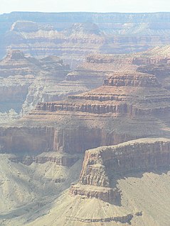
The Redwall Limestone is a resistant cliff-forming unit of Mississippian age that forms prominent, red-stained cliffs in the Grand Canyon, ranging in height from 500 feet (150 m) to 800 feet (240 m).

The Greenhorn Limestone or Greenhorn Formation is a geologic formation in the Great Plains Region of the United States, dating to the Cenomanian and Turonian ages of the Late Cretaceous period. The formation gives its name to the Greenhorn cycle of the Western Interior Seaway.

The Fort Hays Limestone is a member of the Niobrara Formation of the Colorado Group exposed in Colorado, Kansas, Nebraska, and South Dakota and is named for the bluffs near the old Fort Hays, a well-known landmark in western Kansas.
The Menard Limestone is a geologic formation in the Illinois Basin of southern Illinois, southwestern Indiana, and western Kentucky.
References
- ↑ Moores, E.M.; Fairbridge, Rhodes W. (1997). Encyclopedia of European & Asian Regional Geology. Springer. p. 259-260.
| | This South Ossetia-related article is a stub. You can help Wikipedia by expanding it. |