Related Research Articles
This is a list of articles related to plate tectonics and tectonic plates.


The main points that are discussed in the geology of Iran include the study of the geological and structural units or zones; stratigraphy; magmatism and igneous rocks; ophiolite series and ultramafic rocks; and orogenic events in Iran.

The base of rocks that underlie Borneo, an island in Southeast Asia, was formed by the arc-continent collisions, continent–continent collisions and subduction–accretion due to convergence between the Asian, India–Australia, and Philippine Sea-Pacific plates over the last 400 million years. The active geological processes of Borneo are mild as all of the volcanoes are extinct. The geological forces shaping SE Asia today are from three plate boundaries: the collisional zone in Sulawesi southeast of Borneo, the Java-Sumatra subduction boundary and the India-Eurasia continental collision.
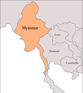
The geology of Myanmar is shaped by dramatic, ongoing tectonic processes controlled by shifting tectonic components as the Indian plate slides northwards and towards Southeast Asia. Myanmar spans across parts of three tectonic plates separated by north-trending faults. To the west, a highly oblique subduction zone separates the offshore Indian plate from the Burma microplate, which underlies most of the country. In the center-east of Myanmar, a right lateral strike slip fault extends from south to north across more than 1,000 km (620 mi). These tectonic zones are responsible for large earthquakes in the region. The India-Eurasia plate collision which initiated in the Eocene provides the last geological pieces of Myanmar, and thus Myanmar preserves a more extensive Cenozoic geological record as compared to records of the Mesozoic and Paleozoic eras. Myanmar is physiographically divided into three regions: the Indo-Burman Range, Myanmar Central Belt and the Shan Plateau; these all display an arcuate shape bulging westwards. The varying regional tectonic settings of Myanmar not only give rise to disparate regional features, but they also foster the formation of petroleum basins and a diverse mix of mineral resources.

The geology of Sweden is the regional study of rocks, minerals, tectonics, natural resources and groundwater in the country. The oldest rocks in Sweden date to more than 2.5 billion years ago in the Precambrian. Complex orogeny mountain building events and other tectonic occurrences built up extensive metamorphic crystalline basement rock that often contains valuable metal deposits throughout much of the country. Metamorphism continued into the Paleozoic after the Snowball Earth glaciation as the continent Baltica collided with an island arc and then the continent Laurentia. Sedimentary rocks are most common in southern Sweden with thick sequences from the last 250 million years underlying Malmö and older marine sedimentary rocks forming the surface of Gotland.
The geology of Ukraine is the regional study of rocks, minerals, tectonics, natural resources and groundwater in Ukraine. The oldest rocks in the region are part of the Ukrainian Shield and formed more than 2.5 billion years ago in the Archean eon of the Precambrian. Extensive tectonic evolution and numerous orogeny mountain-building events fractured the crust into numerous block, horsts, grabens and depressions. Ukraine was intermittently flooded as the crust downwarped during much of the Paleozoic, Mesozoic and early Cenozoic, before the formation of the Alps and Carpathian Mountains defined much of its current topography and tectonics. Ukraine was impacted by the Pleistocene glaciations within the last several hundred thousand years. The country has numerous metal deposits as well as minerals, building stone and high-quality industrial sands.
The geology of Belgium encompasses rocks, minerals and tectonic events stretching back more than 500 million years. Belgium covers an area of about 30,507 square kilometers and was instrumental in the development of geology. The extensive outcrops in Belgium became the standard reference points in stratigraphy as early as the mid-19th century. Some of them are internationally recognized features related to the Carboniferous and the Devonian periods. These rocks were folded by two orogeny mountain building events --the Hercynian orogeny, and Caledonian Orogeny. Paleozoic basement rocks cover much of the country and are overlain by Mesozoic and Cenozoic sediments.

The geology of Kazakhstan includes extensive basement rocks from the Precambrian and widespread Paleozoic rocks, as well as sediments formed in rift basins during the Mesozoic.

The geology of Kyrgyzstan began to form during the Proterozoic. The country has experienced long-running uplift events, forming the Tian Shan mountains and large, sediment filled basins.

The geology of Uzbekistan consists of two microcontinents and the remnants of oceanic crust, which fused together into a tectonically complex but resource rich land mass during the Paleozoic, before becoming draped in thick, primarily marine sedimentary units.
The geology of Turkmenistan includes two different geological provinces: the Karakum, or South Turan Platform, and the Alpine Orogen.
The geology of Romania is structurally complex, with evidence of past crustal movements and the incorporation of different blocks or platforms to the edge of Europe, driving recent mountain building of the Carpathian Mountains. Romania is a country located at the crossroads of Central, Eastern, and Southeastern Europe. It borders the Black Sea to the southeast, Bulgaria to the south, Ukraine to the north, Hungary to the west, Serbia to the southwest, and Moldova to the east.
The geology of Greece is highly structurally complex due to its position at the junction between the European and African tectonic plates.
The geology of the Czech Republic is very tectonically complex, split between the Western Carpathian Mountains and the Bohemian Massif.

The geology of Italy includes mountain ranges such as the Alps and the Apennines formed from the uplift of igneous and primarily marine sedimentary rocks all formed since the Paleozoic. Some active volcanoes are located in Insular Italy.
The geology of Newfoundland and Labrador includes basement rocks formed as part of the Grenville Province in the west and Labrador and the Avalonian microcontinent in the east. Extensive tectonic changes, metamorphism and volcanic activity have formed the region throughout Earth history.

The Junggar Basin, also known as the Dzungarian Basin or Zungarian Basin, is one of the largest sedimentary basins in Northwest China. It is located in Dzungaria in northern Xinjiang, and enclosed by the Tarbagatai Mountains of Kazakhstan in the northwest, the Altai Mountains of Mongolia in the northeast, and the Heavenly Mountains in the south. The geology of Junggar Basin mainly consists of sedimentary rocks underlain by igneous and metamorphic basement rocks. The basement of the basin was largely formed during the development of the Pangea supercontinent during complex tectonic events from Precambrian to late Paleozoic time. The basin developed as a series of foreland basins – in other words, basins developing immediately in front of growing mountain ranges – from Permian time to the Quaternary period. The basin's preserved sedimentary records show that the climate during the Mesozoic era was marked by a transition from humid to arid conditions as monsoonal climatic effects waned. The Junggar basin is rich in geological resources due to effects of volcanism and sedimentary deposition. According to Guinness World Records it is a land location remotest from open sea with great-circle distance of 2,648 km from the nearest open sea at 46°16′8″N86°40′2″E.

The 2021 Khövsgöl earthquake was a magnitude 6.7 earthquake that occurred on January 11, 2021. It was located about 50 km south of the Russian border in the Khövsgöl Lake.

The Central Asian Orogenic Belt (CAOB), also called the Altaids, is one of the world's largest Phanerozoic accretionary orogens, and thus a leading laboratory of geologically recent crustal growth. The orogenic belt is bounded by the East European Craton and the North China Craton in the Northwest-Southeast direction, as well as Siberia Craton and Tarim Craton in the Northeast-Southwest direction. It formed by ocean closures during Neoproterozoic to the late Phanerozoic time, from around 750 to 150 Ma. Like many other accretionary orogenic belts, the Central Asian Orogenic Belt consists of a huge amount of magmatic arcs, arc-related basins, accretionary complexes, seamounts, continental fragments and ophiolites. It is also considered a relatively distinctive collisional orogenic belt because widespread subduction-accretion complexes and arc magmatic rocks can be found in the region, but collision-related foreland basins are not common.
References
- ↑ Moores, E.M.; Fairbridge, Rhodes W. (1997). Encyclopedia of European & Asian Regional Geology. Springer. pp. 540–546.
- ↑ Moores & Fairbridge 1997, p. 545.
- ↑ Moores & Fairbridge 1997, pp. 541–542.
- ↑ Moores & Fairbridge 1997, pp. 543–544.