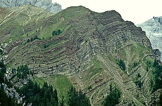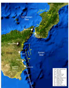
In geology, a rift is a linear zone where the lithosphere is being pulled apart and is an example of extensional tectonics. Typical rift features are a central linear downfaulted depression, called a graben, or more commonly a half-graben with normal faulting and rift-flank uplifts mainly on one side. Where rifts remain above sea level they form a rift valley, which may be filled by water forming a rift lake. The axis of the rift area may contain volcanic rocks, and active volcanism is a part of many, but not all, active rift systems.

An accretionary wedge or accretionary prism forms from sediments accreted onto the non-subducting tectonic plate at a convergent plate boundary. Most of the material in the accretionary wedge consists of marine sediments scraped off from the downgoing slab of oceanic crust, but in some cases the wedge includes the erosional products of volcanic island arcs formed on the overriding plate.

The 1693 Sicily earthquake struck parts of southern Italy near Sicily, Calabria, and Malta on 11 January at around 21:00 local time. This earthquake was preceded by a damaging foreshock on 9 January. The main quake had an estimated magnitude of 7.4 on the moment magnitude scale, the most powerful in Italian recorded history, and a maximum intensity of XI (Extreme) on the Mercalli intensity scale, destroying at least 70 towns and cities, seriously affecting an area of 5,600 square kilometres (2,200 sq mi) and causing the death of about 60,000 people.
The Philippine Fault System is a major inter-related system of geological faults throughout the whole of the Philippine Archipelago, primarily caused by tectonic forces compressing the Philippines into what geophysicists call the Philippine Mobile Belt. Some notable Philippine faults include the Guinayangan, Masbate and Leyte faults.
The 1783 Calabrian earthquakes were a sequence of five strong earthquakes that hit the region of Calabria in southern Italy, the first two of which produced significant tsunamis. The epicenters form a clear alignment extending nearly 100 km from the Straits of Messina to about 18 km SSW of Catanzaro. The epicenter of the first earthquake occurred in the plain of Palmi. The earthquakes occurred over a period of nearly two months, all with estimated magnitudes of 5.9 or greater. Estimates of the total number of deaths lie in the range 32,000 to 50,000.
The 1169 Sicily earthquake occurred on 4 February 1169 at 08:00 local time on the eve of the feast of St. Agatha of Sicily. It had an estimated magnitude of between 6.4 and 7.3 and an estimated maximum perceived intensity of X (Extreme) on the Mercalli intensity scale. The cities of Catania, Lentini and Modica were severely damaged, and the earthquake also triggered a paleotsunami. Overall, the earthquake is estimated to have caused the deaths of at least 15,000 people.
The Tyrrhenian Basin is a sedimentary basin located in the western Mediterranean Sea under the Tyrrhenian Sea. It covers a 231,000 km2 area that is bounded by Sardinia to the west, Corsica to the northwest, Sicily to the southeast, and peninsular Italy to the northeast. The Tyrrhenian basin displays an irregular seafloor marked by several seamounts and two distinct sub-basins - the Vavilov and Marsili basins. The Vavilov deep plain contains the deepest point of the Tyrrhenian basin at approximately 3785 meters. The basin trends roughly northwest–southeast with the spreading axis trending northeast–southwest.
The geology of Sicily records the collision of the Eurasian and the African plates during westward-dipping subduction of the African slab since late Oligocene. Major tectonic units are the Hyblean foreland, the Gela foredeep, the Apenninic-Maghrebian orogen, and the Calabrian Arc. The orogen represents a fold-thrust belt that folds Mesozoic carbonates, while a major volcanic unit is found in an eastern portion of the island. The collision of Africa and Eurasia is a retreating subduction system, such that the descending Africa is falling away from Eurasia, and Eurasia extends and fills the space as the African plate falls into the mantle, resulting in volcanic activity in Sicily and the formation of Tyrrhenian slab to the north.

The geology of Italy includes mountain ranges such as the Alps and the Apennines formed from the uplift of igneous and primarily marine sedimentary rocks all formed since the Paleozoic. Some active volcanoes are located in Insular Italy.
In early 1981 the eastern Gulf of Corinth, Greece was struck by three earthquakes with a magnitude greater than 6 over a period of 11 days. The earthquake sequence caused widespread damage in the Corinth–Athens area, destroying nearly 8,000 houses and causing 20–22 deaths.

The 1695 Linfen earthquake struck Shanxi Province in North China, Qing dynasty on May 18. Occurring at a shallow depth within the continental crust, the surface-wave magnitude 7.8 earthquake had a maximum intensity of XI on the China seismic intensity scale and Mercalli intensity scale. This devastating earthquake affected over 120 counties across eight provinces of modern-day China. An estimated 52,600 people died in the earthquake, although the death toll may have been 176,365.

The 1626 Lingqiu earthquake had an epicentre in Lingqiu County, Shanxi Province during the Ming dynasty. The estimated surface wave magnitude (Ms ) 7.0 earthquake caused many buildings to collapse. Over 5,200 people were killed.

The Shanxi Rift System or Fen–Wei Rift System is a zone of active extensional tectonics that forms the eastern margin of the Ordos Block in northern China. The zone extends for at least 900 km (560 mi) and runs south-southwest to north-northeast. The individual rift basins that make up the rift system have an overall en echelon geometry, consistent with a right lateral sense of strike-slip displacement across the zone. The basins contain a thick sedimentary sequence of Neogene age, which ranges from 2.0 to 3.8 km in thickness. The rift system is continuous with the Weihe Basin to the southwest, which became active during the Paleogene. Rupture of the major normal faults that bound the Weihe and Shanxi rift basins has caused many large and damaging historical earthquakes, including the 1303 Hongdong, 1556 Shaanxi, 1626 Lingqiu, 1695 Linfen and 1815 Pinglu events.
On December 5, 1456, the largest earthquake to occur on the Italian Peninsula struck the Kingdom of Naples. The earthquake had an estimated moment magnitude of Mw 7.19–7.4, and was centred near the town of Pontelandolfo in the present-day Province of Benevento, southern Italy. Earning a level of XI (Extreme) on the Modified Mercalli intensity scale, the earthquake caused widespread destruction in central and southern Italy. Estimates of the death toll range greatly with as many as 70,000 deaths reported. It was followed by two strong Mw 7.0 and 6.0 earthquakes to the north on December 30. The earthquake sequence is considered the largest in Italian history, and one of the most studied.
A series of mainshocks struck Calabria on March 27–28 and June 9, 1638. The first three earthquakes had moment magnitudes estimated to be 6.6–7.1. On June 9, another mainshock estimated at Mw 6.7 struck the same region, causing further damage and casualties. The four earthquakes resulted in as many as 30,000 fatalities.
The second shock in the 1962 Irpinia earthquake sequence was the largest and most destructive in a series of earthquakes in the southern Apennines. It occurred on 21 August at 18:19 CET, measuring 6.15 and assigned a maximum intensity of IX (Violent). It was preceded by an Mw 5.68 foreshock, and followed by a 5.34 aftershock. The earthquakes resulted in nearly 20 fatalities and significant property losses.
The 1706 Abruzzo earthquake, also known as the Maiella earthquake, occurred on November 3 at 13:00 CEST. The earthquake with a possible epicenter in the Central Apennine Mountains (Maiella), Abruzzo had an estimated moment magnitude of 6.6–6.84 Mw . It was assigned a maximum Mercalli intensity of XI (Extreme), causing tremendous destruction in Valle Peligna. At least 2,400 people were killed.

The Taupō Rift is the seismically active rift valley containing the Taupō Volcanic Zone, central North Island of New Zealand.
The Whakatāne Graben is a predominantly normal faulting tectonic feature of the northeastern aspect of the young, modern Taupō Rift in New Zealand. At the coast it is widening by about 7 mm (0.28 in)/year. This very geologically active graben was the site of the 1987 Edgecumbe earthquake, which caused up to 2 m of land subsidence. The discontinuity in the Taupō Volcanic Zone's faults imposed by the highly active Ōkataina Volcanic Centre, geography and geology mean the graben is usually regarded as including the actively expanding and lowering region onshore extending towards the coast. Some scientists have limited the Whakatāne Graben to only the offshore continuation of the Taupō Rift.
The 1659 Calabria earthquake devastated present-day southern Italy on 5 November. It had an estimated energy magnitude of 6.6. The towns of Filadelfia, Chiaravalle Centrale, Filogaso, Panaia, Polia Antica, San Demetrio Corone and Stefanaconi were assigned X (Extreme) on the Mercalli-Cancani-Sieberg scale. The reports of destruction corresponded with a 10 km (6.2 mi) section of the Serre Fault that did not rupture during the next major earthquakes in 1783. This meant the central portion of the Serre Fault is a probably candidate for the earthquake source. The rupture on this fault segment reduced the Coulomb stress, which was sufficient for it to remain unruptured in 1783. The 1659 earthquake affect the region between those affected by earthquakes on 7 February and 28 March 1783. It represents the first major earthquake in a seismic sequence on faults in southern Calabria, with the last major earthquake in 1908.


