The Savio is a river in the Emilia-Romagna region of northern Italy. Its source is in the province of Forlì-Cesena near Montecoronaro on Mount Castelvecchio which is near the western side of Mount Fumaiolo. The source is at an elevation of 1,126 metres (3,694 ft) and is marked by an iron monument. A wolf and the rings of the "caveja" are on this monument. The river flows near Verghereto and Bagno di Romagna as it winds through the mountains before entering Lago di Quarto. After leaving the lake, the river flows northeast near Sarsina and Mercato Saraceno before flowing north. The river winds for 96 kilometres (60 mi) along the valley. Its natural track has been preserved relatively well and, in the territory of Cesena, it shows an environment which is one of the purest of the whole Romagna. North of Cesena, the river crossed the border into the province of Ravenna. After a total course of 126 kilometres (78 mi) the river enters the Adriatic Sea north of Cervia by Lido di Classe and Lido di Savio.

The Aterno-Pescara is a river system in Abruzzo, eastern central Italy. The river is known as the Aterno near its source in the mountains, but takes the name Pescara, actually a tributary, nearer the city of Pescara and the Adriatic Sea.

The Agri is a river in the Basilicata region of southern Italy. In ancient times it was known as Aciris. The source of the river is in the Lucan Apennines north of Monte Volturino and west of Calvello in the province of Potenza. It is near the source of the Basento. The river flows south near Paterno before curving southeast. It flows near Tramutola, Viggiano, and Grumento Nova before entering a lake. After exiting the lake, the river flows eastward near Armento, Missanello, Aliano, and Sant'Arcangelo. A right tributary, the Racanello, enters the river in this area. The river forms the border between the province of Potenza and the province of Matera for part of this area of the river. It flows into a small lake before entering the province of Matera. The river flows for a short distance before entering Lago di Gannano. After exiting the lake, the river flows southeast near Tursi, Montalbano Jonico, and Scanzano Jonico before flowing into the Gulf of Taranto near Policoro.

The Montone is a river in the historical region of Romagna, which is in the present-day region of Emilia-Romagna in northern Italy. It is the northernmost river on the east-facing slopes of the Apennines to flow directly into the Adriatic Sea rather than entering the Po. Its Latin name was Utis or Vitis.

The Tronto is a 115-kilometre (71 mi) long Italian river that arises at Monti della Laga and ends in the Adriatic Sea at Porto d'Ascoli, San Benedetto del Tronto. It traverses the Lazio, Marche, and Abruzzo regions of Italy.

Lago di Scanno is a lake in the Province of L'Aquila, Abruzzo, Italy. It is located in the Appennino Abruzzese north of Parco Nazionale d'Abruzzo, Lazio e Molise. On its southern shore is Scanno and on its northern shore is Villalago. The Sagittario flows out of the lake towards the north. The part of the Sagittario river that flows into the lake from the south is known as the Tasso.

Cecita Lake is a man made lake in the province of Cosenza, Calabria, southern Italy.
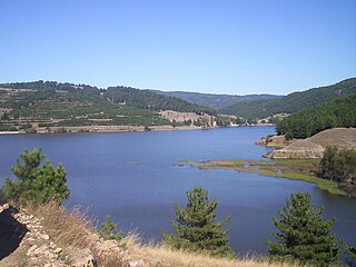
Lago di Bomba, also called Lago di Sangro, is a lake in the Province of Chieti, Abruzzo, Italy. At an elevation of 262 m, its surface area is 10 km². To the south of the lake is Villa Santa Maria and to the north of the lake is Bomba.

The Chienti is a river in the Marche region of Italy. Its source is near Serravalle di Chienti in the Appennino Umbro-Marchigiano mountains in the province of Macerata. The river flows northeast through the mountains past Muccia and enters and exits a small reservoir before entering Lago di Pievefavera. After exiting Lago di Pievefavera, the river continues flowing northeast before being joined by the Fiastrone at Belforte del Chienti. The river continues flowing northeast past Tolentino before being joined by the Fiastra south of Macerata. The river flows east near Corridonia and forms the border between the province of Macerata and the province of Fermo before flowing into the Adriatic Sea near Civitanova Marche.
The Bradano is a river in the Basilicata and Apulia regions of southern Italy. Its source is Lago Pesole in the province of Potenza. The river flows southeast near Monte Torretta, Acerenza, and Oppido Lucano. After crossing into the province of Matera, it is joined by a right tributary, the Alvo. The river flows near Irsina before being joined by a left tributary, the Basentello. Shortly after that, it is joined by another right tributary, the Bilioso. The river then enters Lago di San Giuliano. After flowing out of the lake, the Bradano is joined by a left tributary, the Gravina, and flows southeast near Montescaglioso before entering the province of Taranto. It is then joined by a left tributary, the Gravina di Matera, before re-entering the province of Matera after a short distance. The river flows near the border with the province of Taranto before entering the Gulf of Taranto near Lido di Metaponto.

The Sagittario is a river in Italy. It is located primarily in the province of L'Aquila in the Abruzzo region of southern Italy. The river is the main tributary of the Aterno-Pescara. Its source is located near Parco Nazionale d'Abruzzo, Lazio e Molise and Scanno. The river flows into Lago di Scanno near Scanno and flows out of the lake near Villalago. The portion of the river that enters the lake is known as the Tasso. The Sagittario flows north through the Appennino Abruzzese near Villalago, Bugnara, Sulmona and Pratola Peligna. It enters the Aterno-Pescara near Raiano and Popoli on the border with the province of Pescara.

The Fiastrone is a river in the province of Macerata in the Marche region of Italy. Its source is in the Sibillini Mountains near Bolognola. The river flows northwest through the mountains before entering Lago di Fiastra. The river then exits the lake and flows northeast through the mountains. It then exits the mountains and Monti Sibillini National Park and flows north until it reaches the Chienti and enters that river by Belforte del Chienti.

Monte Pennino is a mountain in the Appennino Umbro-Marchigiano range in Italy. The mountain is on the border between the province of Macerata in the Marche region of Italy and the province of Perugia in the Umbria region of Italy. The elevation of the mountain is 1,571 metres (5,154 ft).

Sorapiss, also referred to as Sorapis or Punta Sorapiss, is a mountain in the Dolomites within the Veneto region of northern Italy. Situated in the comune of Cortina d'Ampezzo, it has an elevation of 3,205 metres (10,515 ft). In its vicinity is a mountain pass of the same name, as well as Sorapiss Lake, at the foot of the mountain. The mountain range is part of the "Natural Park of the Ampezzo Dolomites".
The Savena is a river in the Tuscany and Emilia-Romagna regions of Italy. The source of the river is in the province of Florence west of Firenzuola in the Appennino Tosco-Emiliano mountains. The river flows north into the province of Bologna and flows near Monghidoro, Loiano, Pianoro and San Lazzaro di Savena before curving east and flowing into the Idice east of Bologna.

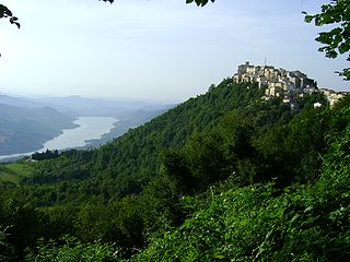
Lago di San Giuliano is a lake in the Basilicata region of southern Italy. The lake is located entirely within the province of Matera. It is southwest of Matera, east of Grottole, and north of Miglionico. The Bradano flows into the lake from the northwest and flows out of the lake to the southeast.

The Neto is a river in Calabria, southern Italy. It is the second largest river of Calabria after the Crati.
Lago di Ariamacina is a lake in the province of Cosenza, Calabria, southern Italy. It is located in the La Sila range within Sila National Park. The Neto flows into and out of the lake. The lake is a reservoir built between 1953 and 1955 by damming the Neto. Its purpose is to generate hydroelectricity. North of the lake is Lago di Cecita and south of the lake is Lago Arvo.
The Mucone is a river in the province of Cosenza, Calabria, southern Italy. The source of the river is in La Sila north of Botte Donato. It flows into Lago di Cecita and flows out of the lake near the western border of Sila National Park. The river flows northwest before curving west near Acri. It flows near Bisignano before flowing into the Crati east of Torano Castello. The Mucone is the largest right tributary of the Crati.
Lago Arvo is a lake in the province of Cosenza, Calabria, southern Italy. It is located in La Sila east of Aprigliano and west of San Giovanni in Fiore. The lake is south of Lago di Ariamacina and Botte Donato and northwest of Lago Ampollino. The Arvo flows into and out of the lake. The lake is a reservoir built between 1927 and 1931 by damming the Arvo. Its purpose is to generate hydroelectricity.