Preston is a coastal village and suburb of Weymouth in south Dorset, England. It is approximately 3 kilometres (2 mi) north-east of Weymouth town centre and 2 kilometres (1 mi) west of the village of Osmington.

Pazzano is a village and comune located in Locride's region in the province of Reggio Calabria.

Felitto is a town and comune in the province of Salerno in the Campania region of south-west Italy. It is famous for fusilli, a kind of handmade pasta, and the annual Fusillo festival.

Unthank Hall is a Grade II listed property now serving as commercial offices, situated on the southern bank of the River South Tyne east of Plenmeller, near Haltwhistle, Northumberland.

WXSM is a radio station serving the Tri-Cities, Tennessee vicinity with a sports format as a CBS Sports Radio affiliate. It broadcasts on AM frequency 640 kHz and is under ownership of Cumulus Media. WXSM also broadcasts Tennessee Titans NFL games, plus ETSU Buccaneer and Dobyns-Bennett High School games.

The Vallata dello Stilaro is a valley in the Province of Reggio Calabria of Southern Italy. It takes its name from river that flow in the area, the Stilaro.

The Ecomuseo delle ferriere e fonderie di Calabria is an ecomuseum in Bivongi, Calabria, southern Italy.
Podole is a village in the administrative district of Gmina Tłuchowo, within Lipno County, Kuyavian-Pomeranian Voivodeship, in north-central Poland. It lies approximately 6 kilometres (4 mi) north-west of Tłuchowo, 19 km (12 mi) east of Lipno, and 61 km (38 mi) south-east of Toruń.
Piszczatka is a village in the administrative district of Gmina Nurzec-Stacja, within Siemiatycze County, Podlaskie Voivodeship, in north-eastern Poland, close to the border with Belarus. It lies approximately 11 kilometres (7 mi) south-east of Nurzec-Stacja, 26 km (16 mi) east of Siemiatycze, and 78 km (48 mi) south of the regional capital Białystok.
Digov is a village in the Lerik Rayon of Azerbaijan. The village forms part of the municipality of Mistan.
Dervishalikyshlak is a village in the Khachmaz Rayon of Azerbaijan.
Skotniki Górne is a village in the administrative district of Gmina Wiślica, within Busko County, Świętokrzyskie Voivodeship, in south-central Poland. It lies approximately 9 kilometres (6 mi) north of Wiślica, 8 km (5 mi) south-west of Busko-Zdrój, and 52 km (32 mi) south of the regional capital Kielce.

The Serre Calabresi or Calabrian Serre are a mountain and hill area of Calabria, southern Italy, characterized by large extents of woods.

Monte Consolino is a mountain in the Serre Calabresi range, in the Vallata dello Stilaro of south-western Calabria, in southern Italy. Monte Consolino has an altitude of 701 metres (2,300 ft).

Monte Stella is a mountain in the Serre Calabresi, in the Locride, Calabria, southern Italy. It is part of the Vallata dello Stilaro, in the comune of Pazzano.

Suzhou North Railway Station is a station on Line 2 of Suzhou Rail Transit. The station is located in Xiangcheng District of Suzhou. It started service on December 28, 2013 with the opening of Line 2.

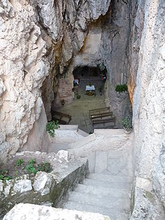
Hermit of Santa Maria della Stella or Sanctuary of Santa Maria della Stella is an Italian hermitage, sited in a natural cave at Pazzano (Calabria) on Monte Stella in Calabria, Italy.

Canillas is a ward (barrio) of Madrid belonging to the district of Hortaleza. it is also home to Parroquia de Santa Paula(Parish of Saint Paula.
Sprague is an unincorporated community in Bates County, in the U.S. state of Missouri.
Chaos Glacier is part of the Waddington Range in the southern British Columbia Coast Mountains in Canada, located at 51°25′25″N125°15′5″W. It flows to the north from Mount Tiedemann for approximately four kilometers before joining the larger Scimitar Glacier. The name was officially adopted in 1978 from field sketches of the area by mountaineer Don Munday. The area's steep terrain makes this an excellent example of a continuous ice fall.
This page is based on this
Wikipedia article Text is available under the
CC BY-SA 4.0 license; additional terms may apply.
Images, videos and audio are available under their respective licenses.


