Corno Bussola

Last updated
Corno Bussola
Mont de Boussolaz
Corno Bussola da est.png
East view of the Corno Bussola
Highest point
Elevation 3,023 m (9,918 ft) [1]
Prominence 355 m (1,165 ft)Key col: Palasinaz Pass (2668 m) [1]
Listing Alpine mountains above 3000 m
Coordinates 45°47′44″N7°44′11″E / 45.795426°N 7.736342°E / 45.795426; 7.736342 Coordinates: 45°47′44″N7°44′11″E / 45.795426°N 7.736342°E / 45.795426; 7.736342
Geography
Alps location map.png
Red triangle with thick white border.svg
Corno Bussola
Location in the Alps
Location Aosta Valley, Italy
Parent range Pennine Alps
Climbing
Easiest route Hike

Corno Bussola (French: Mont de Boussolaz [2] ) is a 3,023 metres high peak on the Italian side of the Pennine Alps.

Contents

Toponymy

Southern slopes. Corno Bussola 001.jpg
Southern slopes.

In Italian corno means horn, a term which often appears in toponymy with the meaning of peak, summit. Bussola means compass , but the original name of the mountain in the Valdôtain dialect has no relations with the compass, and its pronunciation is different too (not bùssola as in Italian but bussòla).

The French toponym shows a typical phonetical phenomenon in the French-speaking Alps, that is to say the mute final 'z'.

Geography

Corno Bussola is located in the Ayas valley and is the main elevation of the ridge dividing two small valleys tributaries of the Évançon: Mascognaz valley (north) and Conca di Palasinaz or Combe de Palasinaz. [3] The lowest point of the ridge, which connects Corno Bussola to the neighbouring Corno Vitello (or Chalberhòre in Walser German), is the Palasinaz Pass (2,688 m). Administratively the mountain belongs to the comunes of Ayas and Brusson.

Just below the Corno Bussola there is the natural environment of the Palasinaz Lakes.

SOIUSA classification

According to SOIUSA (International Standardized Mountain Subdivision of the Alps) the mountain can be classified in the following way: [4]

Access to the summit

Summit cross. Vetta Corno Bussola.jpg
Summit cross.

The summit can be accessed starting from the Arp Hut and following a waymarked foothpath which flanks some lakes (Palasinaz lake) and then reaches a pass at 2,805 m (Colletto Bussola or Petit col de Boussolaz), and then leads to the summit climbing its southern flanks. The route requires some hiking experience [5] From the top of the mountain, where stands a high metallic summit cross, one can enjoy a broad panoramic view encompassing some oth the highest mountains of Western Alps such as Breithorn, Castor, Pollux, Liskamm, Dufourspitze, Testa Grigia, Matterhorn, Corno Bianco and, in the distance, Monviso, Gran Paradiso, Mont Blanc and Grand Combin. [6]

Mountain huts

Maps

Related Research Articles

Biellese Alps Mountain range in Italy

The Biellese Alps are a sub-range of the Pennine Alps located between Piemonte and Aosta Valley (Italy).

Monte Bignone

Monte Bignone is a mountain in Liguria, northern Italy, part of the Ligurian Alps. It is located in the province of Imperia near Sanremo. It lies at an altitude of 1299 metres and lies within the San Romolo Natural Park.

Monte Bo

Monte Bo is a mountain in the Alpi Biellesi, a sub-range of Pennine Alps.

Colma di Mombarone

Colma di Mombarone is a mountain of the Biellese Alps, a sub-range of Pennine Alps, in northern Italy. It visually marks, along with Monte Gregorio on the opposite side, the entrance of Aosta Valley from the Po plain. On its top in 1900 was built a huge statue, still located there, of Jesus Christ.

Monte Tagliaferro

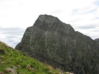
Monte Tagliaferro is a mountain of the Pennine Alps. It is one of the most popular hiking destination of Valsesia.

Corno Bianco

Corno Bianco is a mountain of the Pennine Alps. It's a popular climbing destination of Valsesia.

Monte Cresto

Monte Cresto (2,548 m) is the third highest peak of the Province of Biella after Monte Mars (2,600 m) and Monte Bo (2,556 m).

Testa Grigia (Aosta Valley)

Testa Grigia (3,315m) is a mountain on the Italian side of the Monte Rosa Massif in the Pennine Alps. It is the highest mountain of the ridge that separates the Lys valley (Gressoney-La-Trinité) from the Ayas Valley, in Aosta Valley.

Carmo di Brocchi Mountain in Italy

Carmo di Brocchi is a 1,610-metre (5,282 ft) mountain of the Ligurian Alps, in Italy.

Mont-Fallère Mountain in Italy

The Mont-Fallère or Mont Fallère is a 3,061.5 metres high mountain belonging to the Italian side of Pennine Alps.

Mont Tout Blanc Mountain in Italy

The Mont Tout Blanc is a 3,438.2 metres high mountain belonging to the Italian side of Graian Alps.

Punta Leynir Mountain in Italy

The Punta Leynir is a 3,238 metres high mountain belonging to the Italian side of Graian Alps.

Punta Bes Mountain in Italy

The Punta Bes is a 3,177 metres high mountain belonging to the Italian side of Graian Alps.

Cima Altemberg Mountain in Italy

The Altemberg is a mountain in the Pennine Alps of north-western Italy; with an elevation of 2,395 m (7,858 ft) is the highest peak of the Alpi Cusiane.

Monte Capio Mountain in Italy

The Monte Capio is a mountain in the Pennine Alps of north-western Italy; with an elevation of 2,172 m (7,126 ft) is one of the highest peaks of the Alpi Cusiane.

Monte I Gemelli Mountain in Italy

The Monte I Gemelli is an Alpine mountain located between Aosta Valley and Piedmont.

Cima Ciantiplagna Mountain in Italy

The Cima Ciantiplagna is a mountain in the Cottian Alps belonging to the Province of Turin (Italy).

Monte Massone Mountain in Italy

The Monte Massone, at an elevation of 2,161 m (7,090 ft), is a mountain of the Pennine Alps in North-western Italy.

Testa di Comagna Mountain in Italy

The Testa di Comagna is a 2,106 metres high peak on the Italian side of the Pennine Alps.

Palasinaz Lakes (Italy) Group of Italian Lakes

The Palasinaz Lakes are a group of lakes located in the Italian Alps, in the Aosta Valley region of northern Italy. They are of glacial origin and are situated in the southern foothills of the Monte Rosa group and are accessible from the villages of Brusson and Champoluc. The group is composed of the following lakes: the Lac Long, the Lago Pocia, the Lac du Couloir, the Lac Vert, and, the Lago della Battaglia.

References

  1. 1 2 "Navigatore Cartografico SCT (3.14.0)". geonavsct.partout.it (in Italian). Regione autonoma Valle d'Aosta.
  2. "Sentieri bassa valle - mappa" (PDF) (in Italian). Comune di Issogne. Retrieved 2018-11-26.
  3. "Navigatore Cartografico SCT (3.14.0)". geonavsct.partout.it. Regione Autonoma Valle d'Aosta. Retrieved 2018-11-26.
  4. Marazzi, Sergio (2005). Atlante Orografico delle Alpi. SOIUSA (in Italian). Priuli & Verlucca. p. 132. ISBN   978-88-8068-273-8.
  5. user mario-mont (2009-07-19). "Bussola (Corno) da Estoul, anello per il Colle Palasina e Punta del Lago" (in Italian). Retrieved 2018-11-26.
  6. "Corno Bussola mt. 3023" (in Italian). 2018-08-16. Retrieved 2018-11-26.