
South African Airways (SAA) is the flag carrier airline of South Africa. Founded in 1934, the airline is headquartered in Airways Park at O. R. Tambo International Airport in Johannesburg and operated a hub-and-spoke network, linking over 40 local and international destinations across Africa, Asia, Europe, North America, South America, and Oceania. The carrier joined Star Alliance in April 2006, making it the first African carrier to sign with one of the three major airline alliances.

The Ossola[ˈɔssola] is an area of Italy situated to the north of Lago Maggiore. It lies within the Province of Verbano-Cusio-Ossola. Its principal river is the Toce, and its most important town Domodossola.
The Society of American Archivists is the oldest and largest archivist association in North America, serving the educational and informational needs of more than 5,000 individual archivist and institutional members. Established in 1936, the organization serves upwards of 6,200 individual and member institutions.
Software as a service is a software licensing and delivery model in which software is licensed on a subscription basis and is centrally hosted. SaaS is also known as "on-demand software" and Web-based/Web-hosted software.
Rocca di Cambio is a comune and town in the province of L'Aquila in the Abruzzo region of Italy.
Antrona Schieranco is a comune (municipality) in the Province of Verbano-Cusio-Ossola in the Italian region Piedmont, located about 120 kilometres (75 mi) northeast of Turin and about 35 kilometres (22 mi) northwest of Verbania, in a branch of the Val d'Ossola, on the border with Switzerland.

Bognanco, population about 250, is a commune in the Province of Verbano-Cusio-Ossola in the Italian region Piedmont, located in an Alpine valley about 120 kilometres (75 mi) northeast of Turin immediately to the west of Domodossola and on the border with Switzerland. Its municipal boundaries extend over an area of 58.1 square kilometres (22.4 sq mi) that ranges in elevation from 380 to 2,713 metres above sea-level and borders on the Italian communes of Antrona Schieranco, Crevoladossola, Domodossola, Montescheno and Trasquera, and Zwischbergen in the Swiss canton Valais.

Calasca-Castiglione is a comune (municipality) in the Province of Verbano-Cusio-Ossola in the Italian region Piedmont, located about 120 kilometres (75 mi) northeast of Turin and about 35 kilometres (22 mi) northwest of Verbania.
Ceppo Morelli is a comune (municipality) in the Province of Verbano-Cusio-Ossola in the Italian region Piedmont, located about 100 kilometres (62 mi) northeast of Turin and about 35 kilometres (22 mi) west of Verbania, on the border with Switzerland.

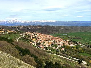
Montescheno is a comune (municipality) in the Province of Verbano-Cusio-Ossola in the Italian region Piedmont, located about 120 kilometres (75 mi) northeast of Turin and about 30 kilometres (19 mi) northwest of Verbania. As of 31 December 2004, it had a population of 452 and an area of 22.5 square kilometres (8.7 sq mi).
Vanzone con San Carlo is a comune (municipality) in the Province of Verbano-Cusio-Ossola in the Italian region Piedmont, located about 100 kilometres (62 mi) northeast of Turin and about 35 kilometres (22 mi) west of Verbania.

Viganella was a comune (municipality) in the Province of Verbano-Cusio-Ossola in the Italian region Piedmont, located about 120 kilometres (75 mi) northeast of Turin and about 30 kilometres (19 mi) northwest of Verbania. As of 31 December 2004, it had a population of 185 and an area of 13.7 square kilometres (5.3 sq mi).

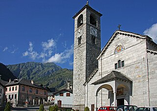
Villadossola is a town and comune of the Val d’Ossola in the Province of Verbano-Cusio-Ossola, Piedmont, northern Italy, some 120 kilometres (75 mi) northeast of Turin. It stands just south of Domodossola, to the west of the Toce, and at the mouth of the picturesque Valle Antrona, one of the seven side valleys of the Val d’Ossola.

The Stellihorn is a mountain of the Swiss Pennine Alps, overlooking the lake of Mattmark in the canton of Valais. It lies south of Saas-Almagell in the upper valley of Saas. The north side is covered by a glacier named Nollen Gletscher.
The Jazzihorn is a mountain of the Pennine Alps, located on the Swiss-Italian border. On the Italian side it is named Pizzo Cingino Nord as another summit is named Pizzo Cingino Sud on the south. The Jazzihorn has an elevation of 3,227 metres above sea level and lies between the valleys of Saastal (Valais) and Valle d'Antrona (Piedmont).

The Portjengrat is a mountain of the Pennine Alps, located on the border between Switzerland and Italy. It lies south of the Weissmies and the Zwischbergen Pass, where the international border diverges away from the main Alpine watershed. The summit of the Portjengrat has an elevation of 3,654 metres above sea level and is the tripoint between the valleys of Saas, Divedro and Antrona. It is the culminating point of the Antrona valley.

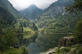
The Cingino Dam is a gravity masonry dam located 7 kilometres (4 mi) southwest of Antrona Schieranco, Province of Verbano-Cusio-Ossola in Piedmont, Italy. The dam creates Lago Cingino which is fed by the Antigine and Troncone streams. The reservoir has a surface area of 0.14 square kilometres (0.1 sq mi) and is maximum 2,262 metres (7,421 ft) above sea level, typically 2,250 metres (7,382 ft). It is one of five reservoirs within a hydroelectric complex in the Valle Antrona and helps supply the Campliccioli Power Plant with water for power production.

The Monte Moro Pass is an Alpine pass located on the border between Switzerland and Italy. It connects Saas-Almagell in the Swiss canton of Valais to Macugnaga, Province of Verbano-Cusio-Ossola, in the Italian region of Piedmont. The pass lies at the foot of Monte Moro.
The Alta Valle Antrona Natural Park is a nature reserve in Piedmont, in Italy.

Borgomezzavalle is a comune (municipality) in the Province of Verbano-Cusio-Ossola in the Italian region Piedmont. As of 2019 the population was 320.
