
The Pennine Alps, also known as the Valais Alps, are a mountain range in the western part of the Alps. They are located in Switzerland (Valais) and Italy.

The Haute Route is the name given to a route undertaken on foot or by ski touring between the Mont Blanc in Chamonix, France, and the Matterhorn, in Zermatt, Switzerland.

The Grand Combin is a mountain massif in the western Pennine Alps in the canton of Valais. At a height of 4,314 metres (14,154 ft) the summit of Combin de Grafeneire is one of the highest peaks in the Alps and the second most prominent of the Pennine Alps. The Grand Combin is also a large glaciated massif consisting of several summits, among which three are above 4000 metres. The highest part of the massif is wholly in Switzerland, although the border with Italy lies a few kilometres south.

Verbier is a village located in south-western Switzerland in the canton of Valais. It is a holiday resort and ski area in the Swiss Alps and is recognised as one of the premier off-piste resorts in the world. Some areas are covered with snow all year. Skiers have settled in the Verbier area in order to take advantage of the steep slopes, varied conditions, and resort culture.

The golden age of alpinism was the decade in mountaineering between Alfred Wills's ascent of the Wetterhorn in 1854 and Edward Whymper's ascent of the Matterhorn in 1865, during which many major peaks in the Alps saw their first ascents.
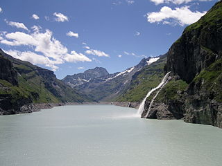
Lac de Mauvoisin is a reservoir in the canton of Valais, Switzerland. The reservoir is formed by the Mauvoisin Dam, which is 250 metres (820 ft) high. The dam is currently the 11th highest in the world, and the 6th highest arch dam. It was built in 1951–1957, and raised by 13.5 metres (44 ft) in 1991.

Mont Blanc de Cheilon is a mountain of the Pennine Alps, located in the Swiss canton of Valais. The mountain lies between the valleys of Bagnes and Arolla. Culminating at 3,870 metres above sea level, it is one of the highest summits between the Grand Combin to the west and the Dent Blanche to the east. The massif is glaciated, with the Cheilon Glacier to the north, the Giétro Glacier to the west, the Brenay Glacier to the south and the Tsijiore Nouve Glacier to the east.

Mont Vélan is a mountain of the Pennine Alps, located on the border between Switzerland and Italy. At 3,727, metres Mont Vélan is the highest summit lying between the Great St Bernard Pass and Grand Combin. Two large glaciers cover its northern flanks: Glacier de Tseudet (west) and Glacier de Valsoray (east). The Glacier de Proz, lying on the west side, was traversed during the first ascent.
The Petit Combin is a mountain of the Swiss Pennine Alps, located between the valleys of Entremont and Bagnes in the canton of Valais. It belongs to the Grand Combin massif.

La Ruinette is a mountain of the Swiss Pennine Alps, overlooking the Lake of Mauvoisin in the canton of Valais. With an altitude of 3,875 metres above sea level, it is the highest summit between the Grand Combin and the Dent Blanche. La Ruinette lies close to the better known Mont Blanc de Cheilon which has almost the same height.
The Combin de Corbassière is a mountain in the Pennine Alps, located south of Fionnay in the canton of Valais. It is part of the Grand Combin massif and lies on the west side of the Corbassière Glacier. It is also a main source for sparkling water.
The Combin de Boveire is a mountain of the Pennine Alps, located in the Grand Combin massif in Valais. It lies between the Boveire Glacier and the Corbassière Glacier.

The Valsorey Hut is a mountain hut of the Swiss Alpine Club, located south of Bourg-Saint-Pierre in the canton of Valais. The hut lies at a height of 3,030 metres above sea level, on the southwestern slopes of the Grand Combin in the Pennine Alps, facing Mont Vélan.

The Fenêtre de Durand is an Alpine pass connecting Switzerland and Italy. It connects Fionnay on its northern side to Valpelline on its southern side. At an elevation of 2,797 metres (9,177 ft) above sea level, the Fenêtre de Durand is the lowest pass on the main chain of the Alps between the Grand Combin and the Weissmies. The pass is traversed by a trail.

Valpelline is one of the side valleys of the Aosta Valley in north-west Italy. It shares its name with one of the communes within its territory (Valpelline).

Monte Emilius (3,559 m) is a mountain of the Graian Alps in Aosta Valley, north-western Italy. Located just above the town of Aosta, from where it is visible looking southwards behind the lower Becca di Nona, it is usually climbed starting from the ski resort of Pila, at a height of 1,870 m.

Corno Bussola is a 3,023 metres high peak on the Italian side of the Pennine Alps.

The Mont-Fallère or Mont Fallère is a 3,061.5 metres high mountain belonging to the Italian side of Pennine Alps.

Val de Bagnes, also called the Vallée de Bagnes is a valley located in the Entremont District in the Canton of Valais of Switzerland.

