
Mont Aiguille is a mountain in the Vercors Massif of the French Prealps, located 58 km (36 mi) south of Grenoble, in the commune of Chichilianne, and the département of Isère. The mountain, known as one of the Seven Wonders of Dauphiné, is a relatively flat limestone mesa surrounded by steep cliffs. The mountain lies within an area designated in 1970 as the Vercors Regional Natural Park. Mont Aiguille's limestone cliffs, especially on the northwest side, are popular with climbers. Its first climb in 1492 was said to mark the birth of mountaineering.

The Aiguille de Bionnassay is a mountain in the Mont Blanc massif of the Alps in France and Italy. It has been described as "one of the most attractive satellite peaks of Mont Blanc", and is located on its western side. The mountain's south and east ridges form the frontier between the two countries, and its summit is a knife-edge crest of snow and ice. Reaching it via any route provides a "splendid and serious snow and ice climb".
The Aiguille du Midi is a 3,842-metre-tall (12,605 ft) mountain in the Mont Blanc massif within the French Alps. It is a popular tourist destination and can be directly accessed by cable car from Chamonix that takes visitors close to Mont Blanc.

Les Contamines-Montjoie is a commune in the Haute-Savoie department in the Auvergne-Rhône-Alpes region in south-eastern France.

The Aiguille Verte, which is French for "Green Needle", is a mountain in the Mont Blanc massif in the French Alps.

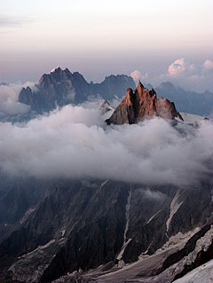
The Aiguille du Dru is a mountain in the Mont Blanc massif in the French Alps. It is situated to the east of the village of Les Praz in the Chamonix valley. "Aiguille" means "needle" in French.
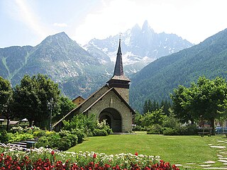
Les-Praz-de-Chamonix is a mountain village in the French Alps, part of the commune of Chamonix. Altitude: 1060 m (3477 ft.).

The Vanoise massif is a mountain range of the Graian Alps, located in the Western Alps. After the Mont Blanc Massif and the Massif des Écrins it is the third highest massif in France, reaching a height of 3,885 m at the summit of Grande Casse. It lies between Tarentaise Valley to the north and the Maurienne valley in the south. The range is the site of France's first National Park in 1963, the Vanoise National Park. The ski resorts of Tignes and Val-d'Isère and the 2,770-meter-high Col de l'Iseran are located in the eastern part of the range.

The Aiguille du Tour is a mountain in the Mont Blanc massif, located on the border between Switzerland and France. The voie normale on the mountain is graded F (facile) and can be climbed from either the Albert Premier Hut on the French side or the Trient Hut on the Swiss side.

The Aiguilles Dorées are a multi-summited mountain of the Mont Blanc massif, overlooking the Plateau du Trient in the canton of Valais. They lie east of the Petite Fourche, on the range between the glaciers of Trient and Saleina.
The Aiguille de l'A Neuve is a mountain of the Mont Blanc massif, located on the border between Switzerland and France. It lies close to the Tour Noir to the south.

The Aiguilles d’Arves is a mountain in the Arves massif in the French Alps. The mountain, comprising three separate peaks, is the highest point of the massif, and is located in the department of Savoie.

The Aiguille de la Vanoise is a mountain of Savoie, France. It lies in the Vanoise massif mountain range in the commune of Pralognan-la-Vanoise. It has an altitude of 2796 metres above sea level and is known for its great North Face which is 300 to 400m high.

The Argentière Hut is a refuge in the Mont Blanc massif in the Alps. Built in 1974 by the Club Alpin Français, it is located above the north bank of the Argentière Glacier in France at an altitude of 2,691 meters above sea level.

The Torino Hut is a high mountain refuge in the Alps in northwestern Italy. Located near the border with France, it is about 15 km (10 mi) southwest of Mont Dolent, the tripoint with Switzerland. The refuge is in the Mont Blanc massif above the town of Courmayeur in the Aosta Valley, Italy. It can be most easily accessed from the Italian side by the Skyway Monte Bianco cable car from La Palud in Courmayeur, with a change at the Pavilion du Mont Fréty. It can also be reached from Chamonix via the Aiguille du Midi, either by cable car which crosses the massif, or by a long crossing of the Glacier du Gèant. The refuge lies nearly directly above the 11.6 km (7.2 mi) Mont Blanc Tunnel, which passes deep underground, and connects Courmayer to Chamonix.
The Aiguille Noire de Peuterey is a mountain of the Mont Blanc massif in Italy, forming part of the Peuterey ridge to the summit of Mont Blanc with its higher neighbour, the Aiguille Blanche de Peuterey.

The Aiguille de Triolet is a mountain on the eastern part the Mont Blanc massif, on the border between France and Italy.
The Petite Aiguille Verte (3,512m) is a mountain in the Mont Blanc Massif of the French Alps.

The Aiguille de Tré-la-Tête is a mountain in the south of the Mont Blanc massif. Its highest point, the central southeast pinnacle, is 3,930 metres (12,894 ft) above sea level and is located in Italy. Only the northwest pinnacle is situated on the border with France. It forms a chain with the Dômes de Miage.

The Grande Aiguille Rousse is a mountain peak of the Graian Alps in Savoie, France, situated between the Maurienne and Tarentaise valleys near the Italian border. Reaching an altitude of 3,482 meters, it exceeds its junior to the west, the Petite Aiguille Rousse, by just 50 m (160 ft). Not far from Levanna, the Grande Aiguille Rousse overlooks Serrù Lake and the Gran Paradiso National Park in Italy.
