The Pennine Alps, also known as the Valais Alps, are a mountain range in the western part of the Alps. They are located in Italy and Switzerland (Valais).

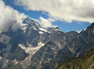
Monte Rosa is a mountain massif in the eastern part of the Pennine Alps, on the border between Italy and Switzerland (Valais). The highest peak of the massif, amongst several peaks of over 4.000 m, is the Dufourspitze, the second highest mountain in the Alps and western Europe, after Mont Blanc. The east face of the Monte Rosa towards Italy has a height of about 2.400 meters and is the highest mountain wall of the Alps.

The Dom is a mountain of the Pennine Alps, located between Randa and Saas-Fee in the canton of Valais in Switzerland. With a height of 4,545 m (14,911 ft), it is the seventh highest summit in the Alps, overall. Based on prominence, it can be regarded as the third highest mountain in the Alps, and the second highest in Switzerland, after Monte Rosa. The Dom is the main summit of the Mischabel group, which is the highest massif lying entirely in Switzerland.

The Alps form a large mountain range dominating Central Europe, including parts of Italy, France, Switzerland, Liechtenstein, Austria, Slovenia, Germany and Hungary.
The Jägerhorn is a mountain of the Pennine Alps, located on the border between Switzerland and Italy. It lies just north of Monte Rosa, at a height of 3,970 metres above sea level, and overlooks the village of Macugnaga on its east side, 2,600 metres below. On its west side it overlooks the Gorner Glacier.

Castor is a mountain in the Pennine Alps on the border between Valais, Switzerland and the Aosta Valley in Italy. It is the higher of a pair of twin peaks, the other being Pollux, named after the Gemini twins of Roman mythology. Castor's peak is at an elevation of 4,223 m (13,855 ft), and it lies between Breithorn and the Monte Rosa. It is separated from Pollux by a pass at 3,847 m (12,621 ft), named Passo di Verra in Italian and Zwillingsjoch in German.

Pollux is a mountain in the Pennine Alps on the border between Valais, Switzerland and the Aosta Valley in Italy. It is the lower of a pair of twin peaks, the other being Castor, named after the Gemini twins of Roman mythology. Pollux' peak is at an elevation of 4,092 m (13,425 ft). It is separated from Castor by a pass at 3,847 m (12,621 ft), named Passo di Verra in Italian, Col de Verra in French and Zwillingsjoch in German.

The Zumsteinspitze is a peak in the Pennine Alps on the border between Italy and Switzerland. It is a subpeak of Monte Rosa.

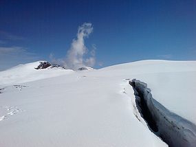
The Findel Glacier is a valley glacier in the Monte Rosa massif east of Zermatt in the Pennine Alps. It has a length of 8 km (5.0 mi) and covers an area of 19 km2 (7.3 sq mi).
The Concarena is a mountain in Lombardy, northern Italy. It is multi summited and its highest peak is the Cima della Bacchetta, with a height of 2,549 m.

SOIUSA is a proposal for a new classification system of the Alps from the geographic and toponomastic point of view. It was designed by Sergio Marazzi, Italian researcher and author of the Orographic Atlas of the Alps SOIUSA. His book was presented with the patronage of the Italian Alpine Club on 23 Jan 2006, but has yet to receive any formal acceptance.

Monte Bo is a mountain in the Alpi Biellesi, a sub-range of Pennine Alps.

Corno Bussola is a 3,023 metres high peak on the Italian side of the Pennine Alps.

The Cima Mongioia or simply Mongioia or Bric de Rubren is a 3,340 metres high mountain of the Cottian Alps.

The Altemberg is a mountain in the Pennine Alps of north-western Italy; with an elevation of 2,395 m (7,858 ft) is the highest peak of the Alpi Cusiane.

The Monte Capio is a mountain in the Pennine Alps of north-western Italy; with an elevation of 2,172 m (7,126 ft) is one of the highest peaks of the Alpi Cusiane.

The Monte Capezzone is a mountain in the Pennine Alps of north-western Italy; with an elevation of 2,421 m (7,943 ft) is the highest peak of the Strona Valley.

The Monte Massone, at an elevation of 2,161 m (7,090 ft), is a mountain of the Pennine Alps in North-western Italy.
The Testa di Comagna is a 2,106 metres high peak on the Italian side of the Pennine Alps.