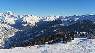
Savoie is a department in the Auvergne-Rhône-Alpes region of Southeastern France. Located in the French Alps, its prefecture is Chambéry. In 2017, Savoie had a population of 431,174.

Col du Tourmalet is one of the highest paved mountain passes in the French Pyrenees, in the department of Hautes-Pyrénées. Sainte-Marie-de-Campan is at the foot on the eastern side and the ski station La Mongie two-thirds of the way up. The village of Barèges lies on the western side, above the town of Luz-Saint-Sauveur.

Mont Cenis is a massif and a pass in Savoie (France), which forms the limit between the Cottian and Graian Alps.

Col des Mosses is a mountain pass in the western Bernese Alps of Switzerland. The pass is located in the municipality of Ormont-Dessous in the canton of Vaud. It links Aigle, to the south in the valley of the Rhone, with Château-d'Œx, to the north in the valley of the Sarine, and is flanked to the west by the Mont d'Or and to the east by the Pic Chaussy.

La Grave is a commune in the Hautes-Alpes department in southeastern France.

Col de l'Iseran is a mountain pass in France, the highest paved pass in the Alps. A part of the Graian Alps, it is in the department of Savoie, near the border with Italy, and is crossed by the D902 roadway.
The Aiguilles Rouges are a crystalline mountainous massif of the French Prealps, opposite the Mont Blanc Massif. The colour of the iron rich gneiss (metamorphique) mountains gives the range its name. The highest summit is the Aiguille du Belvédère at 2,965 metres (9,728 ft). At the southern end of the range, Le Brévent at 2,525 metres (8,284 ft) is accessible by a cable car in the Planpraz and the Brévent sections.

Col de la Croix-Morand is a high mountain pass of the Massif Central in France, in the department of Puy de Dôme, near Clermont-Ferrand. It inspired a song by Jean-Louis Murat.
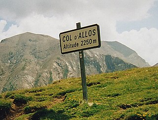
Col d'Allos is a high mountain pass in the Alps in the department of Alpes-de-Haute-Provence in France. It connects Barcelonnette in the Ubaye Valley and Colmars.

The Dent du Géant is a mountain in the Mont Blanc massif in France and Italy.

The Wildhorn is a mountain of the Alps, straddling the border between the Swiss cantons of Bern and Valais. At 3,248 metres (10,656 ft) above sea level, it is the highest summit of the Bernese Alps west of the Gemmi Pass. It forms a large glaciated massif, about 10 km wide, extending between the Sanetsch Pass and the Rawil Pass. Along with the Muverans, the Diablerets and the Wildstrubel, the Wildhorn is one of the four distinct mountain massifs of the Bernese Alps that lie west of the Gemmi Pass. The massif of the Wildhorn is at the centre between the valleys of the Saane, Simme and the Rhone (Valais). It comprises several distinct summits, including the Arpelistock, Le Sérac, the Geltenhorn, the Sex Noir, the Sex Rouge, the Schnidehorn and the Six des Eaux Froides. The main crest is between the glaciers named Tungelgletscher and Glacier du Wildhorn. South of the main summit is the almost equally high summit of Mont Pucel. The Wildhorn is surrounded by several large mountain lakes: the Lac de Sénin, the Lauenensee, the Iffigsee, the Lac de Tseuzier and the Lac des Audannes. The Tungelgletscher, on the north-east face, was measured as 1.9 km in length in 1973.

Saint-Sorlin-d'Arves is a commune in the Savoie department in the Auvergne-Rhône-Alpes region in south-eastern France.
The Rosablanche is a mountain of the Swiss Pennine Alps, overlooking the Lac des Dix in the canton of Valais. It lies on the range between the valleys of Bagnes (west) and Hérémence (east), north of Le Pleureur.

La Luette is a mountain of the Pennine Alps, located between the valleys of Bagnes and Hérens in the canton of Valais. It lies just south of Le Pleureur.
La Sâle is a mountain of the Swiss Pennine Alps, overlooking the Lac des Dix in the canton of Valais. It is located between the valleys of Bagnes and Hérens, north of Le Pleureur.

Col du Grand Colombier is a mountain pass in the Jura mountains in France.

The Aiguilles Rouges National Nature Reserve is a nature reserve located in the Aiguilles Rouges mountain range in the Haute-Savoie department in southeastern France.

The Chaîne de l'Épine, in the department of Savoie in southeast France, is a 20-kilometre (12 mi) long ridge of the Jura Mountains that runs north–south along the east side of the Lac d'Aiguebelette, from the Col de l'Épine west of Chambéry as far as the western edge of the Chartreuse Mountains, near the commune of Les Échelles. To the north, the ridge becomes the Mont du Chat ridge along the western shore of the Lac du Bourget. At the southern end, the ridge terminates at the Guiers River.

Lac de Vitalaca is a small lake in the Monte Renoso massif in the Corse-du-Sud department of France. It is at an altitude of 1,777 metres, and is surrounded by high mountains.

