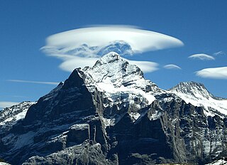
The Wetterhorn is a peak in the Swiss Alps towering above the village of Grindelwald. Formerly known as Hasle Jungfrau, it is one of three summits on a mountain named the "Wetterhörner", the highest of which is the Mittelhorn and the lowest and most distant the Rosenhorn. The latter peaks are mostly hidden from view from Grindelwald.
First, 1st or Firth, 1th is the ordinal form of the number one (#1).

The Brienzer Rothorn is a mountain of the Emmental Alps, in Switzerland. With an elevation of 2,350 metres (7,710 ft) above sea level, the Brienzer Rothorn is the highest summit of the range. To its west lies the Tannhorn, whilst to its east are Arnihaaggen, Höch Gumme and the Brünig Pass. On its south side it overlooks Lake Brienz, whilst to the north it looks out over the Waldemme valley.

The Grauspitz is a mountain in the Rätikon range of the Alps, located on the border between Liechtenstein and Switzerland. With an elevation of 2,599 metres (8,527 ft) above sea level, the Grauspitz is the highest mountain in Liechtenstein. It is also the highest summit of the Rätikon range west of the Schesaplana massif.
The Flüela Pass is a high mountain pass of the Swiss Alps in Graubünden. Traditionally considered the boundary between the Albula and Silvretta Alps, the pass crosses the watershed / drainage divide between the basins of the Rivers Rhine and Danube. The pass is overlooked by the Flüela Schwarzhorn and the Flüela Wisshorn. The summit of the pass lies between the lakes Lai da la Scotta and Lai Nair.

The Grosse Scheidegg is a mountain pass in the Bernese Alps of Switzerland, The pass crosses the col between the Schwarzhorn and the Wetterhorn mountains at an elevation of 1,962 m (6,437 ft).

The Schynige Platte is a small mountain ridge and a viewpoint in the Bernese Highlands and belongs to the Schwarzhorn group. The mountain range consists of three peaks: Gumihorn, Tuba, and the closest summit next to the viewpoint, Geiss. The viewpoint lies at an altitude of about 2,000 metres (7,000 ft), at the western end of a prominent ridge of the Schwarzhorn group, which separates the valley of the Schwarze Lütschine from Lake Brienz.

The Schwarzhorn is a mountain of the Bernese Alps, located between Brienz and Grindelwald in the Bernese Oberland. With a height of 2,928 metres above sea level, it is the highest summit of the group north of the Grosse Scheidegg Pass. The Schwarzhorn is also the highest point in the municipality of Brienz.

The Wildgärst is a mountain of the Bernese Alps, overlooking Lake Brienz in the Bernese Oberland. It lies north of the Schwarzhorn, on the range between Lake Brienz and the Grosse Scheidegg.
The Schwarzhorn is a mountain of the Lepontine Alps, located on the Swiss-Italian border, between the Binntal (Valais) and the Valle Dèvero (Piedmont). It lies north of the Scherbadung.
Schwarzhorn may refer to mountains/peaks in:
The Schwarzhorn is a mountain of the Bernese Alps, located west of Leukerbad in the canton of Valais. It lies approximately halfway between the Wildstrubel and the Gemmi Pass.

The Parpaner Schwarzhorn is a mountain of the Plessur Alps, overlooking Parpan in the canton of Graubünden. It lies north of the Parpaner Weisshorn.
The Schwarzhorn is a mountain of the Swiss Lepontine Alps, located west of Vals in the canton of Graubünden. It lies on the range between the Lumnezia and the Valser Tal, south of the Faltschonhorn.

The Schwarzhorn is a mountain in South Tyrol, Italy. It belongs to the Fiemme Mountains and is 2,439 m high.
The Sentischhorn is a mountain of the Albula Alps, located east of Davos in the canton of Graubünden. It lies on the range west of the Flüela Pass, that culminates at the Flüela Schwarzhorn.
The Schwarzhorn is a 4,321-metre-high summit in the Italian Alps just next to the Swiss border.

Piz Radönt is a mountain of the Albula Alps, overlooking the Fuorcla da Grialetsch in the canton of Graubünden. It lies south of the Flüela Schwarzhorn, on the range between the Dischma valley and the Flüela Pass.

Tilisuna-Schwarzhorn is a 2,460 m (AA) in the Sulzfluh sub-range of the Rätikon mountain range in the Austrian state Vorarlberg. It has a long ridge from north to south and wide scarps east and west. Besides the main summit, there is a second summit called Kleines Schwarzhorn. Both summits are separated by the col Fürkele. The alpine club hut Tilisunahütte (2208 m) is located near the Tilisuna-Schwarzhorn.
