
The Great St Bernard Pass is the third highest road pass in Switzerland, at an elevation of 2,469 m (8,100 ft). It connects Martigny in the canton of Valais in Switzerland with Aosta in the region Aosta Valley in Italy. It is the lowest pass lying on the ridge between the two highest mountains of the Alps, Mont Blanc and Monte Rosa. It is located on the main watershed that separates the basin of the Rhône from that of the Po.

The Gletscherhorn is a mountain of the Bernese Alps, located on the border between the Swiss cantons of Bern and Valais. It forms the eastern edge of the Lauterbrunnen Wall, south of the Jungfrau.

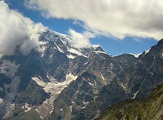
The Grand Combin is a mountain massif in the western Pennine Alps in the canton of Valais. At a height of 4,314 metres (14,154 ft) the summit of Combin de Grafeneire is one of the highest peaks in the Alps and the second most prominent of the Pennine Alps. The Grand Combin is also a large glaciated massif consisting of several summits, among which three are above 4000 metres. The highest part of the massif is wholly in Switzerland, although the border with Italy lies a few kilometres south.
The Jägerhorn is a mountain of the Pennine Alps, located on the border between Switzerland and Italy. It lies just north of Monte Rosa, at a height of 3,970 metres above sea level, and overlooks the village of Macugnaga on its east side, 2,600 metres below. On its west side it overlooks the Gorner Glacier.

Mont Ruan is a mountain in the Chablais Alps, overlooking the lake of Emosson in the Swiss canton of Valais. At 3,057 metres above sea level, its main summit is located 200 metres away from the French border, where lies a slightly lower summit.

La Ruinette is a mountain of the Swiss Pennine Alps, overlooking the Lake of Mauvoisin in the canton of Valais. With an altitude of 3,875 metres above sea level, it is the highest summit between the Grand Combin and the Dent Blanche. La Ruinette lies close to the better known Mont Blanc de Cheilon which has almost the same height.
The Grande Tête de By is a mountain of the Pennine Alps, located on the border between Italy and Switzerland. With a height of 3,587 metres above sea level, it is the highest summit on the Italian side of the Grand Combin massif.
The Jazzihorn is a mountain of the Pennine Alps, located on the Swiss-Italian border. On the Italian side it is named Pizzo Cingino Nord as another summit is named Pizzo Cingino Sud on the south. The Jazzihorn has an elevation of 3,227 metres above sea level and lies between the valleys of Saastal (Valais) and Valle d'Antrona (Piedmont).

The Portjengrat is a mountain of the Pennine Alps, located on the border between Switzerland and Italy. It lies south of the Weissmies and the Zwischbergen Pass, where the international border diverges away from the main Alpine watershed. The summit of the Portjengrat has an elevation of 3,654 metres above sea level and is the tripoint between the valleys of Saas, Divedro and Antrona. It is the culminating point of the Antrona valley.
The Wasenhorn is a mountain of the Lepontine Alps, located on the border between Switzerland and Italy. It lies halfway between Brig and Varzo, just north of Monte Leone, in the Simplon Pass area. Politically the Wasenhorn is split between the municipalities of Ried-Brig and Varzo.

The Wandfluhhorn is a mountain of the Lepontine Alps, located on the border between Switzerland and Italy. It overlooks Bosco/Gurin on its (Swiss) eastern side and Formazza on its (Italian) western side. Reaching a height of 2,863 metres above sea level, the Wandfluhhorn is the highest summit of the Bosco/Gurin valley.

Cima di Castello is a mountain of the Bregaglia Range, located on the border between Italy and Switzerland. With a height of 3,379 metres (11,086 ft) above sea level, it is the second highest mountain in the Bregaglia Range. Its summit lies between the valleys of the Albigna and Forno Glacier and the valley of Val Mello.

Piz Murtaröl is a mountain of the Ortler Alps, located on the border between Italy and Switzerland. With a height of 3,180 metres above sea level, it is the highest mountain in Val Mora. On its southern side it overlooks Passo di Fraéle.
The Tête de Ferret is a mountain of the Pennine Alps on the Swiss-Italian border. It lies just east of the Mont Blanc massif, between the Swiss Val Ferret (Valais) and the Italian Val Ferret.
The Aiguille des Angroniettes is a mountain of the Pennine Alps, located on the border between Switzerland and Italy. It lies on the main Alpine watershed, west of the Grand Golliat.

The Dents de Bouquetins or just the Bouquetins are a multi-summited mountain of the Alps between Switzerland and Italy. They form a ridge composed of several summits above 3,600 metres, of which the highest is 3,838 metres. The Bouquetins are the highest mountain on the main watershed of the Pennine Alps west of the Dent d'Hérens.

Theodul Pass, elevation 3,295 metres (10,810 ft), is a high mountain pass across the eastern Pennine Alps, connecting Zermatt in the Swiss canton of Valais and Breuil-Cervinia in the Italian region of Aosta Valley. Theodul Pass is the lowest and the easiest pass between the valleys of Zermatt and Valtournanche.
Mont Fourchon is a mountain of the Pennine Alps, located on the border between Switzerland and Italy. It is located on the main chain of the Alps, approximately halfway between the Grand Golliat and the Great St Bernard Pass.

