
Mont Blanc is the highest mountain in the Alps and Western Europe, and the highest mountain in Europe outside the Caucasus mountains, rising 4,805.59 m (15,766 ft) above sea level, located on the Franco-Italian border. It is the second-most prominent mountain in Europe, after Mount Elbrus, and the 11th most prominent mountain in the world.

The Great St Bernard Pass is the third highest road pass in Switzerland, at an elevation of 2,469 m (8,100 ft). It connects Martigny in the canton of Valais in Switzerland with Aosta in the region Aosta Valley in Italy. It is the lowest pass lying on the ridge between the two highest mountains of the Alps, Mont Blanc and Monte Rosa. It is located on the main watershed that separates the basin of the Rhône from that of the Po.

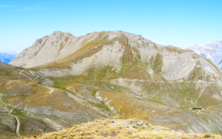
The Little St Bernard Pass is a mountain pass in the Alps on the France–Italy border. Its saddle is at 2188 metres above sea level. It is located between Savoie, France, and Aosta Valley, Italy, to the south of the Mont Blanc Massif, exactly on the main alpine watershed. There is also a Great St. Bernard Pass, famous for giving the St Bernard breed its name, and a San Bernardino Pass.

The Haute Route is the name given to a route undertaken on foot or by ski touring between the Mont Blanc in Chamonix, France, and the Matterhorn, in Zermatt, Switzerland.

The French Alps are the portions of the Alps mountain range that stand within France, located in the Auvergne-Rhône-Alpes and Provence-Alpes-Côte d'Azur regions. While some of the ranges of the French Alps are entirely in France, others, such as the Mont Blanc massif, are shared with Switzerland and Italy.

The Grand Combin is a mountain massif in the western Pennine Alps in the canton of Valais. At a height of 4,309 metres (14,137 ft) the summit of Combin de Grafeneire is one of the highest peaks in the Alps and the second most prominent of the Pennine Alps. The Grand Combin is also a large glaciated massif consisting of several summits, among which three are above 4000 metres. The highest part of the massif is wholly in Switzerland, although the border with Italy lies a few kilometres south.

Mont Cenis is a massif in Savoie (France), which forms the limit between the Cottian and Graian Alps.

The Ultra-Trail du Mont-Blanc (UTMB) is a mountain ultramarathon race, first held in 2003, that follows the route of the Tour du Mont Blanc. It has been regarded as the most competitive trail ultramarathon in the world.

The Alps form a large mountain range dominating Central Europe, including parts of Italy, France, Switzerland, Liechtenstein, Austria, Slovenia, Germany and Hungary.
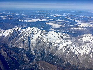
The Mont Blanc massif is a mountain range in the Alps, located mostly in France and Italy, but also straddling Switzerland at its northeastern end. It contains eleven major independent summits, each over 4,000 metres (13,123 ft) in height. It is named after Mont Blanc, the highest point in western Europe and the European Union. Because of its considerable overall altitude, a large proportion of the massif is covered by glaciers, which include the Mer de Glace and the Miage Glacier – the longest glaciers in France and Italy, respectively.

The Tour du Mont Blanc or TMB is one of the most popular long-distance walks in Europe. It circles the Mont Blanc massif, covering a distance of roughly 165 kilometres (103 mi) with 10 kilometres (6.2 mi) of ascent/descent and passing through parts of Switzerland, Italy and France.

Mont Dolent is a mountain in the Mont Blanc massif and lies on the border between Italy, Switzerland and France.
The Col Ferret is an Alpine pass between the canton of Valais and the Aosta Valley. It is crossed by the route of the Tour du Mont Blanc. Close to it stands the Petit Col Ferret, at an elevation of 2,490 metres (8,170 ft), which separates the Mont Blanc Massif from the Pennine Alps.

Val Ferret is the name shared by two valleys separated by the Col Ferret, a pass on the border between Italy and Switzerland. The valleys lie southeast of Mont Blanc Massif. The Swiss valley drains northeast towards Orsières and on into the Rhône basin; whereas the Italian valley drains southwest towards Courmayeur and on into the Po basin.

The Aiguille du Chardonnet is a mountain in the Mont Blanc massif in Haute-Savoie, France. It lies between the Glacier du Tour and the Argentière Glacier. The border with Switzerland runs just east of the summit. The East or Forbes Arete provides a popular and classic mountaineering route to the summit.
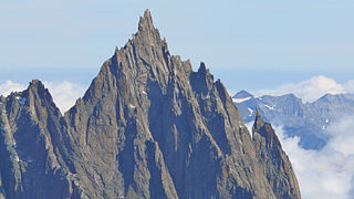
The Aiguille du Grépon, informally known as The Grepon, is a mountain in the Mont Blanc Massif in Haute-Savoie, France. The Grepon has a Southern and Northern peak, which are the highest points of a sharp granite ridge to the east of the Glacier des Nantillons above Chamonix and northeast of the Aiguille du Midi. A madonna statue is situated on the Southern peak.
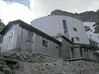
The Gonella Hut is a high elevation mountain hut in the Aosta Valley in the Mont Blanc massif area of the Alps. It lies at an elevation of 3071 metres, above Val Veny near Courmayeur in Italy. The refuge is located on the Italian 'normal route' to Mont Blanc.

The Aiguille de Tré-la-Tête is a mountain in the south of the Mont Blanc massif. Its highest point, the central southeast pinnacle, is 3,930 metres (12,894 ft) above sea level and is located in Italy. Only the northwest pinnacle is situated on the border with France. It forms a chain with the Dômes de Miage.
The Mont Froid is a 2,822 m high mountain of the northern Cottian Alps.


