
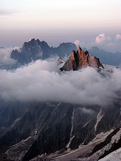
The Aiguille de Bionnassay is a mountain in the Mont Blanc massif of the Alps in France and Italy. It has been described as "one of the most attractive satellite peaks of Mont Blanc", and is located on its western side. The mountain's south and east ridges form the frontier between the two countries, and its summit is a knife-edge crest of snow and ice. Reaching it via any route provides a "splendid and serious snow and ice climb".
The Aiguille du Midi is a mountain in the Mont Blanc massif within the French Alps. It is a popular tourist destination and can be directly accessed by cable car from Chamonix that takes visitors close to Mont Blanc.

The Grand Combin is a mountain massif in the western Pennine Alps in Switzerland. With its 4,314 metres (14,154 ft) highest summit, the Combin de Grafeneire, it is one of the highest peaks in the Alps and the second most prominent of its range. The Grand Combin is also a large glaciated massif consisting of several summits, among which three are above 4000 metres.
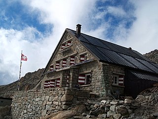
The Trient hut is a mountain hut in the Swiss alps, near the Swiss town of Martigny and the French town of Chamonix. The hut sits at an altitude of 3,170 m (10,400 ft), on a rock perched above the Trient Glacier. It can be reached on foot by mountaineers and strong hikers with experience of glacier travel. From the hut you can walk to the Albert Premier and Argentière huts in France, as well as the Cabane de Saleina (Switzerland) at the foot of the Aiguille d'Argentière. The hut is run by the SAC, the Swiss Alpine Club, and has 130 beds. It is a popular base for mountaineers exploring the area, e.g. Aiguille du Tour etc.
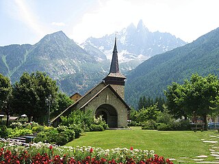
Les-Praz-de-Chamonix is a mountain village in the French Alps, part of the commune of Chamonix. Altitude: 1060m.

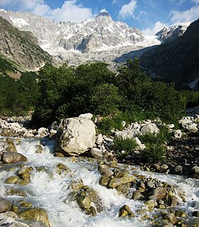
Mont Dolent is a mountain in the Mont Blanc massif and lies on the border between Italy, Switzerland and France.

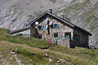
The Albert Premier Hut, sometimes known as Albert 1er is located on the Haute Route between Chamonix, France and Zermatt, Switzerland. It is at 2,702 metres (8,865 ft) above sea level. It is a popular hut with day hikers because of the short hike and beautiful views, like those into Chamonix Valley. The hut is usually used less by hikers attempting the entire Haute Route, but is popular as a base for climbers attempting the Aiguille du Chardonnet and the Aiguille du Tour.

The Tour Noir is a mountain in the Mont Blanc massif on the Swiss-French border. It is located between the Aiguille d'Argentière and Mont Dolent.

The Pointe des Grands is a mountain of the Mont Blanc Massif, located on the border between France and Switzerland, north-west of the Aiguille du Tour.

The Pointe des Berons is a mountain of the Mont Blanc Massif, located on the border between Switzerland and France. It lies approximately halfway between the Col de Balme and the Aiguille du Tour. The east (Swiss) side is covered by the Glacier des Berons.
The Aiguille de l'A Neuve is a mountain of the Mont Blanc massif, located on the border between Switzerland and France. It lies close to the Tour Noir to the south.

Pointe Kurz is a mountain of the Mont Blanc Massif, located on the border between France and Switzerland. It lies between the glaciers of Argentière and L'A Neuve, west of La Fouly, the closest locality.

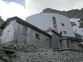
The Cosmiques Hut is a mountain hut in the Mont Blanc massif in the French Alps at an altitude of 3,613 m. It is a large structure capable of accommodating 148 mountaineers. It was constructed in 1990 on a rock promontory situated between the Col du Midi and the base of the Cosmiques Arête which descends southwards from the Aiguille du Midi. It gives access to a number of classic alpine mountaineering routes, and has proved to be extremely popular with mountaineers, so much so that in the summer months prior booking a few days beforehand is essential in order to secure a bed. The Hut is wardened between mid-February and mid-October. In winter the nearby Abri Simond Hut is left unlocked, although this has no cooking facilities, heating or water.
Refugio Elisabetta is a refuge in the Italian Alps at an altitude of 2,195 m, which provides a convenient overnight stage for walkers undertaking the Tour du Mont Blanc. It is located 3 km north-east of the Col de la Seigne, at the south-west end of the Mont Blanc massif, and provides good views of Mont Blanc and the Aiguille Noire de Peuterey. Because of its popularity, plus the fact that there are no other huts along this part of the Tour du Mont Blanc, walkers are advised to book in advance during the peak periods in July and August.

The Torino Hut is a high mountain refuge in the Alps in northwestern Italy. Located near the border with France, it is about 15 km (10 mi) southwest of Mont Dolent, the tripoint with Switzerland. The refuge is in the Mont Blanc massif above the town of Courmayeur in the Aosta Valley, Italy. It can be most easily accessed from the Italian side by the Skyway Monte Bianco cable car from La Palud in Courmayeur, with a change at the Pavilion du Mont Fréty. It can also be reached from Chamonix via the Aiguille du Midi, either by cable car which crosses the massif, or by a long crossing of the Glacier du Gèant. The refuge lies nearly directly above the 11.6 km (7.2 mi) Mont Blanc Tunnel, which passes deep underground, and connects Courmayer to Chamonix.

The Aiguille du Chardonnet is a mountain in the Mont Blanc massif in Haute-Savoie, France. It lies between the Glacier du Tour and the Glacier d'Argentière. The border with Switzerland runs just east of the summit.
The Gonella Hut is a high altitude mountain hut in the Aosta Valley in the Mont Blanc massif area of the Alps. It lies at an altitude of 3071 metres, above Val Veny near Courmayeur in Italy. The refuge is located on the Italian 'normal route' to Mont Blanc.

The Aiguilles Marbrées is a mountain peak in the Mont Blanc massif, above the Glacier du Géant, with its summits forming part of the frontier between France and Italy. It is situated between the Col du Rochefort and the Col du Géant, and is easily accessed from the Torino Hut at Pointe Helbronnner.

The Aiguilles d'Entrèves is a mountain peak in the Mont Blanc massif of the Alps. It is situated at the head of the Glacier du Géant, and its rocky summit ridge forms part of the frontier between France and Italy. It lies east of the Tour Ronde, between the Col d'Entrèves and the Col Occidental de Toule. It has a steep, sound face of red granite and can be readily accessed from the Torino Hut/Pointe Helbronner.


