Aiguille Noire de Peuterey

Last updated
Aiguille Noire de Peuterey
Aiguille Noire de Peuterey 002.JPG
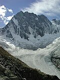
The Aiguille Noire de Peuterey, with les Dames Anglaises (right)
Highest point
Elevation 3,773 m (12,379 ft)
Prominence 274 m (899 ft)  OOjs UI icon edit-ltr-progressive.svg
Isolation 0.72 km (0.45 mi)  OOjs UI icon edit-ltr-progressive.svg
Listing Alpine mountains above 3000 m
Coordinates 45°48′54″N6°53′37″E / 45.81500°N 6.89361°E / 45.81500; 6.89361 Coordinates: 45°48′54″N6°53′37″E / 45.81500°N 6.89361°E / 45.81500; 6.89361
Geography
Location Aosta Valley, Italy
Parent range Mont Blanc massif, Graian Alps
Geology
Mountain type Granite
Climbing
First ascent 5 August 1877 by Lord Wentworth with J.B. Bich and Emile Rey
Easiest route East ridge (AD-) from the refuge Borelli
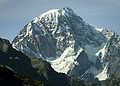
The Aiguille Noire de Peuterey (3,773 m) is a mountain of the Mont Blanc massif in Italy, forming part of the Peuterey ridge to the summit of Mont Blanc with its higher neighbour, the Aiguille Blanche de Peuterey.

Contents

The best-known route on the mountain is the south ridge (TD), first climbed by Karl Brendel and Hermann Schaller, on 26 and 27 August 1930; it remains one of the great classic rock routes in the massif.

The first ascent of the complete Peuterey ridge including the Aiguille Noire de Peuterey (the Intégrale) was on 28–31 July 1934 by Adolf Göttner, Ludwig Schmaderer and Ferdinand Krobath. On 21 August 2010 23-year-old Chloé Graftiaux, a leading Belgian sport climber, fell to her death on the mountain. [1]

Related Research Articles

<span class="mw-page-title-main">Mont Blanc</span> Highest mountain in the Alps (4,808 m)

Mont Blanc is the highest mountain in the Alps and Western Europe, rising 4,807.81 m (15,774 ft) above sea level. It is the second-most prominent mountain in Europe, after Mount Elbrus, and it is the eleventh most prominent mountain summit in the world.

Aiguille de Bionnassay Mountain in the Mont Blanc massif

The Aiguille de Bionnassay is a mountain in the Mont Blanc massif of the Alps in France and Italy. It has been described as "one of the most attractive satellite peaks of Mont Blanc", and is located on its western side. The mountain's south and east ridges form the frontier between the two countries, and its summit is a knife-edge crest of snow and ice. Reaching it via any route provides a "splendid and serious snow and ice climb".

Aiguille du Midi Mountain in the French Alps

The Aiguille du Midi is a 3,842-metre-tall (12,605 ft) mountain in the Mont Blanc massif within the French Alps. It is a popular tourist destination and can be directly accessed by cable car from Chamonix that takes visitors close to Mont Blanc.

Walter Bonatti Italian mountaineer

Walter Bonatti was an Italian mountain climber, explorer and journalist. He was noted for his many climbing achievements, including a solo climb of a new route on the south-west pillar of the Aiguille du Dru in August 1955, the first ascent of Gasherbrum IV in 1958, and, in 1965, the first solo climb in winter of the North face of the Matterhorn on the mountain's centenary year of its first ascent. Immediately after his extraordinary solo climb on the Matterhorn Bonatti announced his retirement from professional climbing at the age of 35 and after 17 years of climbing activity. He authored many mountaineering books and spent the remainder of his career travelling off the beaten track as a reporter for the Italian magazine Epoca. He died on 13 September 2011 of pancreatic cancer in Rome aged 81, and was survived by his life partner, the actress Rossana Podestà.

Grand Combin Mountain massif in the western Pennine Alps, in the Swiss canton of Valais

The Grand Combin is a mountain massif in the western Pennine Alps in the canton of Valais. At a height of 4,314 metres (14,154 ft) the summit of Combin de Grafeneire is one of the highest peaks in the Alps and the second most prominent of the Pennine Alps. The Grand Combin is also a large glaciated massif consisting of several summits, among which three are above 4000 metres. The highest part of the massif is wholly in Switzerland, although the border with Italy lies a few kilometres south.

<span class="mw-page-title-main">Mont Blanc massif</span> Mountain range in the Alps

The Mont Blanc massif is a mountain range in the Alps, located mostly in France and Italy, but also straddling Switzerland at its northeastern end. It contains eleven major independent summits, each over 4,000 metres (13,123 ft) in height. It is named after Mont Blanc, the highest point in western Europe and the European Union. Because of its considerable overall altitude, a large proportion of the massif is covered by glaciers, which include the Mer de Glace and the Miage Glacier – the longest glaciers in France and Italy, respectively.

Aiguille Blanche de Peuterey Mountain of the Mont Blanc massif in Italy

The Aiguille Blanche de Peuterey is a mountain of the Mont Blanc massif in Italy. It is considered the most difficult and serious of the alpine 4000-m mountains to climb.

<span class="mw-page-title-main">Aiguille d'Argentière</span> Mountain in the Mont Blanc massif

The Aiguille d'Argentière is a mountain in the Mont Blanc massif on the border between France and Switzerland.

Humphrey Owen Jones was a Welsh chemist and mountaineer.

Rifugio Elisabetta

Rifugio Elisabetta is a refuge in the Italian Alps at an altitude of 2,195 m, which provides a convenient overnight stage for walkers undertaking the Tour du Mont Blanc. It is located 3 km north-east of the Col de la Seigne, at the south-west end of the Mont Blanc massif, and provides good views of Mont Blanc and the Aiguille Noire de Peuterey. Because of its popularity, plus the fact that there are no other huts along this part of the Tour du Mont Blanc, walkers are advised to book in advance during the peak periods in July and August.

Aiguille du Chardonnet Mountain in the Mont Blanc massif in Haute-Savoie, France

The Aiguille du Chardonnet is a mountain in the Mont Blanc massif in Haute-Savoie, France. It lies between the Glacier du Tour and the Argentière Glacier. The border with Switzerland runs just east of the summit. The East or Forbes Arete provides a popular and classic mountaineering route to the summit.

<span class="mw-page-title-main">Chloé Graftiaux</span> Belgian sport climber

Chloé Graftiaux was a Belgian sport climber and alpinist who fell to her death on the 3,773-metre (12,379 ft) Aiguille Noire de Peuterey in the Mont Blanc massif, aged 23.

James Eccles English mountaineer and geologist

James Eccles FGS was an English mountaineer and geologist who is noted for making a number of first ascents in the Alps during the silver age of alpinism.

Aiguille de Tré la Tête Mountain in the south of the Mont Blanc massif

The Aiguille de Tré-la-Tête is a mountain in the south of the Mont Blanc massif. Its highest point, the central southeast pinnacle, is 3,930 metres (12,894 ft) above sea level and is located in Italy. Only the northwest pinnacle is situated on the border with France. It forms a chain with the Dômes de Miage.

Émile Rey Italian mountain guide and mountaineer (1846-1895)

Émile Rey was an alpine mountain guide from Aosta Valley in Italy. Dubbed "the Prince of Guides" in Courmayeur, he was one of the most renowned guides at the end of the 19th century, making many first ascents on some of the highest and most difficult mountains in the Mont Blanc massif of the Alps. He has been described as "one of the greatest guides of his generation."

Tour Ronde Mountain in the Mont Blanc massif

The Tour Ronde is a mountain in the Mont Blanc massif of the Alps, situated on the border between France and Italy. It is a prominent mountain, some 3.5 km north-east of Mont Blanc, but is effectively part of a continuation of the south eastern spur of Mont Maudit which forms a frontier ridge between the two countries. It is easily accessible to mountaineers and provides not only a very good viewpoint from its summit of the Brenva face and the major peaks on the southern side of Mont Blanc, but it also offers a popular introduction to alpine climbing of all grades, including a north face ascent.

Aiguilles Marbrées Mountain peak in the Mont Blanc massif

The Aiguilles Marbrées, is a mountain peak in the Mont Blanc massif, above the Glacier du Géant, with its summits forming part of the frontier between France and Italy. It is situated between the Col de Rochefort and the Col du Géant, and is easily accessed from the Torino Hut at Pointe Helbronner.

Aiguilles dEntrèves Mountain peak in the Mont Blanc massif of the Alps

The Aiguilles d'Entrèves is a mountain peak in the Mont Blanc massif of the Alps. It is situated at the head of the Glacier du Géant, and its rocky summit ridge forms part of the frontier between France and Italy. It lies east of the Tour Ronde, between the Col d'Entrèves and the Col Occidental de Toule. It has a steep, sound face of red granite and can be readily accessed from the Torino Hut/Pointe Helbronner.

Aiguille de Toule Mountain peak in the Mont Blanc massif

The Aiguille de Toule is a mountain peak in the Mont Blanc massif of the Alps. Its summit is one of a number which form part of the mountainous frontier ridge between France and Italy which descends eastwards from Mont Blanc and continues towards the Grandes Jorasses and Mont Dolent.

Aiguille de la Brenva Mountain peak in the Mont Blanc massif

The Aiguille de la Brenva is a remote rocky mountain peak in the Mont Blanc massif of the Alps. It lies wholly within Italy on a ridge descending south-east from the Tour Ronde. It has been described as "a spectacular fin with a fine E face". It stands on a ridge separating the Entrèves glacier from the Brenva glacier, yet is somewhat overshadowed by its larger neighbours, such as the Aiguille Blanche and the Aiguille Noire de Peuterey. Nevertheless, it is a distinctive peak, offering a number of very challenging climbs, especially on its east face which consists of vertical granite flakes and cracks. On its northern side stands a distinctive, slender rock pinnacle about 60 metres high, known as the Père Eternel.

References

  1. "Goodbye Chloé Graftiaux". PlanetMountain.com. 2010-08-23. Archived from the original on 28 August 2010. Retrieved 2010-08-23.