
Mont Blanc is the highest mountain in the Alps and Western Europe, rising 4,807.81 m (15,774 ft) above sea level. It is the second-most prominent mountain in Europe, after Mount Elbrus, and it is the eleventh most prominent mountain summit in the world. The mountain stands between the regions of Aosta Valley, Italy, and Savoie and Haute-Savoie, France. It gives its name to the Mont Blanc massif, bordering Switzerland and forming part of a larger range referred to as the Graian Alps. The location of the summit of Mont Blanc is on the watershed line between the valleys of Ferret and Veny in Italy and the valleys of Montjoie, and Arve in France, on the border between the two countries. Ownership of the summit area has long been a subject of historical dispute between the two countries.

The Ultra-Trail du Mont-Blanc (UTMB) is a single-stage mountain ultramarathon, first held in 2003, that follows the route of the Tour du Mont Blanc.

The Mont Blanc massif is a mountain range in the Alps, located mostly in France and Italy, but also straddling Switzerland at its northeastern end. It contains eleven major independent summits, each over 4,000 metres (13,123 ft) in height. It is named after Mont Blanc, the highest point in western Europe and the European Union. Because of its considerable overall altitude, a large proportion of the massif is covered by glaciers, which include the Mer de Glace and the Miage Glacier – the longest glaciers in France and Italy, respectively.

The Tour du Mont Blanc or TMB is one of the most popular long-distance walks in Europe. It circles the Mont Blanc massif, covering a distance of roughly 170 kilometres (110 mi) with 10 kilometres (6.2 mi) of ascent/descent and passes through parts of Switzerland, Italy and France.

Mont Blanc de Courmayeur is a point on the south-east ridge of Mont Blanc that forms the peak of the massive south-east face of the mountain. It is connected to the main summit via the Col Major.
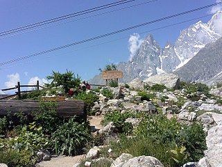
The alpine botanical garden Saussurea is the highest alpine botanical garden in Europe, at 2,173 metres above sea level. It is located in Courmayeur, Aosta Valley, Italy. The Saussurea garden is one of the four alpine botanical gardens in the Aosta Valley, and its 7,000 square metres contain the typical alpine flora of Mont Blanc. Its name comes from Horace-Bénédict de Saussure, who made the first known ascent of Mont Blanc in 1786, and from whom the flower Saussurea alpina also takes its name. It is open from June to September.

Val Ferret is the name shared by two valleys separated by the Col Ferret, a pass on the border between Italy and Switzerland. The valleys lie southeast of Mont Blanc Massif. The Swiss valley drains northeast towards Orsières and on into the Rhône basin; whereas the Italian valley drains southwest towards Courmayeur and on into the Po basin.
The Valdigne is the upper part of the Aosta Valley in north-west Italy. It is traversed by the Dora Baltea, a tributary of the Po.

The Cosmiques Hut is a mountain hut in the Mont Blanc massif in the French Alps at an altitude of 3,613 m. It is a large structure capable of accommodating 148 mountaineers. It was constructed in 1990 on a rock promontory situated between the Col du Midi and the base of the Cosmiques Arête which descends southwards from the Aiguille du Midi. It gives access to a number of classic alpine mountaineering routes, and has proved to be extremely popular with mountaineers, so much so that in the summer months prior booking a few days beforehand is essential in order to secure a bed. The Hut is wardened between mid-February and mid-October. In winter the nearby Abri Simond Hut is left unlocked, although this has no cooking facilities, heating or water.

Refuge Elena, sometimes also refuge Hélène, is a refuge in the Alps in Aosta Valley, Italy.
The Quintino Sella Hut is a very remote bivouac hut in the Mont Blanc massif of the Alps in Aosta Valley, Italy. Built in the 1920s, it is perched on rocks on the south-western flank of the Rocher du Mont Blanc at an altitude of 3,396 m. It is owned by the CAI and can accommodate up to sixteen people with bunk and blankets provided, but no stove or warden.

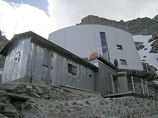
The Torino Hut is a high mountain refuge in the Alps in northwestern Italy. Located near the border with France, it is about 15 km (10 mi) southwest of Mont Dolent, the tripoint with Switzerland. The refuge is in the Mont Blanc massif above the town of Courmayeur in the Aosta Valley, Italy. It can be most easily accessed from the Italian side by the Skyway Monte Bianco cable car from La Palud in Courmayeur, with a change at the Pavilion du Mont Fréty. It can also be reached from Chamonix via the Aiguille du Midi, either by cable car which crosses the massif, or by a long crossing of the Glacier du Gèant. The refuge lies nearly directly above the 11.6 km (7.2 mi) Mont Blanc Tunnel, which passes deep underground, and connects Courmayer to Chamonix.

Val Veny is a lateral valley of the Mont Blanc massif, lying to the south-west of Courmayeur. The valley head is at the Seigne Pass.

Notre-Dame de Guérison is a Christian sanctuary situated in Courmayeur, at the foot of Mont Chétif, along the Val Veny road that leads to the Seigne pass, also known as the "Cremonis Iugum", used by the Romans to reach Gaul. It is well-known both in Italy and abroad, not only because of the surrounding landscape, but because it is very easy to reach by car from May to November and above all, is situated very close to an internationally famous tourist resort.
The Gonella Hut is a high altitude mountain hut in the Aosta Valley in the Mont Blanc massif area of the Alps. It lies at an altitude of 3071 metres, above Val Veny near Courmayeur in Italy. The refuge is located on the Italian 'normal route' to Mont Blanc.

Skyway Monte Bianco is a cable car in the Alps, linking the Italian town of Courmayeur with Pointe Helbronner on the southern side of the Mont Blanc massif. Taking over three years to construct, it opened in 2015 at a cost of 110 million euros, and is considered to be the world's most expensive cable car installation.

The Goûter Hut, is a mountain refuge in the French department of Haute-Savoie. It is located at a height of 3,835 metres (12,582 ft) on the Arete du Goûter in the municipality of Saint-Gervais-les-Bains. It overlooks the Glacier de Bionnassay, and is the highest wardened mountain hut in France.

The Col du Géant at 3,356 meters is the main passage of the Mont Blanc massif between Courmayeur in the Aosta Valley and Chamonix-Mont Blanc in the Arve Valley. On the French side, to the north is the Géant Glacier which overlooks the Mer de Glace.

The Brenva Glacier is a valley glacier, located on the southern side of the Mont Blanc massif in the Alps. It is the second longest and eighth largest glacier in Italy, and descends down into Val Veny, close to Entrèves, near Courmayeur. Over the centuries it has experienced a number of major rock avalanches which have shaped the glacier and influenced its movement.
