Aiguille des Glaciers

Last updated
Aiguille des Glaciers
Aigdesglaciers.jpg
Highest point
Elevation 3,816 m (12,520 ft)
Prominence 299 m (981 ft) [1]
Listing Alpine mountains above 3000 m
Coordinates 45°46′43″N06°48′09″E / 45.77861°N 6.80250°E / 45.77861; 6.80250
Geography
Alps location map.png
Red triangle with thick white border.svg
Aiguille des Glaciers
Location in the Alps
Location Savoie and Haute-Savoie, France
Aosta Valley, Italy
Parent range Mont Blanc Massif, Graian Alps
Climbing
First ascent 2 August 1878 by E. Del Carretto, Francesco Gonella, Laurent Proment, Ange Henry and Gratien Henry

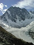
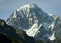
The Aiguille des Glaciers (3,816 m) is a mountain in the Mont Blanc massif of the Graian Alps. It lies on the borders of Savoie and Haute-Savoie in France and Aosta Valley in Italy.

A fine pyramidal peak when seen to the south from the Italian side, Aiguille des Glaciers dominates the view from the upper Veny Valley, although it is less distinct from its French side. It is usually climbed from the Vallee des Glaciers in Savoie. The view from its summit is one of the best in the entire area. [2]

On 1 November 1946, a B-17 Flying Fortress of the US Airforce crashed into the Aiguille des Glaciers, just 66 meters below the summit of Mont Blanc, killing all eight crew members. The crash site was not discovered until July 1947, when remains were found at an altitude of 3,700 metres (12,000 ft). [3]

See also

Related Research Articles

<span class="mw-page-title-main">Mont Blanc</span> Highest mountain in the Alps (4,808 m)

Mont Blanc is the highest mountain in the Alps and Western Europe, and the highest mountain in Europe outside the Caucasus mountains, rising 4,805.59 m (15,766 ft) above sea level, located on the French-Italian border. It is the second-most prominent mountain in Europe, after Mount Elbrus, and the 11th most prominent mountain in the world.

<span class="mw-page-title-main">Chamonix</span> Commune in Auvergne-Rhône-Alpes, France

Chamonix-Mont-Blanc, more commonly known simply as Chamonix (Chamôni), is a commune in the Haute-Savoie department in the Auvergne-Rhône-Alpes region in Southeastern France. It was the site of the first Winter Olympics, held in 1924.

<span class="mw-page-title-main">Aiguille de Bionnassay</span> Mountain in the Mont Blanc massif

The Aiguille de Bionnassay is a mountain in the Mont Blanc massif of the Alps in France and Italy. It has been described as "one of the most attractive satellite peaks of Mont Blanc", and is located on its western side. The mountain's south and east ridges form the frontier between the two countries, and its summit is a knife-edge crest of snow and ice. Reaching it via any route provides a "splendid and serious snow and ice climb".

<span class="mw-page-title-main">Aiguille du Midi</span> Mountain in the French Alps

The Aiguille du Midi is a 3,842-metre-tall (12,605 ft) mountain in the Mont Blanc massif within the French Alps. It is a popular tourist destination and can be directly accessed by cable car from Chamonix that takes visitors close to Mont Blanc.

<span class="mw-page-title-main">Les Contamines-Montjoie</span> Commune in south-eastern France

Les Contamines-Montjoie is a commune in the Haute-Savoie department in the Auvergne-Rhône-Alpes region in south-eastern France.

<span class="mw-page-title-main">Mont Blanc massif</span> Mountain range in the Alps

The Mont Blanc massif is a mountain range in the Alps, located mostly in France and Italy, but also straddling Switzerland at its northeastern end. It contains eleven major independent summits, each over 4,000 metres (13,123 ft) in height. It is named after Mont Blanc, the highest point in western Europe and the European Union. Because of its considerable overall altitude, a large proportion of the massif is covered by glaciers, which include the Mer de Glace and the Miage Glacier – the longest glaciers in France and Italy, respectively.

<span class="mw-page-title-main">Vanoise massif</span> Mountain range in the Western Alps

The Vanoise massif is a mountain range of the Graian Alps, located in the Western Alps. After the Mont Blanc Massif and the Écrins Massif it is the third-highest massif in France, reaching a height of 3,885 m at the summit of Grande Casse. It lies between Tarentaise Valley to the north and the Maurienne Valley in the south. The range is the site of France's first national park, established in 1963, Vanoise National Park. The ski resorts of Tignes and Val-d'Isère and the 2,770-metre-high Col de l'Iseran are located in the eastern part of the range.

<span class="mw-page-title-main">Torino Hut</span> Mountain refuge in the Alps

The Torino Hut is a high mountain refuge in the Alps in northwestern Italy. Located near the border with France, it is about 15 km (10 mi) southwest of Mont Dolent, the tripoint with Switzerland. The refuge is in the Mont Blanc massif above the town of Courmayeur in the Aosta Valley, Italy. It can be most easily accessed from the Italian side by the Skyway Monte Bianco cable car from La Palud in Courmayeur, with a change at the Pavilion du Mont Fréty. It can also be reached from Chamonix via the Aiguille du Midi, either by cable car which crosses the massif, or by a long crossing of the Glacier du Gèant. The refuge lies nearly directly above the 11.6 km (7.2 mi) Mont Blanc Tunnel, which passes deep underground, and connects Courmayeur to Chamonix.

<span class="mw-page-title-main">Aiguille du Belvédère</span>

Aiguille du Belvédère is a mountain of Haute-Savoie, France. It is the highest peak in the Aiguilles Rouges range of the French Prealps and has an altitude of 2,965 metres (9,728 ft) above sea level.

<span class="mw-page-title-main">Aiguille du Chardonnet</span> Mountain in the Mont Blanc massif in Haute-Savoie, France

The Aiguille du Chardonnet is a mountain in the Mont Blanc massif in Haute-Savoie, France. It lies between the Glacier du Tour and the Argentière Glacier. The border with Switzerland runs just east of the summit. The East or Forbes Arete provides a popular and classic mountaineering route to the summit.

<span class="mw-page-title-main">Aiguille des Grands Charmoz</span> Mountain in the Mont Blanc Massif in Haute-Savoie, France

The Aiguille des Grands Charmoz is a mountain in the Mont Blanc Massif in Haute-Savoie, France.

<span class="mw-page-title-main">Mont Buet</span> Mountain in Chablais Alps

The Mont Buet is a mountain of the Chablais Alps in Haute-Savoie, France. Mont Buet has played an important role in the history of science at the end of the eighteenth century when a series of Genevan scientists such as Jean-André Deluc, Horace Bénédict de Saussure or Marc-Auguste Pictet climbed to the summit to carry out scientific observations. Before the first successful ascents on the Mont Blanc in 1786, Mont Buet was "the highest among those accessible in this area" of the Alps. Mont Buet remains a popular destination especially because of the exceptional view on Mont Blanc, and the panoramic view from the summit.

<span class="mw-page-title-main">Aiguille du Plan</span> Mountain in the Mont Blanc massif in the French Alps

The Aiguille du Plan is a mountain in the Mont Blanc massif in the French Alps. Its needle-like summit lies in the centre of the Chamonix Aiguilles when viewed from Chamonix.

<span class="mw-page-title-main">Aiguille de Triolet</span> Mountain on the Mont Blanc massif

The Aiguille de Triolet is a mountain on the eastern part the Mont Blanc massif, on the border between France and Italy.

<span class="mw-page-title-main">Aiguille de Leschaux</span> Mountain in Italy

Aiguille de Leschaux is a mountain in the Mont Blanc massif on the border of Haute-Savoie, France and Aosta Valley, Italy.

<span class="mw-page-title-main">Goûter Hut</span> Mountain refuge in the French department of Haute-Savoie

The Goûter Hut, is a mountain refuge in the French department of Haute-Savoie. It is located at a height of 3,835 metres (12,582 ft) on the Arete du Goûter in the municipality of Saint-Gervais-les-Bains. It overlooks the Glacier de Bionnassay, and is the highest wardened mountain hut in France.

<span class="mw-page-title-main">Goûter Route</span> Mountain route to reach Mont Blanc summit

The Goûter Route is one of the two normal mountaineering routes used to reach the summit of Mont Blanc in the Alps, ascending to a height of 4,808 metres (15,774 ft). The route lies on the north side of the mountain, in France. Usually reckoned as the easiest route up Mont Blanc, it is extremely popular with mountaineers, seeing thousands of ascents per year.

<span class="mw-page-title-main">Aiguilles d'Entrèves</span> Mountain peak in the Mont Blanc massif of the Alps

The Aiguilles d'Entrèves is a mountain peak in the Mont Blanc massif of the Alps. It is situated at the head of the Glacier du Géant, and its rocky summit ridge forms part of the frontier between France and Italy. It lies east of the Tour Ronde, between the Col d'Entrèves and the Col Occidental de Toule. It has a steep, sound face of red granite and can be readily accessed from the Torino Hut/Pointe Helbronner.

<span class="mw-page-title-main">Grand Flambeau</span> Mountain peak in the Mont Blanc massif

The Grand Flambeau is a mountain peak in the Mont Blanc massif of the Alps. It is situated at the head of the Géant Glacier, approximately 0.5 km (0.31 mi) east of the Aiguille de Toule, between the Col Orientale de Toule and the Col de Saussure.

<span class="mw-page-title-main">Aiguille de Toule</span> Mountain peak in the Mont Blanc massif

The Aiguille de Toule is a mountain peak in the Mont Blanc massif of the Alps. Its summit is one of a number which form part of the mountainous frontier ridge between France and Italy which descends eastwards from Mont Blanc and continues towards the Grandes Jorasses and Mont Dolent.

References

  1. "Aiguille des Glaciers". peakvisor.com. Retrieved 8 November 2019.
  2. "Summitpost - Aiguille des Glaciers". Summitpost.org. Retrieved 6 November 2019.
  3. "Overview". B17 MontBlanc. Committee for the Commemoration of the B17 of the Aiguille des Glaciers. Archived from the original on 11 November 2020. Retrieved 15 June 2016.