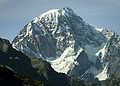
It is situated on the southwest flank of the Mont Blanc massif, flowing from the Bionnassay Pass (3,892m (12,769ft)above sea level) in a generally southerly direction towards Val Veny. Its most northerly arm or tributary is the Glacier de Bionnassay italien, which arises from a cirque between the south eastern side of the Aiguille de Bionnassay, the Col de Bionnassay and the Calotte des Aiguille Grises. This descends for 2.5km below the Col Infranchissable then turns south-east to merge with other glaciers, thence continuing as the Miage glacier.
At around 10km (6.2mi) in length, the Miage Glacier is Italy's longest glacier and also the largest debris-covered glacier in Europe.[1][2] Approximately 5km2 (1.9sqmi) of its total area of ~11km2 (4.2sqmi) is covered in debris originating primarily in rockfall from surrounding walls[3] and avalanching in accumulation areas of its four tributaries.[4] Debris carried along within the glacier is also being exposed at increased rates due to accelerating thinning of the glacier tongue.[4]
The number of sources of supraglacial debris as well as the unusual, mica schist-dominated lithology of the rock walls surrounding the glacier, makes for a varied debris lithology; debris cover becomes continuous at ~2,400m (7,900ft) above mean sea level (asl) and remains unbroken to the terminus. Patchy areas can occur, however, where crevasses or moulins occur.[4] Debris thickness generally increases from a few centimetres at 2,400m (7,900ft) asl to over 1 metre (3ft 3in) at the terminus at ~1,775m (5,823ft) asl, although the spatial distribution of thicknesses is heterogeneous especially on parts of the northern terminal lobe.[5]
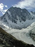
Miage Lake
View of Miage Lake from the west, summer 2010
Miage Lake is a proglacial lake near the southern end of the Miage Glacier, located on the outside of the glacier's 90-degree bend eastwards.[6] It is a popular tourist attraction due to the spectacular ice cliffs rising up to one side and its two-coloured appearance. The colours reflect varying sediment concentrations in the water which arise as a result of the filtering effect of the debris.[7]
Huge ice blocks have been known to break off the glacier and fall into the lake, providing another major tourist attraction despite the low chance of such an event occurring. On August 9, 1996, a particularly large block, estimated to have had a volume of 7000-16000m3, fell into the lake causing an abnormally large wave that seriously injured several people.[8] The incident was caught on camera by at least one tourist.
123Mihalcea, C.; Brock, B.; Diolaiuti, G.; Dagata, C.; Citterio, M.; Kirkbride, M.; Cutler, M.; Smiraglia, C. (2008). "Using ASTER satellite and ground-based surface temperature measurements to derive supraglacial debris cover and thickness patterns on Miage Glacier (Mont Blanc Massif, Italy)". Cold Regions Science and Technology. 52: 341. doi:10.1016/j.coldregions.2007.03.004.
↑Masetti, M.; Diolaiuti, G.; D’agata, C.; Smiraglia, C. (2009). "Hydrological Characterization of an Ice-Contact Lake: Miage Lake (Monte Bianco, Italy)". Water Resources Management. 24 (8): 1677. doi:10.1007/s11269-009-9519-x.
↑Tinti, S.; Maramai, A.; Cerutti, A. (1999). "The Miage Glacier in the Valley of Aosta (Western Alps, Italy) and the extraordinary detachment which occurred on August 9, 1996". Physics and Chemistry of the Earth, Part A: Solid Earth and Geodesy. 24 (2): 157. Bibcode:1999PCEA...24..157T. doi:10.1016/S1464-1895(99)00012-5.
This page is based on this Wikipedia article Text is available under the CC BY-SA 4.0 license; additional terms may apply. Images, videos and audio are available under their respective licenses.