
Mont Blanc or White Mountain is the second-highest mountain in Europe after Mount Elbrus. It is the highest mountain in the Alps, rising 4,808 m (15,774 ft) above sea level. It is the eleventh-most prominent peak in the world. The mountain stands in a range called the Graian Alps, between the regions of Aosta Valley, Italy, and Savoie and Haute-Savoie, France. The location of the summit is on the watershed line between the valleys of Ferret and Veny in Italy and the valleys of Montjoie, and Arve in France, on the border between the two countries.

Chamonix-Mont-Blanc, more commonly known as Chamonix, is a commune in the Haute-Savoie department in the Auvergne-Rhône-Alpes region in south-eastern France. It was the site of the first Winter Olympics in 1924.

The Aiguille de Bionnassay is a mountain in the Mont Blanc massif of the Alps in France and Italy. It has been described as "one of the most attractive satellite peaks of Mont Blanc", and is located on its western side. The mountain's south and east ridges form the frontier between the two countries, and its summit is a knife-edge crest of snow and ice. Reaching it via any route provides a "splendid and serious snow and ice climb".

The Grand Combin is a mountain massif in the western Pennine Alps in the canton of Valais. With its 4,314 metres (14,154 ft) highest summit, the Combin de Grafeneire, it is one of the highest peaks in the Alps and the second most prominent of the Pennine Alps. The Grand Combin is also a large glaciated massif consisting of several summits, among which three are above 4000 metres. The highest part of the massif is wholly in Switzerland, although the border with Italy lies a few kilometres south.

The Barre des Écrins is a mountain in the French Alps with a peak at 4102m altitude. It is the highest peak of the Massif des Écrins and the Dauphiné Alps and the most southerly alpine peak in Europe that is higher than 4,000 m. It is the only 4,000 m mountain in France that lies outside the Mont Blanc Massif. Before the annexation of Savoy in 1860 it was the highest mountain in France.

The Mont Blanc massif is a mountain range in the Alps, located mostly in France and Italy, but also straddling Switzerland at its northeastern end. It contains eleven major independent summits, each over 4,000 metres (13,123 ft) in height. It is named after Mont Blanc, the highest point in western Europe and the European Union. Because of its considerable overall altitude, a large proportion of the massif is covered by glaciers, which include the Mer de Glace and the Miage Glacier – the longest glaciers in France and Italy, respectively.

The Dent du Géant is a mountain in the Mont Blanc massif in France and Italy.

Mont Maudit is a mountain in the Mont Blanc massif in France and Italy. The French name literally means "Cursed Mountain". Until the end of the 18th century, Mont Blanc and its satellite peaks were collectively known in French as the Montagne Maudite.

Mont Blanc du Tacul is a mountain in the Mont Blanc massif of the French Alps situated midway between the Aiguille du Midi and Mont Blanc.

The Aiguille Blanche de Peuterey is a mountain of the Mont Blanc massif in Italy. It is considered the most difficult and serious of the alpine 4000-m mountains to climb.

Mont Blanc de Courmayeur is a point on the south-east ridge of Mont Blanc that forms the peak of the massive south-east face of the mountain. It is connected to the main summit via the Col Major.

Les Droites is a mountain in the Mont Blanc massif in the French Alps and is the lowest of the 4000-metre peaks in the Alps. The mountain has two summits:

Picco Luigi Amedeo is a mountain in the Mont Blanc massif in the Val d'Aosta, Italy. It lies on the Brouillard ridge to the summit of Mont Blanc.

The Grand Pilier d'Angle is a buttress on the southern side of Mont Blanc in the Mont Blanc massif in the Aosta Valley, Italy.

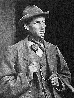
James Eccles FGS was an English mountaineer and geologist who is noted for making a number of first ascents in the Alps during the silver age of alpinism.
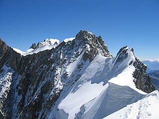
The Aiguille de Rochefort is a mountain in the Mont Blanc massif in France and Italy. The peak lies on the Rochefort arête between the Dent du Géant and the Grandes Jorasses and is usually climbed during a traverse of the ridge.
Émile Rey was an alpine mountain guide from Aosta Valley in Italy. Dubbed "the Prince of Guides" in Courmayeur, he was one of the most renowned guides at the end of the 19th century, making many first ascents on some of the highest and most difficult mountains in the Mont Blanc massif of the Alps. He has been described as "one of the greatest guides of his generation."
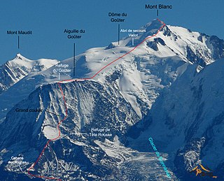
The Goûter Route is one of the two normal mountaineering routes used to reach the summit of Mont Blanc in the Alps, ascending to a height of 4,808 metres (15,774 ft). The route lies on the north side of the mountain, in France. Usually reckoned as the easiest route up Mont Blanc, it is extremely popular with mountaineers, seeing thousands of ascents per year.

Ulrich Almer was a Swiss mountain guide, born on 8 May 1849 in Grindelwald where he died on 4 September 1940. He made many premieres in the Alps, at the beginning with his father Christian Almer, one of the great guides of the golden age of mountaineering, and was one of the first Swiss guides to visit the Caucasus.


