
The Finsteraarhorn is a mountain lying on the border between the cantons of Bern and Valais. It is the highest mountain of the Bernese Alps and the most prominent peak of Switzerland. The Finsteraarhorn is the ninth-highest mountain and third-most prominent peak in the Alps. In 2001 the whole massif and surrounding glaciers were designated as part of the Jungfrau-Aletsch World Heritage Site.

The Grünhorn is a mountain in the Bernese Alps range of the Swiss Alps. It is located on the ridge between the two largest glaciers of the Alps: the Aletsch Glacier to the west and the Fiescher Glacier to the east. To the south lies the Gross Wannenhorn and, to the north, the Gross Fiescherhorn.

Grosses Fiescherhorn is a mountain peak of the Bernese Alps, located on the border between the cantons of Bern and Valais, halfway between the Mönch and the Finsteraarhorn. At 4,049 metres (13,284 ft) above sea level, its summit culminates over the whole Fiescherhorn massif, which is also composed of the slightly lower Hinteres Fiescherhorn to the south and Kleines Fiescherhorn to the east. From the north both are well hidden behind other mountain peaks and can only been seen from Isch in Grindelwald. The mountain is shared between the municipalities of Grindelwald and Fieschertal.

The Grand Combin is a mountain massif in the western Pennine Alps in the canton of Valais. At a height of 4,309 metres (14,137 ft) the summit of Combin de Grafeneire is one of the highest peaks in the Alps and the second most prominent of the Pennine Alps. The Grand Combin is also a large glaciated massif consisting of several summits, among which three are above 4000 metres. The highest part of the massif is wholly in Switzerland, although the border with Italy lies a few kilometres south.

The Weissmies 4,013 m (13,166 ft) is a mountain in the Pennine Alps in the canton of Valais in Switzerland near the village of Saas-Fee. It is the easternmost four-thousander of its range.

The Allalinhorn is a mountain in the Pennine Alps in Switzerland. It lies between Zermatt and Saas-Fee in the canton of Valais, and is part of the Mischabel range, which culminates at the Dom.

The Schreckhorn is a mountain in the Bernese Alps. It is the highest peak located entirely in the canton of Bern. The Schreckhorn is the northernmost Alpine four-thousander and the northernmost summit rising above 4,000 metres in Europe.

The Nadelhorn is a mountain in the Pennine Alps in Switzerland. It is the highest point on the Nadelgrat, a high-level ridge running roughly north–south above the resort of Saas-Fee to the east, and the Mattertal to the west. Its three ridges join to form a sharp-pointed summit, which looks like a needle when seen from the north. The other summits on the Nadelgrat are the Stecknadelhorn and Hohberghorn.

The Strahlhorn is a mountain of the Swiss Pennine Alps, located south of Saas-Fee and east of Zermatt in the canton of Valais. It lies on the range that separates the Mattertal from the Saastal and is located approximately halfway between the Rimpfischhorn and the Schwarzberghorn.

The Zinalrothorn is a mountain in the Pennine Alps in Switzerland. Its name comes from the village of Zinal lying on the north side and from the German word Rothorn which means Red Peak. When it was first climbed in 1864 the mountain was known locally as Moming.

The Rimpfischhorn is a mountain in the Pennine Alps of Switzerland. Along its north ridge lies the prominent sub-peak Grosser Gendarm.

The Dent du Géant is a mountain in the Mont Blanc massif in France and Italy.

Mont Blanc du Tacul is a mountain in the Mont Blanc massif of the French Alps situated midway between the Aiguille du Midi and Mont Blanc.

The Aiguille Blanche de Peuterey is a mountain of the Mont Blanc massif in Italy. It is considered the most difficult and serious of the alpine 4000-m mountains to climb.

Les Droites is a mountain in the Mont Blanc massif in the French Alps and is the lowest of the 4000-metre peaks in the Alps. The mountain has two summits:
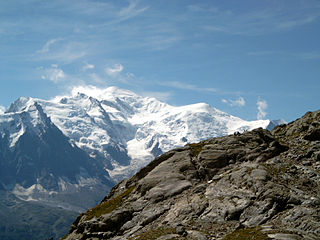
The Dôme du Goûter is a mountain in the Mont Blanc massif. It is a shoulder of Mont Blanc, whose summit lies two kilometres to the south-east. The Dôme is traversed on ascents of Mont Blanc via the Bosses route.

The Aiguille du Jardin is a summit on the east ridge of Aiguille Verte in the Mont Blanc massif in Haute-Savoie, France.
The Dôme de Rochefort is a mountain in the Mont Blanc massif in Haute-Savoie, France and of Aosta Valley, Italy.
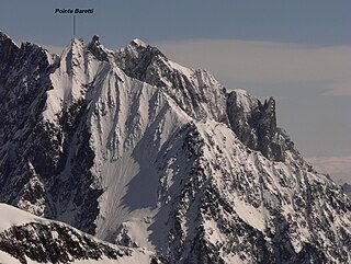
Punta Baretti is a mountain in the Mont Blanc Massif in the Val d'Aosta, Italy.


