Pointe-à-Pitre is the largest city of Guadeloupe, an overseas région and département of France located in the Lesser Antilles, of which it is a sous-préfecture, being the seat of the Arrondissement of Pointe-à-Pitre.

La Dôle is a mountain of the Jura, overlooking Lake Geneva in the westernmost part of the canton of Vaud. Rising to an altitude of 1677 meters, it is the second highest peak in the Swiss portion of the Jura, after Mont Tendre. Administratively, the summit is split between the municipalities of Gingins, Chéserex and La Rippe. The mountain is also close to and easily accessible from Saint-Cergue and the Col de la Givrine to the north, both above 1000 meters and connected to Nyon on Lake Geneva by road and by the Nyon–St-Cergue–Morez Railway. A paved road also climbs to the Chalet de la Dôle below the summit from Gingins.

The Vanoise massif is a mountain range of the Graian Alps, located in the Western Alps. After the Mont Blanc Massif and the Massif des Écrins it is the third highest massif in France, reaching a height of 3,885m at the summit of Grande Casse. It lies between Tarentaise Valley to the north and the Maurienne valley in the south. The range is the site of France's first National Park in 1963, the Vanoise National Park. The ski resorts of Tignes and Val-d'Isère and the 2,770m high Col de l'Iseran are located in the eastern part of the range.

Michel Auguste Croz was a French mountain guide and the first ascentionist of many mountains in the western Alps during the golden age of alpinism. He is chiefly remembered for his death on the first ascent of the Matterhorn and for his climbing partnership with Edward Whymper.

The Aiguille de la Tsa is a mountain of the Swiss Pennine Alps, overlooking Arolla in the canton of Valais. It lies on the range culminating at the Dent de Perroc, between the valley of Arolla and the Mont Miné Glacier.

The Tsa de l'Ano is a mountain of the Swiss Pennine Alps, located east of Les Haudères in the canton of Valais. It is separated by the Col de Mourti from the Pointes de Mourti to the southeast, on the range between the valley of Hérens and the Moiry Glacier . To the north of the main summit is the secondary peak of Pointe de Moiry, which is separated by the Col de la Couronne from the Couronne de Bréona.
The Grande Pointe des Planereuses is a mountain of the Mont Blanc massif, located west of Praz de Fort in the canton of Valais, Switzerland. It lies on the range south of the Saleina Glacier.
The Pointe de Bertol is a mountain of the Swiss Pennine Alps, located south of Arolla in the canton of Valais. On its southern side it overlooks the Bertol Pass.

The Île Ronde is a French islet 400 metres (0.25 mi) to the south west of Pointe de l’Armorique, in the roadstead of Brest, within the territory of the commune of Plougastel-Daoulas. Its highest point is 24 m. Facing Île Ronde, on the pointe de l’Armorique, is the fort de la pointe de l’Armorique, built in 1775 for the defense of Brest.

José Flober Peña Peña is a professional road racing cyclist from Colombia. He was nicknamed "Donatelo" during his career.
The Commission scolaire de la Pointe-de-l'Île (CSPÎ) is a francophone school board in Montreal, Quebec, Canada, based primarily in the city's east end. It serves Montréal-Nord, Saint-Léonard, Anjou, and Rivière-des-Prairies–Pointe-aux-Trembles. It also serves Montréal-Est, a municipality outside of the Montreal city limits. Its headquarters is in the Pointe-aux-Trembles area of Montreal.
The Bornes Massif is a mountainous massif in the north French Prealps in the département of Haute-Savoie. It has 20 peaks higher than 2000 m and is a popular destination for winter sports. The Massif is the source of the celebrated cheese Reblochon.

The B-10, also known as Ronda Litoral, is a 20-kilometre (12.43 mi) freeway in Catalonia, Spain partially encircling Barcelona passing through the eastern side of the city. It starts at Nus de la Trinitat interchange in northern Barcelona and runs along the entire length of the Besòs River and the city's coastline south to Nus del Llobregat interchange in Barcelona's southern suburbs, where it becomes the Autovía A-2. Both north and south end interchanges link the freeway to the B-20 or Ronda de Dalt, which encircles Barcelona passing through the western side, jointly forming a beltway commonly referred to as the rondes that surrounds the city.

The Pointe de la Plaine Morte is a mountain of the Bernese Alps, located on the border between the Swiss cantons of Bern and Valais. It overlooks the large and flat glacier named Plaine Morte Glacier, from the south-west side.

The Pointe de la Gorgeat is a Chartreuse Mountain culminating at 1,486 m above sea level in the French department of Savoie.
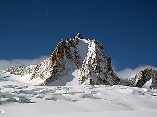
The Tour Ronde is a mountain in the Mont Blanc massif of the Alps, situated on the border between France and Italy. It is a prominent mountain, some 3.5 km north-east of Mont Blanc, but is effectively part of a continuation of the south eastern spur of Mont Maudit which forms a frontier ridge between the two countries. It is easily accessible to mountaineers and provides not only a very good viewpoint from its summit of the Brenva face and the major peaks on the southern side of Mont Blanc, but it also offers a popular introduction to alpine climbing of all grades, including a north face ascent.
The Col du Géant at 3,356 meters is the main passage of the Mont Blanc massif between Courmayeur in the Aosta Valley and Chamonix-Mont Blanc in the Arve Valley. On the French side, to the north is the Géant Glacier which overlooks the Mer de Glace.

The Aiguilles d'Entrèves is a mountain peak in the Mont Blanc massif of the Alps. It is situated at the head of the Glacier du Géant, and its rocky summit ridge forms part of the frontier between France and Italy. It lies east of the Tour Ronde, between the Col d'Entrèves and the Col Occidental de Toule. It has a steep, sound face of red granite and can be readily accessed from the Torino Hut/Pointe Helbronner.
The Pointe Rochers Charniers is a mountain of the Cottian Alps at an elevation of 3,063 metres above sea level, located in France.