The Allobroges were a Gallic people dwelling in a large territory between the Rhône river and the Alps during the Iron Age and the Roman period.
The Grandes Jorasses is a mountain in the Mont Blanc massif, on the boundary between Haute-Savoie in France and Aosta Valley in Italy.
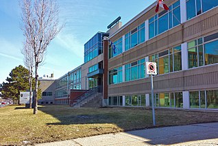
The Centre de services scolaire Marguerite-Bourgeoys is an autonomous school service centre on Montreal Island, Quebec, Canada, appointed by the Ministry of Education.

The Dent du Géant is a mountain in the Mont Blanc massif in France and Italy.

The Vanoise massif is a mountain range of the Graian Alps, located in the Western Alps. After the Mont Blanc Massif and the Écrins Massif it is the third-highest massif in France, reaching a height of 3,885 m at the summit of Grande Casse. It lies between Tarentaise Valley to the north and the Maurienne Valley in the south. The range is the site of France's first national park, established in 1963, Vanoise National Park. The ski resorts of Tignes and Val-d'Isère and the 2,770-metre-high Col de l'Iseran are located in the eastern part of the range.

Michel Auguste Croz was a Chamoniard mountain guide of the Kingdom of Sardinia and the first ascentionist of many mountains in the western Alps during the golden age of alpinism. He is chiefly remembered for his death on the first ascent of the Matterhorn and for his climbing partnership with Edward Whymper.
The Pointe d'Orny is a mountain of the Mont Blanc massif, located west of Orsières in the canton of Valais. It lies north-east of the Plateau du Trient.
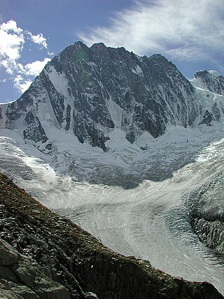
The Pointe des Grands is a mountain of the Mont Blanc Massif, located on the border between France and Switzerland, north-west of the Aiguille du Tour.
The Pointe des Berons is a mountain of the Mont Blanc Massif, located on the border between Switzerland and France. It lies approximately halfway between the Col de Balme and the Aiguille du Tour. The east (Swiss) side is covered by the Glacier des Berons.
The Pointe Ronde is a mountain of the Mont Blanc massif, overlooking Trient in the canton of Valais. It lies near the northern end of the Arête de la Lys, the ridge descending in a north-westerly direction from the Génépi towards the Col de la Forclaz.
The Pointe des Plines is a minor peak on the east edge of the Mont Blanc massif, close to the Aiguille Dorees, and overlooking the Saleina Glacier in the canton of Valais.
The Pointe de Barasson is a mountain of the Swiss Pennine Alps, located on the border between Switzerland and Italy. It lies between the Great St Bernard Pass and Mont Vélan.
The Grande Pointe des Planereuses is a mountain of the Mont Blanc massif, located west of Praz de Fort in the canton of Valais, Switzerland. It lies on the range south of the Saleina Glacier.

The Petite Pointe d'Orny is a mountain of the Mont Blanc Massif, overlooking the Trient Glacier in the canton of Valais. It lies north of the Pointe d'Orny.

Pointe Kurz is a mountain of the Mont Blanc Massif, located on the border between France and Switzerland. It lies between the glaciers of Argentière and L'A Neuve, west of La Fouly, the closest locality.
The Pointe des Ecandies is a mountain of the Mont Blanc Massif, located between Trient and Champex in the canton of Valais. It is located north of the Pointe d'Orny and east of the Trient Glacier.
The Bornes Massif is a mountainous massif in the north French Prealps in the département of Haute-Savoie. It has 20 peaks higher than 2000 m and is a popular destination for winter sports. The Massif is the source of the celebrated cheese Reblochon.

The Pointe de la Plaine Morte is a mountain of the Bernese Alps, located on the border between the Swiss cantons of Bern and Valais. It overlooks the large and flat glacier named Plaine Morte Glacier, from the south-west side.

The Pointe de Bellecombe is a 2,775 m high mountain of the northern Cottian Alps.

Les Périades is a sharp and heavily-pinnacled mountain ridge, stretching for over 1,500 metres (0.93 mi) in the Mont Blanc massif in Haute-Savoie, France. It runs in a southerly direction from the Col du Tacul to the Col du Mont Mallet. Its highest point is Pointe Cupelin


