
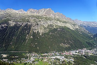
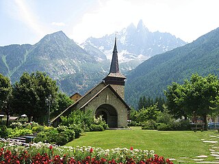
Chamonix-Mont-Blanc, more commonly known as Chamonix, is a commune in the Haute-Savoie department in the Auvergne-Rhône-Alpes region of southeastern France. It was the site of the first Winter Olympics in 1924. In 2019, it had a population of 8,640.
Argentière is a picturesque skiing, alpine walking and mountaineering village in the French Alps, part of the commune of Chamonix-Mont-Blanc, at an altitude of 1,252 m (4,108 ft).
The Aiguille du Midi is a 3,842-metre-tall (12,605 ft) mountain in the Mont Blanc massif within the French Alps. It is a popular tourist destination and can be directly accessed by cable car from Chamonix that takes visitors close to Mont Blanc.
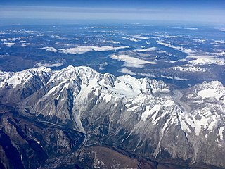
The Mont Blanc massif is a mountain range in the Alps, located mostly in France and Italy, but also straddling Switzerland at its northeastern end. It contains eleven major independent summits, each over 4,000 metres (13,123 ft) in height. It is named after Mont Blanc, the highest point in western Europe and the European Union. Because of its considerable overall altitude, a large proportion of the massif is covered by glaciers, which include the Mer de Glace and the Miage Glacier – the longest glaciers in France and Italy, respectively.

The Aiguille Verte, which is French for "Green Needle", is a mountain in the Mont Blanc massif in the French Alps.
The Aiguilles Rouges are a crystalline mountainous massif of the French Prealps, opposite the Mont Blanc Massif. The colour of the iron rich gneiss (metamorphique) mountains gives the range its name. The highest summit is the Aiguille du Belvédère at 2,965 metres (9,728 ft). At the southern end of the range, Le Brévent at 2,525 metres (8,284 ft) is accessible by a cable car in the Planpraz and the Brévent sections.
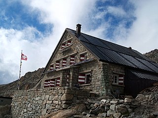
The Trient hut is a mountain hut in the Swiss alps, near the Swiss town of Martigny and the French town of Chamonix. The hut sits at an altitude of 3,170 m (10,400 ft), on a rock perched above the Trient Glacier. It can be reached on foot by mountaineers and strong hikers with experience of glacier travel. From the hut you can walk to the Albert Premier and Argentière huts in France, as well as the Cabane de Saleina (Switzerland) at the foot of the Aiguille d'Argentière. The hut is run by the SAC, the Swiss Alpine Club, and has 130 beds. It is a popular base for mountaineers exploring the area, e.g. Aiguille du Tour etc.
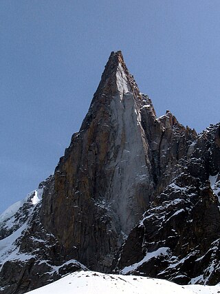
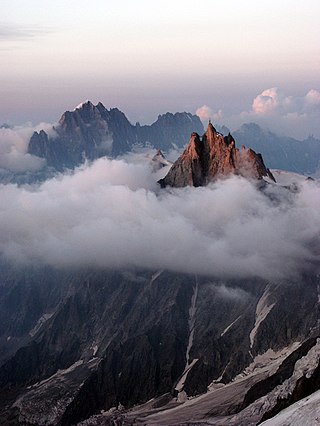
The Aiguille du Dru is a mountain in the Mont Blanc massif in the French Alps. It is situated to the east of the village of Les Praz in the Chamonix valley. "Aiguille" means "needle" in French.
Les-Praz-de-Chamonix is a mountain village in the French Alps, part of the commune of Chamonix. Altitude: 1060 m (3477 ft.).
The Piste de Bobsleigh des Pellerins was a bobsleigh track constructed for the 1924 Winter Olympics in Chamonix, France.

The Albert Premier Hut, sometimes known as Albert 1er, is located on the Haute Route between Chamonix, France and Zermatt, Switzerland. It is at 2,702 metres (8,865 ft) above sea level. It is a popular hut with day hikers because of the short hike and views of Chamonix Valley. The hut is usually used less by hikers attempting the entire Haute Route, but is popular as a base for climbers attempting the Aiguille du Chardonnet and the Aiguille du Tour. The hut is named after King Albert I of Belgium, who was a passionate alpinist.

The Aiguilles Dorées are a multi-summited mountain of the Mont Blanc massif, overlooking the Plateau du Trient in the canton of Valais. They lie east of the Petite Fourche, on the range between the glaciers of Trient and Saleina.
Pointe Helbronner is a mountain in the Mont Blanc massif in the Graian Alps on the watershed between France and Italy.

The Torino Hut is a high mountain refuge in the Alps in northwestern Italy. Located near the border with France, it is about 15 km (10 mi) southwest of Mont Dolent, the tripoint with Switzerland. The refuge is in the Mont Blanc massif above the town of Courmayeur in the Aosta Valley, Italy. It can be most easily accessed from the Italian side by the Skyway Monte Bianco cable car from La Palud in Courmayeur, with a change at the Pavilion du Mont Fréty. It can also be reached from Chamonix via the Aiguille du Midi, either by cable car which crosses the massif, or by a long crossing of the Glacier du Gèant. The refuge lies nearly directly above the 11.6 km (7.2 mi) Mont Blanc Tunnel, which passes deep underground, and connects Courmayer to Chamonix.

Aiguille du Belvédère is a mountain of Haute-Savoie, France. It is the highest peak in the Aiguilles Rouges range of the French Prealps and has an altitude of 2,965 metres (9,728 ft) above sea level.
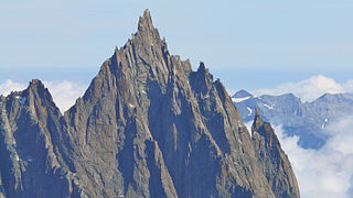
The Aiguille du Grépon, informally known as The Grepon, is a mountain in the Mont Blanc Massif in Haute-Savoie, France. The Grepon has a Southern and Northern peak, which are the highest points of a sharp granite ridge to the east of the Glacier des Nantillons above Chamonix and northeast of the Aiguille du Midi. A madonna statue is situated on the Southern peak.

The Aiguilles Rouges National Nature Reserve is a nature reserve located in the Aiguilles Rouges mountain range in the Haute-Savoie department in southeastern France.

Armand Charlet was a French mountaineer and mountain guide.

The Marathon du Mont Blanc is an annual marathon distance (42.195 km) alpine trail running event held in Chamonix, France. The Marathon du Mont Blanc race is the titular event but the name also refers to the group of longer and shorter distance races one or more of which competitors can compete in over a three-day period starting on the last Friday in June.

Chamonix-Aiguille-du-Midi station is a railway station in the commune of Chamonix-Mont-Blanc, in the French department of Haute-Savoie. It is located on the 1,000 mm gauge Saint-Gervais–Vallorcine line of SNCF.


