
Mont Blanc is the highest mountain in the Alps and Western Europe, and the highest mountain in Europe outside the Caucasus Mountains, rising 4,805.59 m (15,766 ft) above sea level, located on the Franco-Italian border. It is the second-most prominent mountain in Europe, after Mount Elbrus, and the 11th most prominent mountain in the world.

The Dufourspitze is the highest peak of Monte Rosa, an ice-covered mountain massif in the Alps. Dufourspitze is the highest mountain of both Switzerland and the Pennine Alps and is also the second-highest mountain of the Alps and Western Europe, after Mont Blanc. It is located between Switzerland and Italy. The peak itself is located wholly in Switzerland.

The Aiguille de Bionnassay is a mountain in the Mont Blanc massif of the Alps in France and Italy. It has been described as "one of the most attractive satellite peaks of Mont Blanc", and is located on its western side. The mountain's south and east ridges form the frontier between the two countries, and its summit is a knife-edge crest of snow and ice. Reaching it via any route provides a "splendid and serious snow and ice climb".
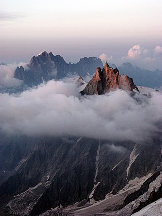
The Aiguille du Midi is a 3,842-metre-tall (12,605 ft) mountain in the Mont Blanc massif within the French Alps. It is a popular tourist destination and can be directly accessed by cable car from Chamonix that takes visitors close to Mont Blanc.

Walter Bonatti was an Italian mountaineer, alpinist, explorer and journalist. He was noted for many climbing achievements, including a solo climb of a new alpine climbing route on the south-west pillar of the Aiguille du Dru in August 1955, the first ascent of Gasherbrum IV in 1958, and, in 1965, the first solo climb in winter of the North face of the Matterhorn on the mountain's centenary year of its first ascent. Immediately after his solo climb on the Matterhorn, Bonatti announced his retirement from professional climbing at the age of 35, and after 17 years of climbing activity. He authored many mountaineering books and spent the remainder of his career travelling off the beaten track as a reporter for the Italian magazine Epoca. He died on 13 September 2011 of pancreatic cancer in Rome aged 81, and was survived by his life partner, the actress Rossana Podestà.
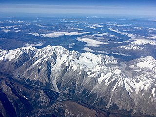
The Mont Blanc massif is a mountain range in the Alps, located mostly in France and Italy, but also straddling Switzerland at its northeastern end. It contains eleven major independent summits, each over 4,000 metres (13,123 ft) in height. It is named after Mont Blanc, the highest point in western Europe and the European Union. Because of its considerable overall altitude, a large proportion of the massif is covered by glaciers, which include the Mer de Glace and the Miage Glacier – the longest glaciers in France and Italy, respectively.

The Ober Gabelhorn is a mountain in the Pennine Alps in Switzerland, located between Zermatt and Zinal.

Mont Blanc de Courmayeur is a point on the south-east ridge of Mont Blanc that forms the peak of the massive south-east face of the mountain. It is connected to the main summit via the Col Major.

Mont Dolent is a mountain in the Mont Blanc massif and lies on the border between Italy, Switzerland and France.

Alexander Burgener was a Swiss mountain guide and the first ascentionist of many mountains and new routes in the western Alps during the silver age of alpinism.
Robert Lock Graham Irving, was an English schoolmaster, climbing writer and mountaineer. As an author, he used the name R. L. G. Irving, while to his friends he was Graham Irving. He is noted for being the person who introduced George Mallory to mountaineering.
Moriz von Kuffner was a Jewish-Austrian industrialist, art collector, mountaineer and philanthropist. From the 1880s to the early 1910s he made a fortune in the brewery business, and became a significant sponsor of Vienna's social and cultural life as well as a mentor of astronomy. Moriz von Kuffner was forced to sell his Austrian assets and to leave Vienna in 1938.

The Cosmiques Hut is a mountain hut in the Mont Blanc massif in the French Alps at an altitude of 3,613 m. It is a large structure capable of accommodating 148 mountaineers. It was constructed in 1990 on a rock promontory situated between the Col du Midi and the base of the Cosmiques Arête which descends southwards from the Aiguille du Midi. It gives access to a number of classic alpine mountaineering routes, and has proved to be extremely popular with mountaineers, so much so that in the summer months prior booking a few days beforehand is essential in order to secure a bed. The Hut is wardened between mid-February and mid-October. In winter the nearby Abri Simond Hut is left unlocked, although this has no cooking facilities, heating or water.
The Quintino Sella Hut is a very remote bivouac hut in the Mont Blanc massif of the Alps in Aosta Valley, Italy. Built in 1885, it is perched on rocks on the south-western flank of the Rocher du Mont Blanc at an altitude of 3,396 m. It is owned by the CAI and can accommodate up to sixteen people with bunk and blankets provided, but no stove or warden.

The Torino Hut is a high mountain refuge in the Alps in northwestern Italy. Located near the border with France, it is about 15 km (10 mi) southwest of Mont Dolent, the tripoint with Switzerland. The refuge is in the Mont Blanc massif above the town of Courmayeur in the Aosta Valley, Italy. It can be most easily accessed from the Italian side by the Skyway Monte Bianco cable car from La Palud in Courmayeur, with a change at the Pavilion du Mont Fréty. It can also be reached from Chamonix via the Aiguille du Midi, either by cable car which crosses the massif, or by a long crossing of the Glacier du Gèant. The refuge lies nearly directly above the 11.6 km (7.2 mi) Mont Blanc Tunnel, which passes deep underground, and connects Courmayeur to Chamonix.
Émile Rey was an alpine mountain guide from Aosta Valley in Italy. Dubbed "the Prince of Guides" in Courmayeur, he was one of the most renowned guides at the end of the 19th century, making many first ascents on some of the highest and most difficult mountains in the Mont Blanc massif of the Alps. He has been described as "one of the greatest guides of his generation."
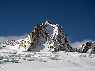
The Tour Ronde is a mountain in the Mont Blanc massif of the Alps, situated on the border between France and Italy. It is a prominent mountain, some 3.5 km north-east of Mont Blanc, but is effectively part of a continuation of the south eastern spur of Mont Maudit which forms a frontier ridge between the two countries. It is easily accessible to mountaineers and provides not only a very good viewpoint from its summit of the Brenva face and the major peaks on the southern side of Mont Blanc, but it also offers a popular introduction to alpine climbing of all grades, including a north face ascent.

The Goûter Hut, is a mountain refuge in the French department of Haute-Savoie. It is located at a height of 3,835 metres (12,582 ft) on the Arete du Goûter in the municipality of Saint-Gervais-les-Bains. It overlooks the Glacier de Bionnassay, and is the highest wardened mountain hut in France.
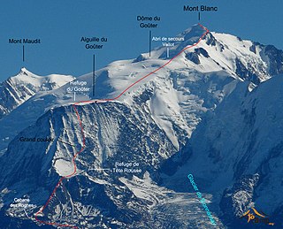
The Goûter Route is one of the two normal mountaineering routes used to reach the summit of Mont Blanc in the Alps, ascending to a height of 4,808 metres (15,774 ft). The route lies on the north side of the mountain, in France. Usually reckoned as the easiest route up Mont Blanc, it is extremely popular with mountaineers, seeing thousands of ascents per year.


