Aiguille Blanche de Peuterey

Last updated
Aiguille Blanche de Peuterey
Blanche de Peuterey.JPG
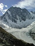
The north face of the Aiguille Blanche de Peuterey with its three summits, seen from the Pointe Helbronner
Highest point
Elevation 4,112 m (13,491 ft)
Prominence 178 m (584 ft)  OOjs UI icon edit-ltr-progressive.svg
Isolation 1 km (0.62 mi)  OOjs UI icon edit-ltr-progressive.svg
Coordinates 45°49′28″N6°52′58″E / 45.82444°N 6.88278°E / 45.82444; 6.88278 Coordinates: 45°49′28″N6°52′58″E / 45.82444°N 6.88278°E / 45.82444; 6.88278
Geography
Alps location map.png
Red triangle with thick white border.svg
Aiguille Blanche de Peuterey
Parent range Graian Alps
Geology
Mountain type Granite
Climbing
First ascent 31 July 1885 by Henry Seymour King with guides Emile Rey, Ambros Supersaxo and Aloys Anthamatten
Easiest route South-east ridge (D+)

The Aiguille Blanche de Peuterey (4,112 m) is a mountain of the Mont Blanc massif in Italy. It is considered the most difficult and serious [1] of the alpine 4000-m mountains to climb.

Contents

There are three tops to the mountain:

The three tops are named after Paul Güssfeldt, Henry Seymour King and Humphrey Owen Jones.

Ascents

The highest point, Pointe Güssfeldt, was first climbed by Henry Seymour King with guides Emile Rey, Ambros Supersaxo and Aloys Anthamatten on 31 July 1885.

In July 1882, Francis Maitland Balfour, a young English professor, lost his life whilst attempting the as-yet-unclimbed summit of the Aiguille Blanche along with his guide Johann Petrus (an uncle of Joseph Knubel). C. D. Cunningham and Emile Rey watched anxiously and silently as the pair set off on the 18th, [2] :231 and it was Rey who was subsequently leader of the search party that brought back their bodies to Courmayeur. [3]

Peuterey ridge

The Aiguilles de Peuterey seen from Val Veny. Aiguille Blanche de Peuterey (extreme left, top), Aiguille Noire de Peuterey (right) AiguillesPeuterey0002.jpg
The Aiguilles de Peuterey seen from Val Veny. Aiguille Blanche de Peuterey (extreme left, top), Aiguille Noire de Peuterey (right)

Together with its neighbour – the Aiguille Noire de Peuterey (3,773 m) – the Aiguille Blanche forms part of the Peuterey ridge that leads, via the summit of the Grand Pilier d'Angle, to the summit of Mont Blanc. James Eccles, with guides Alphonse and Michel Payot, made the first ascent of the upper part of the ridge during their first ascent of Mont Blanc de Courmayeur on 31 July 1877. [1] The main ridge itself was first climbed via a couloir on the Brenva face by Paul Güssfeldt with Emile Rey, Christian Klucker and César Ollier on 15–19 August 1893 (the second ascent was a week later by Klucker and John Percy Farrar). The first ascent of the complete ridge including the Aiguille Noire de Peuterey (the Intégrale) was on 28–31 July 1934 by Adolf Göttner, Ludwig Schmaderer and Ferdinand Krobath.

See also

Related Research Articles

Mont Blanc Highest mountain in the Alps (4,810 m)

Mont Blanc is the highest mountain in the Alps and Western Europe, rising 4,808 m (15,774 ft) above sea level. It is the second-highest and second most prominent mountain in Europe, after Mount Elbrus, and it is the eleventh most prominent mountain summit in the world. The mountain stands between the regions of Aosta Valley, Italy, and Savoie and Haute-Savoie, France. It gives its name to the Mont Blanc massif, which itself forms part of a larger range referred to as the Graian Alps. The location of the summit of Mont Blanc is on the watershed line between the valleys of Ferret and Veny in Italy and the valleys of Montjoie, and Arve in France, on the border between the two countries. Ownership of the summit area has long been a subject of historical dispute between the two countries.

The higher region of the Alps were long left to the exclusive attention of the inhabitants of the adjoining valleys, even when Alpine travellers began to visit these valleys. It is reckoned that about 20 glacier passes were certainly known before 1600, about 25 more before 1700, and yet another 20 before 1800; but though the attempt of P.A. Arnod in 1689 to "re-open" the Col du Ceant may be counted as made by a non-native, historical records do not show any further such activities until the last quarter of the 18th century. Nor did it fare much better with the high peaks, though the two earliest recorded ascents were due to non-natives, that of the Rocciamelone in 1358 having been undertaken in fulfilment of a vow, and that of the Mont Aiguille in 1492 by order of Charles VIII of France, in order to destroy its immense reputation for inaccessibility – in 1555 Conrad Gesner did not climb Pilatus proper, but only the grassy mound of the Gnepfstein, the lowest and the most westerly of the seven summits.

Aiguille de Bionnassay

The Aiguille de Bionnassay is a mountain in the Mont Blanc massif of the Alps in France and Italy. It has been described as "one of the most attractive satellite peaks of Mont Blanc", and is located on its western side. The mountain's south and east ridges form the frontier between the two countries, and its summit is a knife-edge crest of snow and ice. Reaching it via any route provides a "splendid and serious snow and ice climb".

Aiguille du Midi Mountain

The Aiguille du Midi is a 3,842-metre-tall (12,605 ft) mountain in the Mont Blanc massif within the French Alps. It is a popular tourist destination and can be directly accessed by cable car from Chamonix that takes visitors close to Mont Blanc.

Walter Bonatti Italian mountaineer

Walter Bonatti was an Italian mountain climber, explorer and journalist. He was noted for his many climbing achievements, including a solo climb of a new route on the south-west pillar of the Aiguille du Dru in August 1955, the first ascent of Gasherbrum IV in 1958 and in 1965 the first solo climb in winter of the North face of the Matterhorn on the mountain's centenary year of its first ascent. Immediately after his extraordinary solo climb on the Matterhorn Bonatti announced his retirement from professional climbing at the age of 35 and after 17 years of climbing activity. He authored many mountaineering books and spent the remainder of his career travelling off the beaten track as a reporter for the Italian magazine Epoca. He died on 13 September 2011 of pancreatic cancer in Rome aged 81, and was survived by his life partner, the actress Rossana Podestà.

Christian Klucker

Christian Klucker was a Swiss mountain guide who made many first ascents in the Alps, particularly in the Bernina Range, the Bregaglia and the Pennine Alps.

Paul Güssfeldt

Dr Paul Güssfeldt was a German geologist, mountaineer and explorer.

Dent du Géant

The Dent du Géant is a mountain in the Mont Blanc massif in France and Italy.

Mont Blanc de Courmayeur

Mont Blanc de Courmayeur is a point on the south-east ridge of Mont Blanc that forms the peak of the massive south-east face of the mountain. It is connected to the main summit via the Col Major.

Humphrey Owen Jones was a Welsh chemist and mountaineer.

John Percy Farrar

Captain John Percy Farrar DSO FGS, also known as Percy Farrar and as J. P. Farrar, was an English soldier and mountaineer. He was President of the Alpine Club from 1917 to 1919 and a member of the Mount Everest Committee. Farrar's obituary in The Times stated that he 'was known by repute to every one interested in mountaineering in England and on the Continent, and his personal friends at home and abroad were legion'.

The silver age of alpinism is the name given in the United Kingdom to the era in mountaineering that began after Edward Whymper and party's ascent of the Matterhorn in 1865 and ended with W. W. Graham and party's ascent of the Dent du Géant in 1882.

Cosmiques Hut

The Cosmiques Hut is a mountain hut in the Mont Blanc massif in the French Alps at an altitude of 3,613 m. It is a large structure capable of accommodating 148 mountaineers. It was constructed in 1990 on a rock promontory situated between the Col du Midi and the base of the Cosmiques Arête which descends southwards from the Aiguille du Midi. It gives access to a number of classic alpine mountaineering routes, and has proved to be extremely popular with mountaineers, so much so that in the summer months prior booking a few days beforehand is essential in order to secure a bed. The Hut is wardened between mid-February and mid-October. In winter the nearby Abri Simond Hut is left unlocked, although this has no cooking facilities, heating or water.

Torino Hut

The Torino Hut is a high mountain refuge in the Alps in northwestern Italy. Located near the border with France, it is about 15 km (10 mi) southwest of Mont Dolent, the tripoint with Switzerland. The refuge is in the Mont Blanc massif above the town of Courmayeur in the Aosta Valley, Italy. It can be most easily accessed from the Italian side by the Skyway Monte Bianco cable car from La Palud in Courmayeur, with a change at the Pavilion du Mont Fréty. It can also be reached from Chamonix via the Aiguille du Midi, either by cable car which crosses the massif, or by a long crossing of the Glacier du Gèant. The refuge lies nearly directly above the 11.6 km (7.2 mi) Mont Blanc Tunnel, which passes deep underground, and connects Courmayer to Chamonix.

Aiguille Noire de Peuterey

The Aiguille Noire de Peuterey is a mountain of the Mont Blanc massif in Italy, forming part of the Peuterey ridge to the summit of Mont Blanc with its higher neighbour, the Aiguille Blanche de Peuterey.

James Eccles

James Eccles FGS was an English mountaineer and geologist who is noted for making a number of first ascents in the Alps during the silver age of alpinism.

Émile Rey Italian mountain guide and mountaineer (1846-1895)

Émile Rey was an alpine mountain guide from Aosta Valley in Italy. Dubbed "the Prince of Guides" in Courmayeur, he was one of the most renowned guides at the end of the 19th century, making many first ascents on some of the highest and most difficult mountains in the Mont Blanc massif of the Alps. He has been described as "one of the greatest guides of his generation."

Tour Ronde

The Tour Ronde is a mountain in the Mont Blanc massif of the Alps, situated on the border between France and Italy. It is a prominent mountain, some 3.5 km north-east of Mont Blanc, but is effectively part of a continuation of the south eastern spur of Mont Maudit which forms a frontier ridge between the two countries. It is easily accessible to mountaineers and provides not only a very good viewpoint from its summit of the Brenva face and the major peaks on the southern side of Mont Blanc, but it also offers a popular introduction to alpine climbing of all grades, including a north face ascent.

Rocher de la Tournette

The Rocher de la Tournette is a prominent rocky point on the icy summit ridge of Mont Blanc between the Petite Bosse and the summit. The highest point lies at 4,677 metres (15,344 ft) above sea level, and can be most easily reached on an ascent of Mont Blanc via the Goûter Route.

Aiguille de la Brenva

The Aiguille de la Brenva is a remote rocky mountain peak in the Mont Blanc massif of the Alps. It lies wholly within Italy on a ridge descending south-east from the Tour Ronde. It has been described as "a spectacular fin with a fine E face". It stands on a ridge separating the Entrèves glacier from the Brenva glacier, yet is somewhat overshadowed by its larger neighbours, such as the Aiguille Blanche and the Aiguille Noire de Peuterey. Nevertheless, it is a distinctive peak, offering a number of very challenging climbs, especially on its east face which consists of vertical granite flakes and cracks. On its northern side stands a distinctive, slender rock pinnacle about 60 metres high, known as the Père Eternel.

References

  1. 1 2 Dumler, Helmut and Burkhardt, Willi P., The High Mountains of the Alps, London: Diadem, 1994, p. 193
  2. Gos, Charles (1937). "A Winter's Day at Courmayeur" (PDF). The Alpine Journal. 49–50: 232. Retrieved 12 November 2015.
  3. Cunningham, C.D.; Abney, Cptn W. de W. (1888). "The Pioneers of the Alps" (PDF). The Alpine Journal. Retrieved 16 November 2015.