
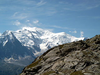
Mont Blanc is the highest mountain in the Alps and Western Europe, rising 4,808 m (15,774 ft) above sea level. It is the second-highest and second most prominent mountain in Europe, after Mount Elbrus, and it is the eleventh most prominent mountain summit in the world. The mountain stands between the regions of Aosta Valley, Italy, and Savoie and Haute-Savoie, France. It gives its name to the Mont Blanc massif, which itself forms part of a larger range referred to as the Graian Alps. The location of the summit of Mont Blanc is on the watershed line between the valleys of Ferret and Veny in Italy and the valleys of Montjoie, and Arve in France, on the border between the two countries. Ownership of the summit area has long been a subject of historical dispute between the two countries.

The Graian Alps are a mountain range in the western part of the Alps.

The Mont Blanc massif is a mountain range in the Alps, located mostly in France and Italy, but also straddling Switzerland at its northeastern end. It contains eleven major independent summits, each over 4,000 metres (13,123 ft) in height. It is named after Mont Blanc, the highest point in western Europe and the European Union. Because of its considerable overall altitude, a large proportion of the massif is covered by glaciers, which include the Mer de Glace and the Miage Glacier – the longest glaciers in France and Italy, respectively.

Mont Blanc de Courmayeur is a point on the south-east ridge of Mont Blanc that forms the peak of the massive south-east face of the mountain. It is connected to the main summit via the Col Major.

Mont Dolent is a mountain in the Mont Blanc massif and lies on the border between Italy, Switzerland and France.
The Dôme du Goûter is a mountain in the Mont Blanc massif. It is a shoulder of Mont Blanc, whose summit lies two kilometres to the south-east. The Dôme is traversed on ascents of Mont Blanc via the Bosses route.

Le Portalet is a mountain of the Mont Blanc massif, located west of Praz de Fort in the canton of Valais. It lies on the range between the glaciers of Trient and Saleina. It has two important subsidiary summits: Grand Clocher du Portalet and Petit Clocher du Portalet. The latter forms a needle and is particularly hard to climb.

The Aiguilles Dorées are a multi-summited mountain of the Mont Blanc massif, overlooking the Plateau du Trient in the canton of Valais. They lie east of the Petite Fourche, on the range between the glaciers of Trient and Saleina.
The Pointe des Plines is a minor peak on the east edge of the Mont Blanc massif, close to the Aiguille Dorees, and overlooking the Saleina Glacier in the canton of Valais.

The Grande Lui is a mountain of the Mont Blanc massif, located west of La Fouly in the canton of Valais. It lies east of the Aiguille de l'A Neuve, on the range between the glaciers of Saleina and L'A Neuve.
The Petit Darray is a mountain of the Mont Blanc Massif, located north of La Fouly in the canton of Valais. It lies west of the Grand Darray, on the range south of the Saleina Glacier.
The Grande Pointe des Planereuses is a mountain of the Mont Blanc massif, located west of Praz de Fort in the canton of Valais, Switzerland. It lies on the range south of the Saleina Glacier.

Val Ferret is the name of the two separate valleys, departing from the Col Ferret on the border between Italy and Switzerland, on the southern and eastern sides of the Mont Blanc Massif. The Swiss valley drains northeastwards towards Orsières and on into the Rhône basin; whereas the Italian valley drains southwestwards towards Courmayeur and on into the Po basin.

The Aiguille du Chardonnet is a mountain in the Mont Blanc massif in Haute-Savoie, France. It lies between the Glacier du Tour and the Argentière Glacier. The border with Switzerland runs just east of the summit. The East or Forbes Arete provides a popular and classic mountaineering route to the summit.

Picco Luigi Amedeo is a mountain in the Mont Blanc massif in the Val d'Aosta, Italy. It lies on the Brouillard ridge to the summit of Mont Blanc.

The Aiguilles d'Entrèves is a mountain peak in the Mont Blanc massif of the Alps. It is situated at the head of the Glacier du Géant, and its rocky summit ridge forms part of the frontier between France and Italy. It lies east of the Tour Ronde, between the Col d'Entrèves and the Col Occidental de Toule. It has a steep, sound face of red granite and can be readily accessed from the Torino Hut/Pointe Helbronner.
The Grand Flambeau is a mountain peak in the Mont Blanc massif of the Alps. It is situated at the head of the Géant Glacier, approximately 0.5km east of the Aiguille de Toule, between the Col Orientale de Toule and the Col de Saussure.

The Aiguille de Toule is a mountain peak in the Mont Blanc massif of the Alps. Its summit is one of a number which form part of the mountainous frontier ridge between France and Italy which descends eastwards from Mont Blanc and continues towards the Grandes Jorasses and Mont Dolent.

The Aiguille de la Brenva is a remote rocky mountain peak in the Mont Blanc massif of the Alps. It lies wholly within Italy on a ridge descending south-east from the Tour Ronde. It has been described as "a spectacular fin with a fine E face". It stands on a ridge separating the Entrèves glacier from the Brenva glacier, yet is somewhat overshadowed by its larger neighbours, such as the Aiguille Blanche and the Aiguille Noire de Peuterey. Nevertheless, it is a distinctive peak, offering a number of very challenging climbs, especially on its east face which consists of vertical granite flakes and cracks. On its northern side stands a distinctive, slender rock pinnacle about 60 metres high, known as the Père Eternel.


