Mont Blanc du Tacul

Last updated
Mont Blanc du Tacul

Mont Blanc du Tacul depuis l'Aiguille du Midi.jpg

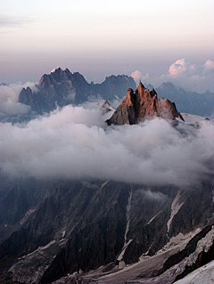
The northern side of Mont Blanc du Tacul seen from the Aiguille du Midi
Highest point
Elevation 4,248 m (13,937 ft)
Prominence 219 mCol Maudit [1]
Isolation 1.38 km Mont Maudit [1]
Coordinates 45°51′23″N06°53′16″E / 45.85639°N 6.88778°E / 45.85639; 6.88778 Coordinates: 45°51′23″N06°53′16″E / 45.85639°N 6.88778°E / 45.85639; 6.88778
Geography
France relief location map.jpg
Red triangle with thick white border.svg
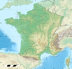
Mont Blanc du Tacul
France
Location Haute-Savoie, France
Parent range Graian Alps
Geology
Mountain type Granite
Climbing
First ascent Charles Hudson, Edward John Stevenson, Christopher and James Grenville Smith, E. S. Kennedy, Charles Ainslie and G. C. Joad on 8 August 1855
Easiest route North-west face (PD)

Mont Blanc du Tacul (4,248 m) is a mountain in the Mont Blanc massif of the French Alps situated midway between the Aiguille du Midi and Mont Blanc.

Mountain A large landform that rises fairly steeply above the surrounding land over a limited area

A mountain is a large landform that rises above the surrounding land in a limited area, usually in the form of a peak. A mountain is generally steeper than a hill. Mountains are formed through tectonic forces or volcanism. These forces can locally raise the surface of the earth. Mountains erode slowly through the action of rivers, weather conditions, and glaciers. A few mountains are isolated summits, but most occur in huge mountain ranges.

Mont Blanc massif Mountain range in the Alps

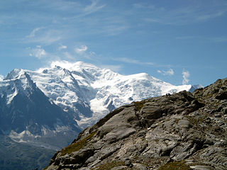
The Mont Blanc massif is a mountain range in the Alps, located mostly in France and Italy, but also straddling Switzerland at its northeastern end. It contains eleven major independent summits, each over 4,000 metres (13,123 ft) in height. It is named after Mont Blanc, the highest point in western Europe and the European Union. Because of its considerable overall altitude, a large proportion of the massif is covered by glaciers, which include the Mer de Glace and the Miage Glacier – the longest glaciers in France and Italy, respectively.

French Alps part of the Alps mountain range in France

The French Alps are the portions of the Alps mountain range that stand within France, located in the Auvergne-Rhône-Alpes and Provence-Alpes-Côte d'Azur regions. While some of the ranges of the French Alps are entirely in France, others, such as the Mont Blanc massif, are shared with Switzerland and Italy.

The official first ascent of Mont Blanc du Tacul was by a guideless party comprising Charles Hudson, Edward John Stevenson, Christopher and James Grenville Smith, E. S. Kennedy, Charles Ainslie and G. C. Joad on 8 August 1855. However, Courmayeur guides may have already ascended the peak during their attempts in 1854 and 1855 to force a way up Mont Blanc from the Italian side. [2]

First ascent first successful, documented attainment of the top of a mountain, or specific route

In mountaineering, a first ascent is the first successful, documented attainment of the top of a mountain, or the first to follow a particular climbing route. First mountain ascents are notable because they entail genuine exploration, with greater risks, challenges, and recognition than climbing a route pioneered by others. The person who performs the first ascent is called the first ascensionist.

Charles Hudson (climber) Anglican chaplain, British mountain climber

Charles Hudson was an Anglican chaplain and mountain climber from Skillington, Lincolnshire, England.

Edward Shirley Kennedy (1817–1898) was an English mountaineer and author, and a founding member of the Alpine Club.

Related Research Articles

The higher region of the Alps were long left to the exclusive attention of the inhabitants of the adjoining valleys, even when Alpine travellers began to visit these valleys. It is reckoned that about 20 glacier passes were certainly known before 1600, about 25 more before 1700, and yet another 20 before 1800; but though the attempt of P.A. Arnod in 1689 to "re-open" the Col du Ceant may be counted as made by a non-native, historical records do not show any further such activities until the last quarter of the 18th century. Nor did it fare much better with the high peaks, though the two earliest recorded ascents were due to non-natives, that of the Rocciamelone in 1358 having been undertaken in fulfilment of a vow, and that of the Mont Aiguille in 1492 by order of Charles VIII of France, in order to destroy its immense reputation for inaccessibility – in 1555 Conrad Gesner did not climb Pilatus proper, but only the grassy mound of the Gnepfstein, the lowest and the most westerly of the seven summits.

Mer de Glace glacier

The Mer de Glace is a valley glacier located on the northern slopes of the Mont Blanc massif, in the French Alps. It is 7.5 km long and 200 metres (660 ft) deep but, when all its tributary glaciers are taken into account, it can be regarded as the longest and largest glacier in France, and the second longest in the Alps after the Aletsch Glacier.

I can no otherwise convey to you an image of this body of ice, broken into irregular ridges and deep chasms than by comparing it to waves instantaneously frozen in the midst of a violent storm.

Aiguille du Midi mountain

The Aiguille du Midi is a mountain in the Mont Blanc massif within the French Alps. It is a popular tourist destination and can be directly accessed by cable car from Chamonix that takes visitors close to Mont Blanc.

Golden age of alpinism

The golden age of alpinism was the decade in mountaineering between Alfred Wills's ascent of the Wetterhorn in 1854 and Edward Whymper's ascent of the Matterhorn in 1865, during which many major peaks in the Alps saw their first ascents.

Dôme du Goûter mountain in the Mont Blanc massif in the Alps

The Dôme du Goûter is a mountain in the Mont Blanc massif. It is a shoulder of Mont Blanc, whose summit lies two kilometres to the south-east. The Dôme is traversed on ascents of Mont Blanc via the Bosses route.

Cosmiques Hut building

The Cosmiques Hut is a mountain hut in the Mont Blanc massif in the French Alps at an altitude of 3,613 m. It is a large structure capable of accommodating 148 mountaineers. It was constructed in 1990 on a rock promontory situated between the Col du Midi and the base of the Cosmiques Arête which descends southwards from the Aiguille du Midi. It gives access to a number of classic alpine mountaineering routes, and has proved to be extremely popular with mountaineers, so much so that in the summer months prior booking a few days beforehand is essential in order to secure a bed. The Hut is wardened between mid-February and mid-October. In winter the nearby Abri Simond Hut is left unlocked, although this has no cooking facilities, heating or water.

Torino Hut italian mountain hut

The Torino Hut is a high mountain refuge in the Alps in northwestern Italy. Located near the border with France, it is about 15 km (10 mi) southwest of Mont Dolent, the tripoint with Switzerland. The refuge is in the Mont Blanc massif above the town of Courmayeur in the Aosta Valley, Italy. It can be most easily accessed from the Italian side by the Skyway Monte Bianco cable car from La Palud in Courmayeur, with a change at the Pavilion du Mont Fréty. It can also be reached from Chamonix via the Aiguille du Midi, either by cable car which crosses the massif, or by a long crossing of the Glacier du Gèant. The refuge lies nearly directly above the 11.6 km (7.2 mi) Mont Blanc Tunnel, which passes deep underground, and connects Courmayer to Chamonix.

Aiguilles du Diable mountain in the Mont Blanc massif in the Alps

The Aiguilles du Diable are a group of five rock needles, all over 4,000 metres high, on the southeast arête (also called the Teufelsgrat or Devil's Ridge of the Mont Blanc du Tacul. The pinnacles lies within the French part of the Mont Blanc Massif in the departement of Haute-Savoie. The highest needle is L’Isolée, followed by Pointe Carmen, Pointe Médiane, Pointe Chaubert und Corne du Diable.

Patrick Gabarrou a.k.a. "Le Gab", is a French mountaineer and mountain guide who is credited with more than 300 first ascents, most of them in the Mont Blanc massif.

Jean-Marc Boivin French multiple extreme sports participant

Jean-Marc Boivin was a French mountaineer, extreme skier, hang glider and paraglider pilot, speleologist, BASE jumper, award-winning film maker, and author. The holder of several altitude records for hang gliding and paragliding, the creator of numerous first ascents and first ski descents in the Alps, a member of the team that broke the record for a sub-glacial dive and the first person to paraglide from the summit of Mount Everest, Boivin was a pioneer of extreme sports. He died from injuries incurred after BASE jumping off Angel Falls in Venezuela, the highest waterfall in the world.

Pointe Lachenal

Pointe Lachenal is a mountain in the Mont Blanc massif in the French Alps.

Armand Charlet French mountaineer and guide

Armand Charlet was a French mountaineer and mountain guide.

Grand Flambeau mountain in Italy

The Grand Flambeau is a mountain peak in the Mont Blanc massif of the Alps. It is situated at the head of the Géant Glacier, approximately 0.5km east of the Aiguille de Toule, between the Col Orientale de Toule and the Col de Saussure.

Aiguille de Toule mountain in Italy

The Aiguille de Toule is a mountain peak in the Mont Blanc massif of the Alps. Its summit is one of a number which form part of the mountainous frontier ridge between France and Italy which descends eastwards from Mont Blanc and continues towards the Grandes Jorasses and Mont Dolent.

References

  1. 1 2 Mont Blanc du Tacul, France at peakbagger.com, retrieved 20 Feb 2016
  2. For this claim see Helmut Dumler and Willi P. Burkhardt, The High Mountains of the Alps, London: Diadem, 1994, p. 219
Mont Blanc du Tacul (far left), Mont Maudit (left) and Mont Blanc (centre) Mont-Blanc depuis Brevent 2006.jpg
Mont Blanc du Tacul (far left), Mont Maudit (left) and Mont Blanc (centre)
Aerial photo of Mont Blanc and other summits Mont Blanc photo aerienne.jpg
Aerial photo of Mont Blanc and other summits