Grande Pointe des Planereuses

Last updated
Grande Pointe des Planereuses
Switzerland relief location map.jpg
Red triangle with thick white border.svg
Grande Pointe des Planereuses
Location in Switzerland
Highest point
Elevation 3,151 m (10,338 ft)
Prominence 121 m (397 ft) [1]
Coordinates 45°58′05.7″N07°04′20.2″E / 45.968250°N 7.072278°E / 45.968250; 7.072278 Coordinates: 45°58′05.7″N07°04′20.2″E / 45.968250°N 7.072278°E / 45.968250; 7.072278
Geography
Location Valais, Switzerland
Parent range Mont Blanc Massif

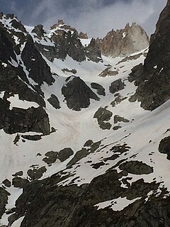
The Grande Pointe des Planereuses is a mountain of the Mont Blanc massif, located west of Praz de Fort in the canton of Valais, Switzerland. It lies on the range south of the Saleina Glacier.

Mountain A large landform that rises fairly steeply above the surrounding land over a limited area

A mountain is a large landform that rises above the surrounding land in a limited area, usually in the form of a peak. A mountain is generally steeper than a hill. Mountains are formed through tectonic forces or volcanism. These forces can locally raise the surface of the earth. Mountains erode slowly through the action of rivers, weather conditions, and glaciers. A few mountains are isolated summits, but most occur in huge mountain ranges.

Mont Blanc massif Mountain range in the Alps

The Mont Blanc massif is a mountain range in the Alps, located mostly in France and Italy, but also straddling Switzerland at its northeastern end. It contains eleven major independent summits, each over 4,000 metres (13,123 ft) in height. It is named after Mont Blanc, the highest point in western Europe and the European Union. Because of its considerable overall altitude, a large proportion of the massif is covered by glaciers, which include the Mer de Glace and the Miage Glacier – the longest glaciers in France and Italy, respectively.

Switzerland federal republic in Central Europe

Switzerland, officially the Swiss Confederation, is a country situated in western, central and southern Europe. It consists of 26 cantons, and the city of Bern is the seat of the federal authorities. The sovereign state is a federal republic bordered by Italy to the south, France to the west, Germany to the north, and Austria and Liechtenstein to the east. Switzerland is a landlocked country geographically divided between the Alps, the Swiss Plateau and the Jura, spanning a total area of 41,285 km2 (15,940 sq mi). While the Alps occupy the greater part of the territory, the Swiss population of approximately 8.5 million people is concentrated mostly on the plateau, where the largest cities are to be found: among them are the two global cities and economic centres Zürich and Geneva.

Related Research Articles

Pointe-à-Pitre Subprefecture and commune in Guadeloupe, France

Pointe-à-Pitre is the largest city of Guadeloupe, an overseas région and département of France located in the Lesser Antilles, of which it is a sous-préfecture, being the seat of the Arrondissement of Pointe-à-Pitre.

Pointe-à-Pitre International Airport airport

Pointe-à-Pitre International Airport or Pointe-à-Pitre Le Raizet Airport is an international airport serving Pointe-à-Pitre on the island of Grande-Terre in Guadeloupe, France.

Massif des Écrins mountain range

The mountains of the Massif des Écrins form the core of the Écrins National Park in France.

Grande-Terre island in Guadeloupe, France

Grande-Terre Island is the name of the eastern-half of Guadeloupe proper, in the Lesser Antilles. It is separated from the other half of Guadeloupe island, Basse-Terre, by a narrow sea channel called Rivière Salée. Pointe de la Grande Vigie, in Grande-Terre, is the northernmost point of Guadeloupe island. To the east lies La Désirade, to the south lies Marie Galante

Grandes Jorasses mountain in the Mont Blanc massif in the Alps

The Grandes Jorasses is a mountain in the Mont Blanc massif, on the boundary between Haute-Savoie in France and Aosta Valley in Italy.

Quebec Route 199 highway in Quebec

Route 199 is an 85 km (53 mi) north–south highway located on the Magdalen Islands, in the Gulf of Saint Lawrence. Stretching from Les Îles-de-la-Madeleine's communities of L'Île-du-Havre-Aubert to Grande-Entrée, the route is the main artery of the archipelago and is the only Quebec numbered highway that is detached from the rest of the network.

La Possession Commune in Réunion, France

La Possession is a commune in the French overseas department of Réunion. It is located on the northwest side of the island of Réunion, between the capital of Saint-Denis and the commune of Le Port.

The Rural Municipality of Richot is a rural municipality bordering the south side of Winnipeg in Manitoba, Canada. It is part of the Winnipeg Capital Region. The separately administered town of Niverville lies adjacent to its southeastern part, between it and the Rural Municipality of Hanover. The Rural Municipalty of Macdonald is to the west, and the Rural Municipality of Taché to the east.

Port-Louis, Guadeloupe Commune in Guadeloupe, France

Port-Louis is a commune in the department of Guadeloupe, on the northwest of Grande-Terre.

Saint-François, Guadeloupe Commune in Guadeloupe, France

Saint-François is a commune of the Guadeloupe department, in the south-east point of the main island, Grande-Terre.

Vanoise massif mountains in France

The Vanoise massif is a mountain range of the Graian Alps, located in the Western Alps. After the Mont Blanc Massif and the Massif des Écrins it is the third highest massif in France, reaching a height of 3,885m at the summit of Grande Casse. It lies between Tarentaise Valley to the north and the Maurienne valley in the south. The range is the site of France's first National Park in 1963, the Vanoise National Park. The ski resorts of Tignes and Val-d'Isère and the 2,770m high Col de l'Iseran are located in the eastern part of the range.

Michel Croz French mountain climber and guide

Michel Auguste Croz was a French mountain guide and the first ascentionist of many mountains in the western Alps during the golden age of alpinism. He is chiefly remembered for his death on the first ascent of the Matterhorn and for his climbing partnership with Edward Whymper.

Pointe des Berons mountain in Switzerland

The Pointe des Berons is a mountain of the Mont Blanc Massif, located on the border between Switzerland and France. It lies approximately halfway between the Col de Balme and the Aiguille du Tour. The east (Swiss) side is covered by the Glacier des Berons.

Pointe des Plines mountain in Switzerland

The Pointe des Plines is a minor peak on the east edge of the Mont Blanc massif, close to the Aiguille Dorees, and overlooking the Saleina Glacier in the canton of Valais.

Pointe des Savolaires mountain in Switzerland

The Pointe des Savolaires is a mountain of the western Bernese Alps, located east of Bex in the canton of Vaud. It lies on the chain north of the Dent de Morcles.

Index of Guadeloupe-related articles Wikimedia list article

Articles related to the French overseas department of Guadeloupe include:

Grande Ruine mountain in France

La Grande Ruine is a mountain in Hautes-Alpes, France. It belongs to the Massif des Écrins in the Dauphiné Alps and is located in the heart of the wilderness of the Écrins National Park roughly halfway between its illustrious neighbours Barre des Écrins and Meije. The mountain has two different summits, the Pointe Brevoort at 3,765 m to the south and Pic Maître at 3,726 m to the north.

The Bornes Massif is a mountainous massif in the north French Prealps in the département of Haute-Savoie. It has 20 peaks higher than 2000 m and is a popular destination for winter sports. The Massif is the source of the celebrated cheese Reblochon.

Grande Aiguille Rousse mountain in France

The Grande Aiguille Rousse is a mountain peak of the Graian Alps in Savoie, France, situated between the Maurienne and Tarentaise valleys near the Italian border. Reaching an altitude of 3,482 meters, it exceeds its junior to the west, the Petite Aiguille Rousse, by just 50 m (160 ft). Not far from Levanna, the Grande Aiguille Rousse overlooks Serrù Lake and the Gran Paradiso National Park in Italy.

References

  1. Retrieved from the Swisstopo topographic maps. The key col is the Col des Planereuses (3,030 m).