
Mont Blanc is the highest mountain in the Alps and Western Europe, and the highest mountain in Europe outside the Caucasus Mountains, rising 4,805.59 m (15,766 ft) above sea level, located on the Franco-Italian border. It is the second-most prominent mountain in Europe, after Mount Elbrus, and the 11th most prominent mountain in the world.

The Haute Route is the name given to a route undertaken on foot or by ski touring between the Mont Blanc in Chamonix, France, and the Matterhorn, in Zermatt, Switzerland.
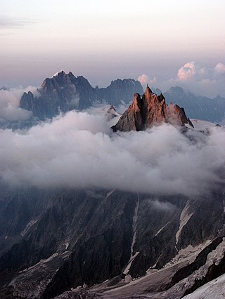
The Aiguille du Midi is a 3,842-metre-tall (12,605 ft) mountain in the Mont Blanc massif within the French Alps. It is a popular tourist destination and can be directly accessed by cable car from Chamonix that takes visitors close to Mont Blanc.
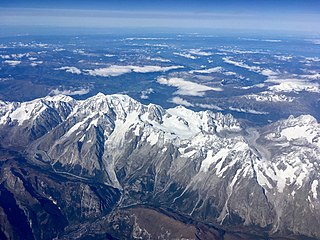
The Mont Blanc massif is a mountain range in the Alps, located mostly in France and Italy, but also straddling Switzerland at its northeastern end. It contains eleven major independent summits, each over 4,000 metres (13,123 ft) in height. It is named after Mont Blanc, the highest point in western Europe and the European Union. Because of its considerable overall altitude, a large proportion of the massif is covered by glaciers, which include the Mer de Glace and the Miage Glacier – the longest glaciers in France and Italy, respectively.

The Bossons Glacier is one of the larger glaciers of the Mont Blanc massif of the Alps, found in the Chamonix valley of Haute-Savoie département, south-eastern France. It is fed from icefields lying on the northern side of Mont Blanc, and descends down close to the Aiguille du Midi and ends on the southern side of the Arve valley, close to the town of Chamonix. It has the largest altitudinal drop of all the alpine glaciers in Europe, and formerly extended much further down the valley than it does today. It is now approximately 7.5 km long, with a surface area of approximately 10 km2.

Mont Dolent is a mountain in the Mont Blanc massif and lies on the border between Italy, Switzerland and France.

The Argentière Hut is a refuge in the Mont Blanc massif in the Alps. Built in 1974 by the Club Alpin Français, it is located above the north bank of the Argentière Glacier in France at an altitude of 2,691 meters above sea level.

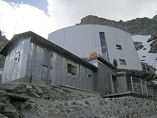
The Cosmiques Hut is a mountain hut in the Mont Blanc massif in the French Alps at an altitude of 3,613 m. It is a large structure capable of accommodating 148 mountaineers. It was constructed in 1990 on a rock promontory situated between the Col du Midi and the base of the Cosmiques Arête which descends southwards from the Aiguille du Midi. It gives access to a number of classic alpine mountaineering routes, and has proved to be extremely popular with mountaineers, so much so that in the summer months prior booking a few days beforehand is essential in order to secure a bed. The Hut is wardened between mid-February and mid-October. In winter the nearby Abri Simond Hut is left unlocked, although this has no cooking facilities, heating or water.

The Durier Hut is a mountain hut in the Mont Blanc massif of the Alps. It is located in Haute-Savoie department of France on the French/Italian border at an altitude of 3358 m.

The Leschaux Hut is a refuge in the Mont Blanc massif in the Alps. It is located at 2,431 m on the north side of the Glacier de Leschaux – a tributary of the Mer de Glace. It is owned by the CAF and can accommodate up to 19 people. The hut is used as a base by mountaineers climbing peaks such as Grandes Jorasses, Petites Jorasses and Mont Mallet. It is accessed by going up the Mer de Glace from Montenvers, and then up the Glacier de Leschaux. The first refuge was built in 1929. It was enlarged to 30 seats in 1934, but destroyed by an avalanche in 1954. A new hut was built in 1968 and was enlarged in 2003.
The Quintino Sella Hut is a very remote bivouac hut in the Mont Blanc massif of the Alps in Aosta Valley, Italy. Built in 1885, it is perched on rocks on the south-western flank of the Rocher du Mont Blanc at an altitude of 3,396 m. It is owned by the CAI and can accommodate up to sixteen people with bunk and blankets provided, but no stove or warden.

The Torino Hut is a high mountain refuge in the Alps in northwestern Italy. Located near the border with France, it is about 15 km (10 mi) southwest of Mont Dolent, the tripoint with Switzerland. The refuge is in the Mont Blanc massif above the town of Courmayeur in the Aosta Valley, Italy. It can be most easily accessed from the Italian side by the Skyway Monte Bianco cable car from La Palud in Courmayeur, with a change at the Pavilion du Mont Fréty. It can also be reached from Chamonix via the Aiguille du Midi, either by cable car which crosses the massif, or by a long crossing of the Glacier du Gèant. The refuge lies nearly directly above the 11.6 km (7.2 mi) Mont Blanc Tunnel, which passes deep underground, and connects Courmayeur to Chamonix.

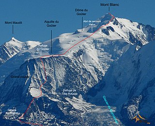
The Tête Rousse Hut is a mountain hut in the Mont Blanc massif in the French Alps. It is located beside the Tête Rousse Glacier at an elevation of 3,167 m. Owned by the Club Alpin Francais (CAF), it is normally reached after an approximately two hour climb from Nid d'Aigle, the highest stop on the Mont Blanc Tramway. It is commonly used by mountaineers attempting to climb the 'normal route' on the French side to the summit of Mont Blanc. Staying here, rather than continuing to the higher Goûter Hut adds an extra 2–3 hours to the ascent of Mont Blanc, but is less cramped than the latter and also avoids having to climb the dangerous 'Grand Couloir' later in the day when the risk of injury from stonefall is at its greatest.

The Vallot Hut is a refuge in the Mont Blanc massif on the upper slopes of Mont Blanc in the Alps. It is located below the Bosses Ridge between the Dome du Gouter and Mont Blanc summit, at an altitude of 4,362 metres. Intended only as an emergency shelter, and not as a base for ascending Mont Blanc, this unheated duralumin box was designed to accommodate up to 12 people, but often contains considerably more.
The Tête Rousse Glacier is a small but significant glacier located in the Mont Blanc massif within the French Alps whose collapse in 1892 killed 200 people in the town of Saint-Gervais-les-Bains.
The Gonella Hut, sometimes called in Italian Rifugio del Dôme or in French Refuge du Dôme, is a high elevation mountain hut in the Aosta Valley in the Mont Blanc massif area of the Alps. It lies at an elevation of 3071 metres, above Val Veny near Courmayeur in Italy. The refuge is located on the Italian normal route to Mont Blanc.
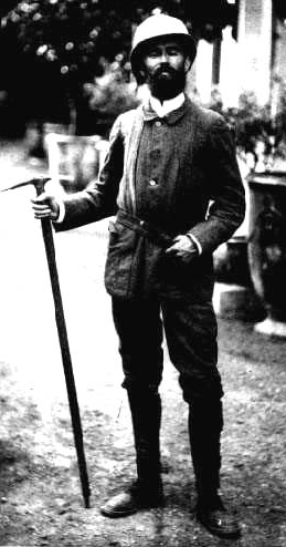
Émile Rey was an alpine mountain guide from Aosta Valley in Italy. Dubbed "the Prince of Guides" in Courmayeur, he was one of the most renowned guides at the end of the 19th century, making many first ascents on some of the highest and most difficult mountains in the Mont Blanc massif of the Alps. He has been described as "one of the greatest guides of his generation."

The Goûter Hut, is a mountain refuge in the French department of Haute-Savoie. It is located at a height of 3,835 metres (12,582 ft) on the Arete du Goûter in the municipality of Saint-Gervais-les-Bains. It overlooks the Glacier de Bionnassay, and is the highest wardened mountain hut in France.
The Goûter Route is one of the two normal mountaineering routes used to reach the summit of Mont Blanc in the Alps, ascending to a height of 4,808 metres (15,774 ft). The route lies on the north side of the mountain, in France. Usually reckoned as the easiest route up Mont Blanc, it is extremely popular with mountaineers, seeing thousands of ascents per year.
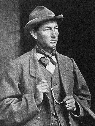
Joseph Vallot was a French scientist, astronomer, botanist, geographer, cartographer and alpinist and "one of the founding fathers of scientific research on Mont Blanc". He is known mainly for his fascination with Mont Blanc and his work in funding and constructing a high-altitude observatory below its summit, and for the many years of study and research work that he and his wife conducted both there, and at their base in Chamonix. The observatory and adjacent refuge that he constructed for use by mountain guides and their clients attempting the Mont Blanc summit both still bear his name today, despite being rebuilt in modern times.


