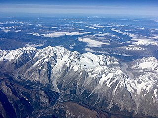
Mont Blanc is the highest mountain in the Alps and Western Europe, and the highest mountain in Europe outside the Caucasus mountains, rising 4,807.81 m (15,774 ft) above sea level, located on the French-Italian border. It is the second-most prominent mountain in Europe, after Mount Elbrus, and it is the eleventh most prominent mountain summit in the world.

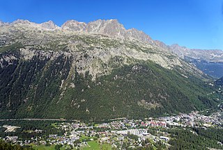
Chamonix-Mont-Blanc, more commonly known as Chamonix, is a commune in the Haute-Savoie department in the Auvergne-Rhône-Alpes region of southeastern France. It was the site of the first Winter Olympics in 1924. In 2019, it had a population of 8,640.
Argentière is a picturesque skiing, alpine walking and mountaineering village in the French Alps, part of the commune of Chamonix-Mont-Blanc, at an altitude of 1,252 m (4,108 ft).

The Aiguille de Bionnassay is a mountain in the Mont Blanc massif of the Alps in France and Italy. It has been described as "one of the most attractive satellite peaks of Mont Blanc", and is located on its western side. The mountain's south and east ridges form the frontier between the two countries, and its summit is a knife-edge crest of snow and ice. Reaching it via any route provides a "splendid and serious snow and ice climb".
The Aiguille du Midi is a 3,842-metre-tall (12,605 ft) mountain in the Mont Blanc massif within the French Alps. It is a popular tourist destination and can be directly accessed by cable car from Chamonix that takes visitors close to Mont Blanc.

The Montenvers Railway or Chemin de fer du Montenvers is a rack railway line in the Haute-Savoie department of France. The line runs from a connection with the SNCF, in Chamonix, to the Hotel de Montenvers station, at the Mer de Glace, at an altitude of 1,913 m (6,276 ft).
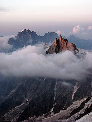
The Mont Blanc massif is a mountain range in the Alps, located mostly in France and Italy, but also straddling Switzerland at its northeastern end. It contains eleven major independent summits, each over 4,000 metres (13,123 ft) in height. It is named after Mont Blanc, the highest point in western Europe and the European Union. Because of its considerable overall altitude, a large proportion of the massif is covered by glaciers, which include the Mer de Glace and the Miage Glacier – the longest glaciers in France and Italy, respectively.

The Saint-Gervais–Vallorcine railway, also known as the Saint-Gervais–Vallorcine Line, is a single-track 36.5 km (22.7 mi) long metre gauge railway in France connecting the SNCF's Saint-Gervais-les-Bains-Le Fayet station with Vallorcine station and the border with Switzerland through Chamonix. Opened in stages between 1901 and 1908 by the Chemins de fer de Paris à Lyon et à la Méditerranée (PLM), it is part of the main SNCF network as far as Vallorcine. To Le Châtelard is run by the Swiss company Transports de Martigny et Régions (TMR), which also operates the Martigny–Châtelard Railway.

Saint-Gervais-les-Bains is a commune in the Haute-Savoie department in the Auvergne-Rhône-Alpes region, southeastern France. The village is best known for tourism and has been a popular holiday destination since the early 1900s. It has 445 km (277 mi) of pistes, the third largest domain exclusively in France, and is one of the least busy ski areas of its size. In 1892, two hundred people were killed when a water pocket in a glacier above the town suddenly burst open and caused flooding.
Pointe Helbronner is a mountain in the Mont Blanc massif in the Graian Alps on the watershed between France and Italy.

The Torino Hut is a high mountain refuge in the Alps in northwestern Italy. Located near the border with France, it is about 15 km (10 mi) southwest of Mont Dolent, the tripoint with Switzerland. The refuge is in the Mont Blanc massif above the town of Courmayeur in the Aosta Valley, Italy. It can be most easily accessed from the Italian side by the Skyway Monte Bianco cable car from La Palud in Courmayeur, with a change at the Pavilion du Mont Fréty. It can also be reached from Chamonix via the Aiguille du Midi, either by cable car which crosses the massif, or by a long crossing of the Glacier du Gèant. The refuge lies nearly directly above the 11.6 km (7.2 mi) Mont Blanc Tunnel, which passes deep underground, and connects Courmayeur to Chamonix.

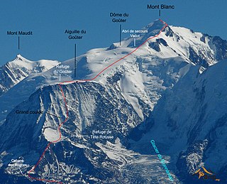
The Tête Rousse Hut is a mountain hut in the Mont Blanc massif in the French Alps. It is located beside the Tête Rousse Glacier at an elevation of 3,167 m. Owned by the Club Alpin Francais (CAF), it is normally reached after an approximately two hour climb from Nid d'Aigle, the highest stop on the Mont Blanc Tramway. It is commonly used by mountaineers attempting to climb the 'normal route' on the French side to the summit of Mont Blanc. Staying here, rather than continuing to the higher Goûter Hut adds an extra 2–3 hours to the ascent of Mont Blanc, but is less cramped than the latter and also avoids having to climb the dangerous 'Grand Couloir' later in the day when the risk of injury from stonefall is at its greatest.
The Tête Rousse Glacier is a small but significant glacier located in the Mont Blanc massif within the French Alps whose collapse in 1892 killed 200 people in the town of Saint-Gervais-les-Bains.

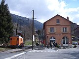
Saint-Gervais-les-Bains-Le Fayet station is a railway station serving the town Saint-Gervais-les-Bains, Haute-Savoie department, southeastern France. It is the southeastern terminus of the standard gauge La Roche-sur-Foron–Saint-Gervais-les-Bains-Le Fayet line from La Roche-sur-Foron, the southwestern terminus of the 1,000 mm gauge Saint-Gervais–Vallorcine line from the Swiss border, and the western terminus of the Mont Blanc Tramway. It is the southeastern terminus of the L3 line of the Léman Express, a suburban rail network for the Grand Genève, which began operation in 2019.
The Gonella Hut is a high elevation mountain hut in the Aosta Valley in the Mont Blanc massif area of the Alps. It lies at an elevation of 3071 metres, above Val Veny near Courmayeur in Italy. The refuge is located on the Italian 'normal route' to Mont Blanc.

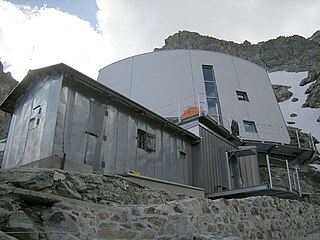
The Goûter Hut, is a mountain refuge in the French department of Haute-Savoie. It is located at a height of 3,835 metres (12,582 ft) on the Arete du Goûter in the municipality of Saint-Gervais-les-Bains. It overlooks the Glacier de Bionnassay, and is the highest wardened mountain hut in France.

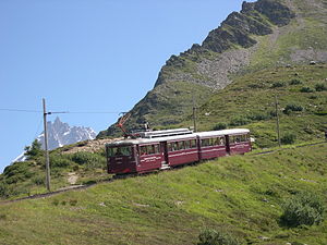
Gare du Nid d'Aigle is the terminus of the Tramway du Mont Blanc (TMB) from Saint-Gervais-les-Bains on the slopes of the Mont Blanc.
The Goûter Route is one of the two normal mountaineering routes used to reach the summit of Mont Blanc in the Alps, ascending to a height of 4,808 metres (15,774 ft). The route lies on the north side of the mountain, in France. Usually reckoned as the easiest route up Mont Blanc, it is extremely popular with mountaineers, seeing thousands of ascents per year.
Jean-Marc Peillex is a French local and regional politician from the DVD / Union of Democrats and Independents / Les Républicains, currently serving as Mayor of Saint-Gervais-les-Bains and Conseiller Général of the canton of Saint-Gervais, later Conseiller Départemental of the newly formed canton Mont-Blanc in the department of Haute-Savoie. In May 2014 he was re-elected for 6 years.

Chamonix-Mont-Blanc station is a railway station in the commune of Chamonix-Mont-Blanc, in the French department of Haute-Savoie. It is located on the 1,000 mm gauge Saint-Gervais–Vallorcine line of SNCF. The station is adjacent to the station of the Chemin de fer du Montenvers, which operates a rack railway to the Mer de Glace.