| Railway | Country | Range | Highest point | Highest elevation | Maximum incline | Gauge | Rack railway | Type | Notes |
|---|
| Jungfrau | Switzerland | Alps | Jungfraujoch | 3,454 m (11,332 ft) | 25% | 1,000 mm | Yes | Dead-end rail | Underground above 2,350 m, one of the highest railways in the world at the opening |
| Gornergrat | Switzerland | Alps | Gornergrat | 3,090 m (10,138 ft) | 20% | 1,000 mm | Yes | Dead-end rail | Highest open-air railway in Europe |
| Zugspitze | Germany | Alps | Schneefernerhaus | 2,650 m (8,694 ft) | 25% | 1,000 mm | Yes | Dead-end rail | Underground above 1,640 m, biggest height difference (1,945 m (6,381 ft)) |
| Mont Blanc | France | Alps | Nid d'Aigle | 2,372 m (7,782 ft) | 24% | 1,000 mm | Yes | Dead-end rail | |
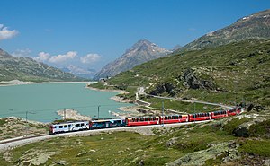
| Bernina | Switzerland/Italy | Alps | Ospizio Bernina | 2,253 m (7,392 ft) | 7% | 1,000 mm | No | Rail crossing | Highest rail crossing in Europe, open-air railway with the biggest height difference (1,824 m (5,984 ft)), highest point in Italy: 522 m |
| Brienz Rothorn | Switzerland | Alps | Brienzer Rothorn | 2,244 m (7,362 ft) | 25% | 800 mm | Yes | Dead-end rail | Not electrified |
| Riffelalp | Switzerland | Alps | Riffelalp Resort | 2,222 m (7,290 ft) | 5% | 800 mm | No | Dead-end rail | Not electrified |
| Furka Steam Railway | Switzerland | Alps | Furka railway station | 2,163 m (7,096 ft) | 11.8% | 1,000 mm | Yes | Rail crossing | Not electrified, seasonal operations |
| Pilatus Railway | Switzerland | Alps | Pilatus | 2,073 m (6,801 ft) | 48% | 800 mm | Yes | Dead-end rail | Steepest railway in the world [4] |
| Lauterbrunnen–Kleine Scheidegg–Grindelwald | Switzerland | Alps | Kleine Scheidegg | 2,061 m (6,762 ft) | 25% | 800 mm | Yes | Rail crossing | Rail crossing usually involves change of train at Kleine Scheidegg, the highest railway hub in Europe |
| Andermatt–Chur | Switzerland | Alps | Oberalp Pass | 2,033 m (6,670 ft) | 11% | 1,000 mm | Yes | Rail crossing | |
| Montreux–Glion–Rochers-de-Naye | Switzerland | Alps | Rochers de Naye | 1,968 m (6,457 ft) | 22% | 800 mm | Yes | Dead-end rail | |
| Schynige Platte | Switzerland | Alps | Schynige Platte | 1,967 m (6,453 ft) | 25% | 800 mm | Yes | Dead-end rail | |
| Vall de Núria | Spain | Pyrenees | Núria | 1,964 m (6,444 ft) | 15% | 1,000 mm | Yes | Dead-end rail | Highest railway in Europe outside the Alps |
| Artouste | France | Pyrenees | Station d'Artouste | 1,940 m (6,365 ft) | | 500 mm | No | Dead-end rail | Accessible only by cable car |
| Montenvers | France | Alps | Hotel du Montenvers | 1,913 m (6,276 ft) | 22% | 800 mm | Yes | Dead-end rail | |
| Les Montuires–Emosson | Switzerland | Alps | Les Montuires | 1,822 m (5,978 ft) | 1.46% | 600 mm | No | Dead-end rail | Part of the Parc d'attractions du Châtelard [5] |
| Albula | Switzerland | Alps | Albula Tunnel | 1,820 m (5,971 ft) | 3.5% | 1,000 mm | No | Rail crossing | |
| Cercedilla–Cotos | Spain | Central System | Cotos railway station | 1,818 m (5,965 ft) | | 1,000 mm | No | Dead-end rail | Highest railway operated by RENFE |
| Bex–Villars–Bretaye | Switzerland | Alps | Bretaye | 1,806 m (5,925 ft) | 20% | 1,000 mm | Yes | Dead-end rail | |
| Schneeberg | Austria | Alps | Schneeberg | 1,792 m (5,879 ft) | 19.6% | 1,000 mm | Yes | Dead-end rail | |
| Pontresina–Scuol-Tarasp | Switzerland | Alps | Pontresina | 1,774 m (5,820 ft) | 2.5% | 1,000 mm | No | Dead-end rail | Lowest point at the terminus station (Scuol-Tarasp) |
| Rigi | Switzerland | Alps | Rigi Kulm | 1,752 m (5,748 ft) | 25% | 1,435 mm | Yes | Rail crossing at Rigi Staffel, dead-end rail to the summit | Oldest mountain rack railway in Europe, rail crossing involves change of train at Rigi Staffel |
| Chur–Arosa | Switzerland | Alps | Arosa | 1,739 m (5,705 ft) | 6% | 1,000 mm | No | Dead-end rail | |
| Schafberg | Austria | Alps | Schafberg | 1,732 m (5,682 ft) | 25.5% | 1,000 mm | Yes | Dead-end rail | |
| Wendelstein | Germany | Alps | Wendelstein | 1,723 m (5,653 ft) | 23.7% | 1,000 mm | Yes | Dead-end rail | |
| Kukushka | Georgia | Lesser Caucasus | Bakuriani | 1,700 m (5,577 ft) | | 900 mm | No | Dead-end rail | Narrow-gauge railway line linking the town of Borjomi (820 m) to the ski resort of Bakuriani (1,700 m) |
| Grütschalp–Mürren | Switzerland | Alps | Mürren | 1,639 m (5,377 ft) | 5% | 1,000 mm | No | Dead-end rail | Accessible only by cable car |
| Landquart–Klosters–Davos | Switzerland | Alps | Davos Wolfgang | 1,625 m (5,331 ft) | 4.5% | 1,000 mm | No | Rail crossing | |
| Visp–Zermatt | Switzerland | Alps | Zermatt | 1,605 m (5,266 ft) | 12.5% | 1,000 mm | Yes | Dead-end rail | |
| Monte Generoso | Switzerland | Alps | Generoso Vetta | 1,601 m (5,253 ft) | 22% | 800 mm | Yes | Dead-end rail | |
| Cerdagne | France | Pyrenees | Bolquère-Eyne | 1,592 m (5,223 ft) | 6% | 1,000 mm | No | Rail crossing | |
| Portet-Saint-Simon–Puigcerdà | France/Spain | Pyrenees | Porté-Puymorens | 1,562 m (5,125 ft) | 4% | 1,435 mm | No | Rail crossing | Highest adhesion and standard gauge railway in Europe |
| Brig–Andermatt | Switzerland | Alps | Realp | 1,538 m (5,046 ft) | | 1,000 mm | Yes | Rail crossing | |
| Ripoll–Puigcerdà (es) | Spain | Pyrenees | Toses tunnel | 1,494 m (4,902 ft) | | 1,668 mm | No | Rail crossing | Highest adhesion and Iberian gauge Railway in Spain |
| Aigle–Leysin | Switzerland | Alps | Leysin Grand Hôtel | 1,450 m (4,757 ft) | 23% | 1,000 mm | Yes | Dead-end rail | |
| Göschenen–Andermatt | Switzerland | Alps | Andermatt | 1,436 m (4,711 ft) | 17.9% | 1,000 mm | Yes | Rail crossing | |
| Panoramique des Dômes | France | Massif Central | Puy de Dôme | 1,406 m (4,613 ft) | 20% | 1,000 mm | Yes | Dead-end rail | |
| Mont-Blanc Express | France/Switzerland | Alps | Vallorcine | 1,384 m (4,541 ft) | 9 % | 1,000 mm | No | Rail crossing | Operated by the Martigny–Châtelard and Saint-Gervais–Vallorcine railways |
| Brenner | Austria/Italy | Alps | Brenner | 1,371 m (4,498 ft) | 2.5% | 1,435 mm | No | Rail crossing | |
| Vevey–Les Pléiades | Switzerland | Alps | Les Pléiades | 1,360 m (4,462 ft) | 20% | 1,000 mm | Yes | Dead-end rail | |
| Madrid–Hendaye (es) | Spain/France | Central System | Herradón-La Cañada railway station [6] | 1,360 m (4,462 ft) | | 1,668 mm | No | Rail crossing | |
| Tatra | Slovakia | Tatra Mountains | Štrbské Pleso | 1,350 m (4,429 ft) | 15% | 1,000 mm | Yes | Rail crossing | |
| Fréjus | Italy/France | Alps | Fréjus Tunnel | 1,338 m (4,390 ft) | 3% | 1,435 mm | No | Rail crossing | |
| Arlberg | Austria | Alps | Arlberg Tunnel | 1,311 m (4,301 ft) | 3.1% | 1,435 mm | No | Rail crossing | |
| Villalba–Segovia (es) | Spain | Central System | Gudillos tunnel | 1,300 m (4,265 ft) | | 1,668 mm | No | Rail crossing | |
| Montreux–Lenk im Simmental line | Switzerland | Alps | Saanenmöser Pass | 1,279 m (4,196 ft) | 7% | 1,000 mm | No | Rail crossing | |
| León–Gijón (es) | Spain | Cantabrian Mountains | La Perruca tunnel | 1,278 m (4,193 ft) | | 1,668 mm | No | Rail crossing | |
| Sulmona–Isernia [7] | Italy | Apennines | Rivisondoli–Pescocostanzo | 1,268 m (4,160 ft) | | 1,435 mm | No | Rail crossing | |
| Septemvri–Dobrinishte | Bulgaria | Between Rhodope and Rila Mountains | Avramovo | 1,267 m (4,157 ft) | 3.2% | 760 mm | No | Rail crossing | Highest railway in the Balkan Peninsula |
| Ritten | Italy | Alps | Rappersbichl | 1,255 m (4,117 ft) | | 1,000 mm | No | Dead-end rail | Accessible by cable car |
| Lötschberg | Switzerland | Alps | Lötschberg Tunnel | 1,240 m (4,068 ft) | 2.7% | 1,435 mm | No | Rail crossing | Highest adhesion and standard gauge railway in Switzerland |
| Bergen | Norway | Scandinavian Mountains | Finse Tunnel | 1,237 m (4,058 ft) | | 1,435 mm | No | Rail crossing | Highest railway in Scandinavia |
| Nyon–St-Cergue–La Cure | Switzerland | Jura Mountains | Col de la Givrine | 1,228 m (4,029 ft) | 6% | 1,000 mm | No | Dead-end rail | Highest railway in the Jura Mountains |
| Tauern | Austria | Alps | Tauern Tunnel | 1,226 m (4,022 ft) | 3% | 1,435 mm | No | Rail crossing | |
| Sagunto–Zaragoza (es) | Spain | Iberian System | Puerto Escandón railway station | 1,218 m (3,996 ft) | | 1,668 mm | No | Rail crossing | |
| Madrid–Barcelona high-speed rail line | Spain | Iberian System | Somewhere between Layna and Arbujuelo during the brief pass of the line through Castile and León | 1,217 m (3,993 ft) | | 1,435 mm | No | Rail crossing | Highest high-speed rail line in Spain. Highest adhesion and standard gauge railway in Spain. According to Google Earth, around N 41.1085°, W 2.3673°, the line is at 1,230 m AMSL. Name of the location at the highest point (if it has any) needs to be confirmed by reliable sources. The kilometer point on which it is located could be an alternative. |
| Monastier–La Bastide-Saint-Laurent-les-Bains (fr) | France | Massif Central | Allenc | 1,215 m (3,986 ft) | 2.7 % | 1,435 mm | No | Rail crossing | |
| Erzberg (de) | Austria | Alps | Präbichl | 1,204 m (3,950 ft) | 7.1% | 1,435 mm | No | Rail crossing | |
| Veynes–Briançon (fr) | France | Alps | Briançon | 1,203 m (3,947 ft) | 2.5% | 1,435 mm | No | Dead-end rail | |
| Madrid–Asturias high-speed rail line | Spain | Central System | Guadarrama Tunnel | 1,200 m (3,937 ft) | | 1,435 mm | No | Rail crossing | High-speed rail line
|