
Monte Civetta is a prominent and major mountain of the Dolomites, in the Province of Belluno in northern Italy. Its north-west face can be viewed from the Taibon Agordino valley, and is classed as one of the symbols of the Dolomites.

Presanella is a mountain in the Adamello-Presanella range of the Italian Alps of northern Italy. Presanella has an elevation of 3,558 meters and is located in the Adamello Brenta National Park within the Trentino province of Italy.

The Zuckerhütl is a mountain in Tyrol, Austria. At 3,505 metres, it is the highest peak of the Stubai Alps and lies at the southern end of the Stubaital Valley.

The Grande Casse is the highest mountain of the Vanoise Massif in the Graian Alps in the region of Savoie, France. It is located in the heart of the Vanoise National Park, near the village of Pralognan-la-Vanoise, which is about 25 km southeast of the nearest town, Moûtiers. It has a steep 600 m high north face. The other sides of the mountain are more gentle, mostly consisting of broken rocks. A high ridge connects it to the nearby peak of Grande Motte. The ridge connecting the Grande Casse and the Grande Motte is the watershed between the Tarentaise Valley in the north and Maurienne valley to the south.

Cima di Castello is a mountain of the Bregaglia Range, located on the border between Italy and Switzerland. With a height of 3,379 metres (11,086 ft) above sea level, it is the second highest mountain in the Bregaglia Range. Its summit lies between the valleys of the Albigna and Forno Glacier and the valley of Val Mello.

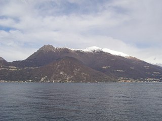
Monte Resegone or Resegone di Lecco, also known as Monte Serrada, is a mountain of the Bergamasque Prealps in Lombardy, northern Italy. It has an elevation of 1,875 m and is located on the border between the provinces of Bergamo and Lecco.

Cima Piazzi, Cima de' Piazzi, del Piazzi or di Piazzi (3,439m) is the highest mountain of the Livigno Alps in Lombardy, Italy. It has a summit elevation of 3,439 m (11,283 ft) above sea level and is located near to the town of Bormio. It has a beautiful and imposing north face, which is covered with ice, and three long ridges, and is glaciated on all sides.
Monte di Tremezzo is a mountain of the Lugano Prealps in Lombardy, Italy. It is the highest summit of a ridge just south of Porlezza commune, lying between Lake Lugano and Lake Como. Due to its modest height it is a relatively easy mountain to climb, but due to its great prominence it provides a good view across the lakes, and over to the High Alps; mountains as far away as Finsteraarhorn, Dom and Monte Leone can be seen on a clear day.
Monte Bondone is a mountain of Trentino, northern Italy, located west of the provincial capital of Trento. It has an elevation of 2,180 metres (7,152 ft) and includes a ski resort on one side. It is the highest mountain of the Garda Prealps and with a prominence of 1,685 metres (5,528 ft) qualifies as an Ultra. It lies between the Etschtal valley in the east and the Sarca valley in the west. Due to its location high above the city, it is often called the mountain of Trento.

Monte Pelmo is a mountain of the Dolomites, in the province of Belluno, Northeastern Italy.

Hohe Gaisl, (3,146m) is a mountain in the northern Dolomites, on the border of South Tyrol and Veneto, in northern Italy, located between the Braies Valley and the Val di Landro.

The Croce Rossa or Croix Rousse is a mountain of the Graian Alps, on the border between Piedmont, Italy and Savoie, France.

Tofana di Rozes is a mountain of the Dolomites in the Province of Belluno, Veneto, Italy. Located west of the resort of Cortina d'Ampezzo, the mountain's giant three-edged pyramid shape and its vertical south face, above the Falzarego Pass, makes it the most popular peak in the Tofane group, and one of the most popular in the Dolomites.

Tsanteleina (3,601m) is a mountain of the Graian Alps located on the border between Savoie, France and Aosta Valley, Italy. It lies at the head of the Val di Rhèmes, although the summit itself is hidden from view in the valley. The eastern side of the mountain lies within the Gran Paradiso National Park. The normal route to the summit is from the north as the paths on the other side of the mountain have been neglected due to the poor quality of the rock. The north face is also popular with ski mountaineers.

Becco di Mezzodì (2,603m) is a mountain of the Croda da Lago chain, a small mountain group in the central Dolomites. It is located above the resort of Cortina d'Ampezzo in Belluno, northern Italy. The mountain's name means Midday Peak in the local dialect, as the sun appears directly above the peak at midday from Cortina. The climb usually starts from the Refuge Croda da Lago on the road to the Giau Pass. Climbing gear and slings are required.

Rognosa di Sestriere is a mountain of the Cottian Alps in Piedmont, Italy.

Punta Lavina (3,308m) is a mountain of the Graian Alps located on the border of Aosta Valley and Piedmont, Italy. It is located between the Aostan Cogne Valley in the north and the Piedmontese Soana Valley in the South. The mountain has an elegant pyramidal shape which is easily recognisable from both Canavese and Turin. It lies entirely within the Gran Paradiso National Park.

Trogkofel is a mountain of the Carnic Alps lying on the border of Friuli, Italy and Carinthia, Austria. It is located on the main ridge of the Carnics between the Aip Valley to the south and the Gail Valley in the north, and is the second highest mountain on the eastern ridge after Gailtaler Polinik. The mountain is known as Crete Rosse, meaning Red Rocky Mountain in Friuli.

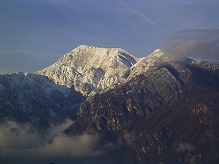
Peralba is a mountain of the Carnic Alps in Veneto, northeastern Italy, although its summit is only a few hundred metres from the Austrian border. It has a height of 2,694 m making it the second highest mountain of the Carnics, after Coglians. It lies on the main chain of the range, between the Austrian Lesachtal Valley in the north and the Italian Piave Valley in the south. The mountain resembles a huge cubic block of the stone, with a large summit plateau, and dominates the view from miles around.

Cima Bocche is a mountain of the Dolomites in Trentino, Italy. It is the highest peak of a small group that is located between the San Pellegrino Pass and the Predazzo valley. The mountain has a vertical 400m north face, whereas its southern slopes are far more gentle, making it an easy climb from this direction. Despite being geographically part of the Dolomites, the mountain is not geologically part of the range, as it is formed of Porphyry rather than dolomite.

