
Exploration of the higher region of the Alps by travellers from outside the immediate region only became popular from the 18th century. About 20 glacier passes were known before 1600, 25 more before 1700, and another 20 before 1800. While an attempt in 1689 to "re-open" the Col du Géant by Philibert-Amédée Arnod, an official from the duchy of Aosta, may be counted as having been made by a non-native, historical records do not show any further such activities until the last quarter of the 18th century. There are some records of very early ascents by non-natives, including that of the Rocciamelone in 1358 in fulfilment of a vow; that of the Mont Aiguille in 1492 by order of Charles VIII of France; and the ascent of the Gnepfstein, the lowest and the most westerly of the seven summits by Conrad Gessner in 1555.

The Aosta Valley is a mountainous autonomous region in northwestern Italy. It is bordered by Auvergne-Rhône-Alpes, France, to the west; by Valais, Switzerland, to the north; and by Piedmont, Italy, to the south and east. The regional capital is Aosta.

The Haute Route is the name given to a route undertaken on foot or by ski touring between the Mont Blanc in Chamonix, France, and the Matterhorn, in Zermatt, Switzerland.

The Grand Combin is a mountain massif in the western Pennine Alps in the canton of Valais. At a height of 4,309 metres (14,137 ft) the summit of Combin de Grafeneire is one of the highest peaks in the Alps and the second most prominent of the Pennine Alps. The Grand Combin is also a large glaciated massif consisting of several summits, among which three are above 4000 metres. The highest part of the massif is wholly in Switzerland, although the border with Italy lies a few kilometres south.
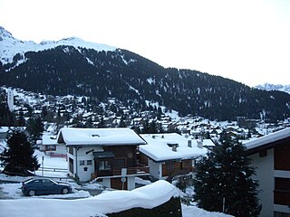
Verbier is a village located in south-western Switzerland in the canton of Valais. It is a holiday resort and ski area in the Swiss Alps and is recognised as one of the premier off-piste resorts in the world. Some areas are covered with snow all year. Skiers have settled in the Verbier area in order to take advantage of the steep slopes, varied conditions, and resort culture.

Arolla is a village in the municipality of Evolène in the Swiss canton of Valais. It is situated at the end of the Val d'Hérens, south of the cantonal capital, Sion.

Bionaz is a comune sparso which extends over 143 square kilometres (55 sq mi) of the North-Eastern Valpelline area of the Aosta Valley region of northwest Italy. The commune lies on the left side of the river Dora Baltea. The population of about 240 is dispersed among 20 or more small alpine villages and hamlets including Plan-de-Veyne, which is the main centre and the capoluogo. The commune belongs to the Unité des communes valdôtaines du Grand-Combin.

Émarèse is a town and comune in the Aosta Valley region of north-western Italy. It has 213 inhabitants.

Ollomont is a town and comune in the Aosta Valley region of north-west Italy.

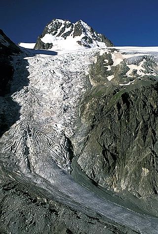
Mont Blanc de Cheilon is a mountain of the Pennine Alps, located in the Swiss canton of Valais. The mountain lies between the valleys of Bagnes and Arolla. Culminating at 3,870 metres above sea level, it is one of the highest summits between the Grand Combin to the west and the Dent Blanche to the east. The massif is glaciated, with the Cheilon Glacier to the north, the Giétro Glacier to the west, the Brenay Glacier to the south and the Tsijiore Nouve Glacier to the east.

The Buthier is a mountain torrent in north-west Italy. A left bank tributary of the Dora Baltea, its entire course lies within the Valpelline, a valley in the region of Aosta Valley.

Mont Gelé (3,518 m) is a mountain of the Pennine Alps, located on the border between Switzerland and Italy. It lies between the valleys of Bagnes and Valpelline, on the main Alpine watershed. It overlooks the Fenêtre de Durand from the east side.

Tête Blanche is a mountain of the Pennine Alps on the Swiss-Italian border. Its summit is the tripoint between the valleys of Hérens, Mattertal and Valpelline, thus forming the linguistic tri-point between French, German (Mattertal), and Italian -speaking areas.
The Becca de Corbassière is a mountain of the Pennine Alps, overlooking Fionnay in the canton of Valais. It lies at the northern end of the chain separating the valley of the Corbassière Glacier from the main valley of Bagnes, north of the Grand Combin.
The Arolla Glacier is a 4 km (2.5 mi) long glacier (2005) situated in the Pennine Alps in the canton of Valais in Switzerland. In 1973 it had an area of 13.17 km2 (5.08 sq mi).

Refuge Crête Sèche or Rifugio Crête Sèche is a shelter in the Alps of Italy near the border with Switzerland. More precisely, this refuge is located in the valley of Valpelline, a side valley of the Aosta Valley in the Italian Pennine Alps, at 2,410 metres (7,910 ft) above sea level. It lies on the slopes of Mont de Crête Sèche whose summit is at elevation 2,941 metres (9,649 ft).

The Grand Tournalin Refuge is a mountain hut located at an altitude of 2,550 meters in the Pennine Alps, within the Aosta Valley, Italy. It lies in the high Val d'Ayas, in the Nana valley, at the base of the Grand Tournalin mountain.
The Col de Chermotane is an Alpine pass located in the Swiss canton of Valais. With an elevation of 3,037 metres above sea level, the Col de Chermotane is the lowest pass between the valleys of Bagnes and Hérens. The pass lies a few kilometres north of the main chain of the Alps and is covered by the Otemma Glacier. It connects Chanrion to Arolla, both in the upper part of their valley.
The Col de Crête Sèche is a mountain pass in the Alps, located between Switzerland and Italy. It lies at a height of 2,896 metres (9,501 ft) above sea level, between the massifs of Mont Gelé and Bec d'Epicoune, in the Pennine Alps. It connects Fionnay in the Swiss canton of Valais on its northern side to Bionaz in the Italian region of the Aosta Valley on its southern side. The Col de Crête Sèche is the second-lowest pass between the valleys of Bagnes and Valpelline, after the Fenêtre de Durand which lies about one hundred metres lower west of Mont Gelé.

Corno Bussola is a 3,023 metres high peak on the Italian side of the Pennine Alps.


