
The Sesia is a river in Piedmont, north-western Italy, tributary to the Po.

The province of Vercelli is a province in the Piedmont region of Italy. Its capital is Vercelli.

Monte Rosa is a mountain massif in the eastern part of the Pennine Alps, on the border between Italy and Switzerland (Valais). The highest peak of the massif, amongst several peaks of over 4,000 m (13,000 ft), is the Dufourspitze, the second highest mountain in the Alps and western Europe, after Mont Blanc. The east face of the Monte Rosa towards Italy has a height of about 2,400 metres (7,900 ft) and is the highest mountain wall of the Alps.
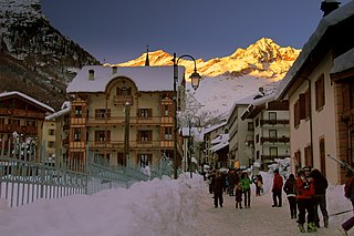
Alagna Valsesia is a comune and small village high in the Valsesia alpine valley in the province of Vercelli, Piedmont, northern Italy, a UNESCO World heritage site since 2013. It is a tourist place for mountaineering and winter sports, and it is internationally renowned for the freeride off-piste skiing. It is also the traditional starting point for the Margherita Hut climb, at 4,554 metres (14,941 ft) above sea level, the highest building in Europe. It was originally settled by Walser at the beginning of the 12th century. It is located at an elevation of 1,191 metres (3,907 ft) just south of the Monte Rosa, elevation 4,638 metres (15,217 ft) ; It is very close to Milan and to the international Milan–Malpensa Airport.
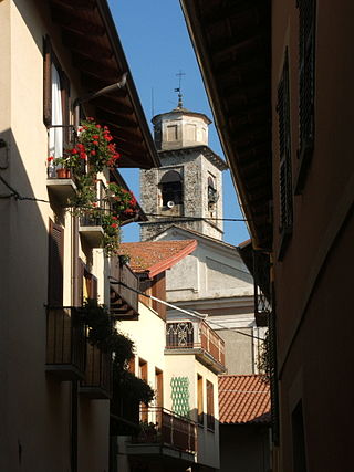
Varallo Sesia, pronunciation (Vhuh-rahl-loh) commonly known as Varallo, is a comune and town in the province of Vercelli in the Piedmont region of Italy. It is situated in Valsesia, at 450 metres (1,480 ft) above sea level and some 66 kilometres (41 mi) north-northeast of Vercelli and 55 kilometres (34 mi) northwest of Novara.

Borgosesia is a comune (municipality) in the Province of Vercelli in the Italian region Piedmont, located about 80 kilometres (50 mi) northeast of Turin and about 45 kilometres (28 mi) north of Vercelli.
Guardabosone is a comune (municipality) in the Province of Vercelli in the Italian region Piedmont, located about 80 kilometres (50 mi) northeast of Turin and about 45 kilometres (28 mi) northwest of Vercelli.

Riva Valdobbia is a fraction in the Province of Vercelli in the Italian region Piedmont, located about 90 kilometres (56 mi) north of Turin and about 70 kilometres (43 mi) northwest of Vercelli. It's an Italian town of 265 inhabitants located in the upper Valsesia, in the province of Vercelli, in Piedmont.

Antonio d'Enrico, called Tanzio da Varallo, or simply il Tanzio was an Italian painter of the late-Mannerist or early Baroque period.

The Sacred Mountain of Varallo is a Sacro Monte overlooking the town of Varallo Sesia in the province of Vercelli, Piedmont, northern Italy. It is the oldest Sacro Monte, founded in 1491 by Franciscan friar Bernardino Caimi. It is built on a natural terrace on the rocky slopes of Monte Tre Croci, on the left bank of the Sesia river where it leaves Val Mastallone. It is 600 m above sea level, 150 m above the historic centre of Varallo.

The Biellese Alps are a sub-range of the Pennine Alps located between Piemonte and Aosta Valley (Italy).

The Alpi Cusiane are a sub-range of the Pennine Alps located in Piemonte (Italy).

Corno Bianco is a mountain of the Pennine Alps. It's a popular climbing destination of Valsesia.

The Margherita Hut is a mountain hut belonging to the Italian Alpine Club, located on the summit of Punta Gnifetti of Monte Rosa, a mountain massif of the Alps lying near the border between Italy and Switzerland. At 4,554 metres (14,941 ft) above sea level, it is the highest building in Europe. It was originally opened in 1893 as a research station for high altitude medicine which it still is, but also serves as a simply equipped mountain hut for alpinists.

Val Vogna is a lateral valley of Valsesia, inside the municipality of Riva Valdobbia, Italy.

The Church of Our Lady of the Graces is a Gothic-style, Roman Catholic church in Varallo Sesia, province of Vercelli, region of Piedmont, Italy. The church was built, together with the adjacent Franciscan convent, by padre Bernardo Caimi between 1486 and 1493. At this time, the construction of the Sacro Monte was also beginning. In December 1931, Pope Pius XI gave the church the title of Minor Basilica.

The Monte Capio is a mountain in the Pennine Alps of north-western Italy; with an elevation of 2,172 m (7,126 ft) is one of the highest peaks of the Alpi Cusiane.

The Monte Capezzone is a mountain in the Pennine Alps of north-western Italy; with an elevation of 2,421 m (7,943 ft) is the highest peak of the Strona Valley.

Monte Tovo is a mountain of Piedmont, Italy, with an elevation of 1,386 metres (4,547 ft). It is located in the Pennine Alps, in the Province of Vercelli.

Corno di Faller, also known as Monte Turlo, or Fallerhorn in Walser language, is a mountain of Piedmont, Italy, with an elevation of 3,128 metres (10,262 ft).


