
Castor is a mountain in the Pennine Alps on the border between Valais, Switzerland and the Aosta Valley in Italy. It is the higher of a pair of twin peaks, the other being Pollux, named after the Gemini twins of Roman mythology. Castor's peak is at an elevation of 4,225 m (13,862 ft), and it lies between Breithorn and the Monte Rosa. It is separated from Pollux by a pass at 3,847 m (12,621 ft), named Passo di Verra in Italian and Zwillingsjoch in German.
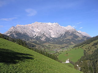
The Berchtesgaden Alps are a mountain range of the Northern Limestone Alps, named after the market town of Berchtesgaden located in the centre. It is crossed by the Austria–Germany border: the central part belongs to the Berchtesgadener Land district of southeastern Bavaria, Germany, while the adjacent area in the north, east and south is part of the Austrian state of Salzburg.

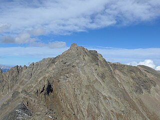
The Endkopf is a mountain in the Ötztal Alps in South Tyrol, Italy.

The Klopaierspitze is a peak in the Ötztal Alps on the border between Tyrol, Austria, and South Tyrol, Italy.

The Alpgundkopf is a mountain, 2,177 m high, in the Allgäu Alps. It lies in the Schafalpenköpfe group, northeast of the Roßgundkopf, from which it is separated by the Alpgundscharte col. To the southeast, 383 metres away, lies the lower Alpkopf and, 1,035 metres away, the small lake of Guggersee.

The Krottenspitze (2,551m) is a mountain in the Allgäu Alps. It is one of the few rocky summits of the main ridge that is visible from Oberstdorf.

The Mädelegabel is a 2,645 metre high mountain, made of main dolomite, in the Allgäu Alps near Oberstdorf. It is one of the best-known and most-climbed high peaks in the German Alps, Within the Allgäu Alps it is the fourth-highest summit, with rock faces up to 400 metres high. Together with the Trettachspitze and the Hochfrottspitze it forms the famous triumvirate of peaks on the main crest of the Allgäu. Its name comes from Mähder - a mown mountain pasture in the vicinity - and gabel from the appearance of the triumvirate to the north which recalls a fork. Originally the Mädelegabel was the name for all three peaks of the triumvirate; only later were they distinguished from one another by name.
The First Schafalpenkopf or Southwestern Schafalpenkopf is a 2,272-metre-high mountain in the Allgäu Alps. It is part of the Schafalpenköpfe and the Mindelheim Klettersteig.
The Urbeleskarspitze is a 2,632-metre-high mountain peak in the Allgäu Alps. It lies within Austria in the state of Tyrol and is the fifth-highest summit in the Allgäu Alps and the second-highest peak in the Hornbach chain. Its neighbours in the Hornbach chain are the Bretterspitze to the southwest and the Zwölfer Spitze to the northeast.

The Hagen Mountains are a subrange of the Berchtesgaden Alps. They lie mainly in the Austrian state of Salzburg, the western quarter is in the Bavarian county of Berchtesgadener Land. The steep western flanks of the Hagen lie in Bavaria and drop 1,700 metres (5,580 ft) in height to the basin of the Berchtesgadener Königssee.

The Innere Wetterspitze is a mountain, 3,053 metres high, in the Stubai Alps in the Austrian state of Tyrol. It lies between the Stubai and Gschnitztal valleys, rising to the north of and above the col of Simmingjöchl and is separated by the Lautererseejoch from the rather higher Äußere Wetterspitze (3,070 m). The two Wetterspitzen sit on the Habichtkamm, a mountain ridge that branches off the main chain of the Alps near the Feuerstein and heads northeastwards to the Elferspitze.

The Schartschrofen is a rocky summit, 1,968 m high, in the Tannheim Mountains, a sub-group of the Allgäu Alps. It lies northwest of the Rote Flüh and south of the col of Füssener Jöchl.

The Kreuzkarspitze is a 2,587-metre-high Austrian mountain in the Hornbach chain of the Allgäu Alps.

The Bratschenköpfe, consisting of the Großer Bratschenkopf and Kleiner Bratschenkopf, are two peaks in the Hochkönig massif in the Berchtesgaden Alps. The lie in the district of St. Johann im Pongau in the Austrian state of Salzburg.
The Lamkopf is a mountain, 2,846 m (AA), in the Hochkönig massif within the Berchtesgaden Alps. It lies in the Zell am See in the Austrian state of Salzburg.

The Hochseiler is a mountain, 2,793 m (AA), in the Hochkönig massif within the Berchtesgaden Alps. It lies on the boundary between the districts of Zell am See and St. Johann im Pongau in the Austrian state of Salzburg.

The Mühlsturzhörner are two summits in the Reiter Alm in the Berchtesgaden Alps in the Upper Bavarian county of Berchtesgadener Land. The Großes Mühlsturzhorn is 2,234 m above sea level (NHN) and its top is around 300 metres southeast of the Stadelhorn, not far from the border between Bavaria and Salzburg in Austria. The Kleines Mühlsturzhorn is located 280 metres east-northeast and has a height of 2,141 m above NHN.
The Zwieselbacher Rosskogel is a double peak in the northern Stubai Alps in the Austrian state of Tyrol. Its summit offers a sweeping panorama to the north because no other higher mountains impede the view. To the south, by contrast, the view is restricted by higher summits in the Stubai Alps. The first well known ascent took place on 23 August 1881 by Ludwig Purtscheller accompanied by chamois hunter Franz Schnaiter from Zirl.

