
The Glarus Alps are a mountain range in central Switzerland. They are bordered by the Uri Alps and the Schwyz Alps to the west, the Lepontine Alps to the south, the Appenzell Alps to the northeast. The eastern part of the Glarus Alps contains a major thrust fault that was declared a geologic UNESCO World Heritage Site.

The Alpine Rhine Valley is a glacial alpine valley, formed by the part of the Alpine Rhine between the confluence of the Anterior Rhine and Posterior Rhine at Reichenau and the Alpine Rhine's mouth at Lake Constance. It covers three countries and the full length of the Alpine Rhine is 93.5 km.
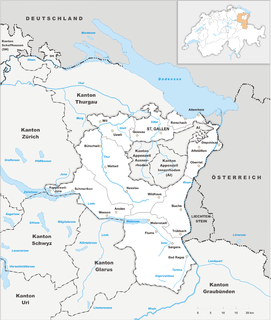
The canton of St. Gallen, also canton of St Gall, is a canton of Switzerland. The capital is St. Gallen.

Thurgau, anglicized as Thurgovia, more formally the Canton of Thurgau, is one of the 26 cantons forming the Swiss Confederation. It is composed of five districts and its capital is Frauenfeld.

St. Gallen or traditionally St Gall, in German sometimes Sankt Gallen is a Swiss city and the capital of the canton of St. Gallen. It evolved from the hermitage of Saint Gall, founded in the 7th century. Today, it is a large urban agglomeration and represents the center of eastern Switzerland. Its economy consists mainly of the service sector. The city is home of the University of St. Gallen, one of the best business schools in Europe.

Hulftegg Pass is a mountain pass between the cantons of Zürich and St. Gallen in Switzerland.

The Ringelspitz is a mountain of the Glarus Alps, located on the border between the Swiss cantons of St. Gallen and Graubünden. Reaching a height of 3,248 metres above sea level, it is the highest summit in the canton of St. Gallen. It is split between three municipalities: Pfäfers, Trin and Tamins (Graubünden).
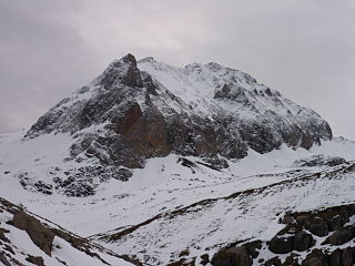
The Pizol is a mountain in the Glarus Alps of northeastern Switzerland, overlooking Wangs in the canton of St. Gallen. At 2,844 metres above sea level, it is the highest summit of the chain separating the valleys of the Seez and the Tamina rivers, and the highest mountain lying entirely within the canton of St. Gallen.

Piz Sardona is a mountain in the Glarus Alps, on the border between the cantons Glarus and St. Gallen. The 3,056 metre high mountain overlooks the valleys of Elm (Glarus) and Calfeisen. Less than one kilometre south of the summit lies the tripoint between the cantons of Glarus, St. Gallen and Graubünden. The summit itself is the northernmost point above 3,000 metres in Switzerland.
The Gamsberg is a mountain in the Appenzell Alps, overlooking the region of Walenstadt in the canton of St. Gallen. Located in the Alvier group it is the culminating point of the range lying between Lake Walenstadt and Toggenburg.
The Wissgandstöckli is a mountain of the Glarus Alps, located on the border between the Swiss cantons of Glarus and St. Gallen. It lies approximately halfway between Matt and Weisstannen.

The Foostock, also known as the Ruchen, is a mountain of the Glarus Alps, located on the border between the Swiss cantons of Glarus and St. Gallen. It lies north of Piz Sardona, on the range that separates the Sernftal from the Weisstannental.

The Calanda is a mountain in the Glarus Alps with two main peaks: Haldensteiner Calanda and Felsberger Calanda, both located on the border between the cantons of St. Gallen and Graubünden in eastern Switzerland. It looms over Chur, the capital city of Graubünden.
The Hochfinsler is a mountain of the Glarus Alps, located south of Flums in the canton of St. Gallen. It lies on the range north of the Wissgandstöckli, that separates the Schilstal from the Weisstannental.
The Fulfirst is a mountain of the Appenzell Alps, located north of Flums in the canton of St. Gallen. It lies in the Alvier group, between the Walensee and the Rhine Valley.
The Hangsackgrat is a mountain of the Glarus Alps, located south of Weisstannen in the canton of St. Gallen. It lies on the range east of Piz Sardona, that separates the Weisstannental from the Calfeisental.
The Zanaihorn is a mountain of the Glarus Alps, located north of Vättis in the canton of St. Gallen. It lies on the range east of the Pizol, between the valleys of the Zanaibach and the Tersolbach.

The Gauschla is a mountain of the Appenzell Alps, located north of Sargans in the canton of St. Gallen, Switzerland. It lies near the southern end of the range between the Walensee and the Rhine Valley, and one kilometre south-east of the Alvier. Just 600 metres south-east of the Gonschla, and clearly seen from the Rhine Valley, is the Girrenspitz.

The Leistchamm is a mountain of the Appenzell Alps, located east of Amden in the canton of St. Gallen. It lies at the western end of the range overlooking the Walensee, named Churfirsten.

The Foo Pass is a mountain pass of the Glarus Alps, located on the border between the Swiss cantons of St. Gallen and Glarus, at an elevation of 2,223 m (7,293 ft). It crosses the col between the peaks of Foostock and Piz Sardona.

