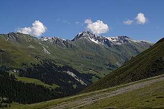
The Glarus Alps are a mountain range in central Switzerland. They are bordered by the Uri Alps and the Schwyz Alps to the west, the Lepontine Alps to the south, the Appenzell Alps to the northeast. The eastern part of the Glarus Alps contains a major thrust fault that was declared a geologic UNESCO World Heritage Site.

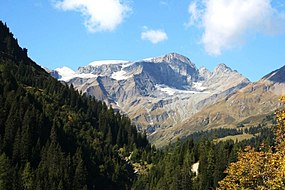
The Tödi, is a mountain massif and with the mountain peak Piz Russein the highest mountain in the Glarus Alps and the highest summit in the canton of Glarus, Switzerland. It is located on the border between the cantons of Graubünden, to the south, and Glarus, to the north, close to the point where those two cantons meet the canton of Uri, to the west. Although not the culminating point of Graubünden, it is its highest peak outside the Bernina range.
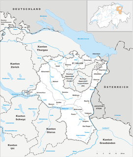
The canton of St. Gallen, also canton of St Gall, is a canton of Switzerland. The capital is St. Gallen.
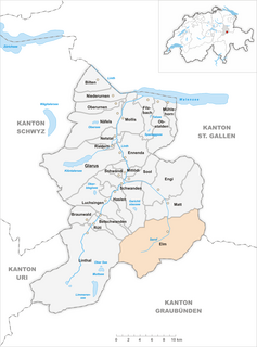
Elm is a village, and former municipality, in the municipality of Glarus Süd and canton of Glarus in Switzerland. Elm lies in the valley of the Sernf river, and consists of the village of Elm itself, and the hamlets of Sulzbach, Schwändi, Müsli, Untertal, Vogelsang, Töniberg, Obmoos, Steinibach and Wald.
The Tamina is a river in Switzerland that originates on the flanks of Piz Sardona in the Glarus Alps and flows eastwards and northwards to finally merge with the Alpine Rhine after about 18 km total length.

The Ringelspitz is a mountain of the Glarus Alps, located on the border between the Swiss cantons of St. Gallen and Graubünden. Reaching a height of 3,248 metres above sea level, it is the highest summit in the canton of St. Gallen. It is split between three municipalities: Pfäfers, Trin and Tamins (Graubünden).

The Hausstock is a mountain in the Glarus Alps, at an elevation of 3,158 m (10,361 ft) on the border between the cantons of Glarus and Graubünden. It overlooks the valleys of Linth and Sernf rivers in Glarus, and the valley of the Vorderrhein river in Graubünden. The Hausstock was the site of the 1799 withdrawal of the Russian army under General Alexander Suvorov. A well-known destination already in the nineteenth century with British and American climbers, the mountain remains popular with mountain climbers and skiers.

The Vorab is a mountain of the Glarus Alps, located on the border between the cantons of Glarus and Graubünden. The summit is also named Bündner Vorab to distinguish it from a lower summit named Glarner Vorab. A glacier runs down its eastern face where the valley continues a moderate inclination down towards Flims, where it can be seen for example from Caumasee. It cannot be seen from the adjacent municipalities on the south though. The northwestern face however consists of a sheer drop towards Elm.

Piz Segnas is a mountain in the Glarus Alps, located on the border between the cantons of Glarus and Graubünden. Piz Sardona is on the same ridge to the north, from where the Trinserhorn or Piz Dolf lies to the southeast. The Tschingelhoerner with the famous Martinsloch lies to the west, with the Pass dil Segnas between the two mountains.

The Glarus thrust is a major thrust fault in the Alps of eastern Switzerland. Along the thrust the Helvetic nappes were thrusted more than 100 km to the north over the external Aarmassif and Infrahelvetic complex. The thrust forms the contact between older (Helvetic) Permo-Triassic rock layers of the Verrucano group and younger (external) Jurassic and Cretaceous limestones and Paleogene flysch and molasse.

The Bützistock is a mountain of the Glarus Alps. It lies on the border between the cantons of Glarus and St. Gallen in Eastern Switzerland. The top is 2,496 m (8,189 ft) above sea level or 513 meters above the surrounding terrain. The width at the base is 18 km.

The Foostock, also known as the Ruchen, is a mountain of the Glarus Alps, located on the border between the Swiss cantons of Glarus and St. Gallen. It lies north of Piz Sardona, on the range that separates the Sernftal from the Weisstannental.

The Laaxer Stöckli is a 2,898 metre-high mountain of the Glarus Alps, located on the border between the cantons of Glarus and Graubünden in Eastern Switzerland. It lies approximately halfway between the Vorab and Piz Segnas.

The Tschingelhörner are a chain of mountain peaks in the Glarus Alps, located on the border between the Swiss cantons of Glarus and Graubünden. They are composed of several summits on a 1 km long ridge, of which the highest is named Grosses Tschingelhorn. The mountain is located between Elm and Flims, west of the Segnas Pass. East of the main summit is the Martinsloch, a 6-by-18-metre (20-by-60 ft) triangular breakthrough, or hole, through which the sun shines at particular times of the year.

Piz Dolf (Romansh) or Trinserhorn (German) is a mountain of the Glarus Alps, located on the border between the cantons of St. Gallen and Graubünden.
The Sazmartinshorn is a mountain of the Glarus Alps, overlooking St. Martin and the lake of Gigerwald in the canton of St. Gallen. It lies on the range east of Piz Sardona, that separates the Weisstannental from the Calfeisental. After the Pizol, the Sazmartinshorn is the second highest mountain lying entirely within the canton of St. Gallen.
The Hangsackgrat is a mountain of the Glarus Alps, located south of Weisstannen in the canton of St. Gallen. It lies on the range east of Piz Sardona, that separates the Weisstannental from the Calfeisental.
The Tristelhorn is a mountain of the Glarus Alps, located on the border between the Swiss cantons of St. Gallen and Graubünden. Reaching a height of 3,114 metres above sea level, it is one of the highest summits in the canton of St. Gallen.

The Foo Pass is a mountain pass of the Glarus Alps, located on the border between the Swiss cantons of St. Gallen and Glarus, at an elevation of 2,223 m (7,293 ft). It crosses the col between the peaks of Foostock and Piz Sardona.