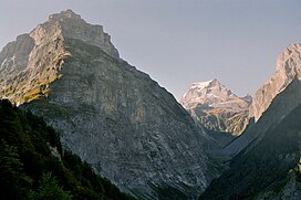
The Tödi, is a mountain massif and with the mountain peak Piz Russein the highest mountain in the Glarus Alps and the highest summit in the canton of Glarus, Switzerland. It is located on the border between the cantons of Graubünden, to the south, and Glarus, to the north, close to the point where those two cantons meet the canton of Uri, to the west. Although not the culminating point of Graubünden, it is its highest peak outside the Bernina range.

Vinson Massif is a large mountain massif in Antarctica that is 21 km (13 mi) long and 13 km (8 mi) wide and lies within the Sentinel Range of the Ellsworth Mountains. It overlooks the Ronne Ice Shelf near the base of the Antarctic Peninsula. The massif is located about 1,200 kilometres (750 mi) from the South Pole. Vinson Massif was discovered in January 1958 by U.S. Navy aircraft. In 1961, the Vinson Massif was named by the Advisory Committee on Antarctic Names (US-ACAN), after Carl G. Vinson, United States congressman from the state of Georgia, for his support for Antarctic exploration. On November 1, 2006, US-ACAN declared Mount Vinson and Vinson Massif to be separate entities. Vinson Massif lies within the Chilean claim under the Antarctic Treaty System.

The Diablerets are a huge ice-covered mountain massif of the Alps, culminating at the Sommet des Diablerets at 3,210 metres (10,530 ft) above sea level and straddling the border between the Swiss cantons of Vaud (VD) and Valais (VS). The northeastern part of the massif stretches also into the canton of Bern (BE).

The Brienzer Rothorn is a mountain of the Emmental Alps, in Switzerland. With an elevation of 2,350 metres (7,710 ft) above sea level, the Brienzer Rothorn is the highest summit of the range. To its west lies the Tannhorn, whilst to its east are Arnihaaggen, Höch Gumme and the Brünig Pass. On its south side it overlooks Lake Brienz, whilst to the north it looks out over the Waldemme valley.

The Twelve Bens or Twelve Pins, also called the Benna Beola is a mountain range of mostly sharp-peaked quartzite summits and ridges in the Connemara National Park in County Galway, in the west of Ireland. The widest definition of the range includes the Garraun Complex to the north as well as several isolated peaks to the west, and is designated a 16,163-hectare Special Area of Conservation.

Piz Bernina is the highest mountain in the Eastern Alps, the highest point of the Bernina Range, and the highest peak in the Rhaetian Alps. It rises 4,048.6 m (13,283 ft) and is located south of Pontresina and near the major Alpine resort of St. Moritz, in the Engadin valley. It is also the most easterly mountain higher than 4,000 m (13,000 ft) in the Alps, the highest point of the Swiss canton of Graubünden, and the fifth-most prominent peak in the Alps. Although the summit lies within Switzerland, the massif is on the border with Italy. The "shoulder" known as La Spedla is the highest point in the Italian Lombardy region.

The Grauspitz is a mountain in the Rätikon range of the Alps, located on the border between Liechtenstein and Switzerland. With an elevation of 2,599 metres (8,527 ft) above sea level, the Grauspitz is the highest mountain in Liechtenstein. It is also the highest summit of the Rätikon range west of the Schesaplana massif.

Monte Rosa is a mountain massif in the eastern part of the Pennine Alps. It is between Italy's and Switzerland's (Valais). Monte Rosa is the second highest mountain in the Alps and western Europe, after Mont Blanc.

The Grand Combin is a mountain massif in the western Pennine Alps in the canton of Valais. At a height of 4,314 metres (14,154 ft) the summit of Combin de Grafeneire is one of the highest peaks in the Alps and the second most prominent of the Pennine Alps. The Grand Combin is also a large glaciated massif consisting of several summits, among which three are above 4000 metres. The highest part of the massif is wholly in Switzerland, although the border with Italy lies a few kilometres south.

Mweelrea at 814 metres (2,671 ft), is the 26th-highest peak in Ireland on the Arderin scale, and the 34th-highest peak on the Vandeleur-Lynam scale. Mweelrea is situated near the apex of a "horseshoe-shaped" massif that includes the peaks of Ben Lugmore and Ben Bury, and which is located between Killary Harbour and Doo Lough, in Mayo, Ireland. Mweelrea is the provincial top for Connacht, and is noted for its southeastern cliff lined corries, and its views. The massif is called the Mweelrea Mountains or the Mweelrea Range.

Mullaghcleevaun at 849 metres (2,785 ft), is the 15th–highest peak in Ireland on the Arderin scale, and the 20th–highest peak on the Vandeleur-Lynam scale. Mullaghcleevaun is in the central sector of the Wicklow Mountains range, in Wicklow, Ireland; it is the 2nd highest peak in Wicklow after Lugnaquilla. Mullaghcleevaun lies on the main "central spine" of the whole range that runs from Kippure in the north, to Lugnaquillia in the south; and in particular, it lies on the continuous "central boggy ridge" that runs from the Sally Gap to Tonelagee.

The Glärnisch is a mountain massif of the Schwyz Alps, overlooking the valley of the Linth in the Swiss canton of Glarus. It consists of several summits, of which the highest, Bächistock, is 2,915 metres above sea level. Until 2013, the highest point was considered to be an unnamed point with a summit cross at 2,914 metres. The other main summits are Vrenelisgärtli and the Ruchen.
The Sustenhorn is a 3,502-metre-high (11,490 ft) mountain in the Uri Alps, located on the border between the cantons of Bern and Uri. It overlook Susten Pass from the south.

The Ringelspitz is a mountain of the Glarus Alps, located on the border between the Swiss cantons of St. Gallen and Graubünden. Reaching a height of 3,248 metres above sea level, it is the highest summit in the canton of St. Gallen. It is split between three municipalities: Pfäfers, Trin and Tamins (Graubünden).

Piz Sardona is a mountain in the Glarus Alps, on the border between the cantons Glarus and St. Gallen. The 3,056 metre high mountain overlooks the valleys of Elm (Glarus) and Calfeisen. Less than one kilometre south of the summit lies the tripoint between the cantons of Glarus, St. Gallen and Graubünden. The summit itself is the northernmost point above 3,000 metres in Switzerland.

The Kärpf is a mountain in the Glarus Alps, at an elevation of 2,794 m (9,167 ft). The Kärpf is the highest point of the massif lying north of Richetli Pass. This range separates the two main valleys of Glarus: the main Linth valley with the village of Linthal on the west and the Sernftal with the village of Elm on the east.

The Gross Lohner, is a limestone mountain of the Bernese Alps, located between Adelboden and Kandersteg in the Bernese Oberland. The main summit has an elevation of 3,048.7 metres (10,002 ft) above sea level and is distinguished by the name Vorder Lohner. The mountain features several other peaks, from east to west:

Binn Mhór is one of the Maumturk Mountains of Connemara in County Galway, Ireland. At 661 metres (2,169 ft), it is the third-highest of the Maumturks, the 140th-highest peak in Ireland on the Arderin list, and 171st-highest on the Vandeleur-Lynam list. Binn Mhór is on the southern side of the pass of Máméan, on a small massif that includes Mullach Glas and Corcogemore ; this massif is at the far southeastern sector of the long north-west to south-east spine of the Maumturks.
The Schibe is a mountain of the Glarus Alps, located south of Linthal in the canton of Glarus. It lies north of the Bifertenstock, on the range separating the Sand valley from the Limmeren valley that also includes the Selbsanft.

Ben Lugmore at 803 metres (2,635 ft) is the 29th-highest peak in Ireland on the Arderin scale, and the 37th-highest peak on the Vandeleur-Lynam scale. It is in a horseshoe-shaped massif that includes the slightly higher peak of Mweelrea at 814 metres (2,671 ft), the highest mountain in the Irish province of Connacht. The massif is between Killary Harbour and Doo Lough, in Mayo.