The Tödi, is a mountain massif and with the mountain peak Piz Russein the highest mountain in the Glarus Alps and the highest summit in the canton of Glarus, Switzerland. It is located on the border between the cantons of Graubünden, to the south, and Glarus, to the north, close to the point where those two cantons meet the canton of Uri, to the west. Although not the culminating point of Graubünden, it is its highest peak outside the Bernina range.
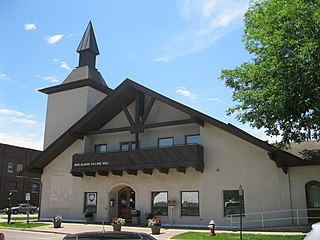
New Glarus is a village in Green County, Wisconsin, United States at the intersection of Wisconsin Highways 69 and 39. It has a population of 2,172 according to the 2010 census. Since 2000 it has had a population growth of 2.9 percent. The village, and the town that surrounds it, were named after the canton of Glarus in eastern Switzerland. The community was founded in 1845 by immigrants from that canton and was incorporated in 1901.

Engi is a village, and former municipality, in the municipality of Glarus Süd and canton of Glarus in Switzerland. The village lies in the valley of the Sernf river, and consists of the three adjacent village parts of Engi-Vorderdorf, Engi-Dörfli and Engi-Hinterdorf.

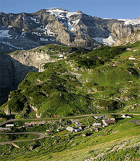
Klausen Pass is a high mountain pass in the Swiss Alps connecting Altdorf in the canton of Uri with Linthal in the canton of Glarus. Somewhat unusually, the boundary between the two cantons does not lie at the summit of the pass, but some 8 kilometres (5.0 mi) down the slope towards Linthal, with the summit being in Uri.
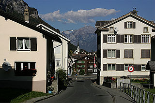
Linthal is a village, and former municipality, in the municipality of Glarus Süd and canton of Glarus in Switzerland. The village lies near the head of the valley of the Linth river, and at the foot of the Klausen Pass into the canton of Uri. It is the terminus of the railway line that traverses the length of Glarus.

Betschwanden is a village, and former municipality, in the municipality of Glarus Süd and canton of Glarus in Switzerland.

Luchsingen is a village, and former municipality, in the municipality of Glarus Süd and canton of Glarus in Switzerland.

Matt is a village, and former municipality, in the municipality of Glarus Süd and canton of Glarus in Switzerland. Matt lies in the valley of the Sernf river, and consists of the village of Matt itself, and the mountain hamlet of Weissenberge.

Sool is a village, and former municipality, in the municipality of Glarus Süd and canton of Glarus in Switzerland.

Schwanden is a village, and former municipality, in the municipality of Glarus Süd and canton of Glarus in Switzerland.

Schwändi is a village, and former municipality, in the municipality of Glarus Süd and canton of Glarus in Switzerland.

Diesbach is a village, and former municipality, in the municipality of Glarus Süd and canton of Glarus in Switzerland.
The Clariden is a mountain in the Glarus Alps, located at an elevation of 3,267 m (10,719 ft) between the Swiss cantons of Uri and Glarus. While on the north the Clariden overlooks the 1,948 m (6,391 ft) high Klausen Pass, the south side is covered by large glaciers. The Hüfifirn on the west is drained by the Chärstelenbach, a tributary of the Reuss that eventually flows into Lake Lucerne. The Claridenfirn on the east is drained by the Linth that eventually flows into Lake Zürich.

The Kärpf is a mountain in the Glarus Alps, at an elevation of 2,794 m (9,167 ft). The Kärpf is the highest point of the massif lying north of Richetli Pass. This range separates the two main valleys of Glarus: the main Linth valley with the village of Linthal on the west and the Sernftal with the village of Elm on the east.

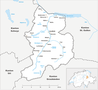
Glarus Süd is a municipality in the Swiss canton of Glarus. It comprises the upper Linth valley, and the entire Sernf valley, and includes the villages of Betschwanden, Braunwald, Diesbach, Elm, Engi, Haslen, Hätzingen, Leuggelbach, Linthal, Luchsingen, Matt, Mitlödi, Nidfurn, Rüti, Schwanden, Schwändi and Sool.

The Gulderstock is a mountain of the Glarus Alps, located north of Matt in the canton of Glarus. It lies south of the Magerrain, on the range between the valleys of Mülibach and Chrauchtal.
The S25 is a regional railway line of the S-Bahn Zürich on the Zürcher Verkehrsverbund (ZVV), Zürich transportation network, and is one of the network's lines connecting the cantons of Zürich with Schwyz, Glarus and St. Gallen. The line was introduced in July 2014, and replaces the less frequent Glarner Sprinter train.