Bodenschneid

Last updated
Bodenschneid
Bodenschneid-1.jpg
The Bodenschneid and Bodenschneidhaus (in the bowl to the right)
Highest point
Elevation 1,667.7 m (5,471 ft)
Coordinates 47°40′19″N11°50′17″E / 47.67194°N 11.83806°E / 47.67194; 11.83806 Coordinates: 47°40′19″N11°50′17″E / 47.67194°N 11.83806°E / 47.67194; 11.83806
Geography
Bavaria relief location map.jpg
Red triangle with thick white border.svg
Bodenschneid
Parent range Mangfall Mountains

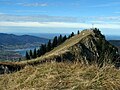
The Bodenschneid is a 1,668 m high mountain in the Schliersee Mountains in the Mangfall range in the German Free State of Bavaria.

Contents

Location and area

The Bodenschneid rises between the lakes of Tegernsee, Schliersee and Spitzingsee and lies in the southern part of the district of Miesbach right on the boundary between the parishes of Kreuth to the west and Schliersee to the east.

The Bodenschneid is long ridge, treeless at the top, with steep crags in the north. Another ridge, the Peißenberg, runs away from the summit to the northwest to the less well-known peaks of Rinnerspitz, Wasserspitz and Rainerkopf.

Ascent

The summit may be reached by foot from Fischhausen-Neuhaus (on the southern shore of Schliersee), from Spitzingsee, from the Suttengebiet (Moni Alm) or from Enterrottach (southeast of Tegernsee, parish of Rottach-Egern). Around 300 m below its highest point is Rettenböck Alm where there is an accommodation hut, Bodenschneidhaus, belonging to the German Alpine Club and which is open all-year round. The shortest ascent, from the Stümpfling (chairlifts from Sutten and Spitzing) over the gently ascending southern ridge, takes an hour.

Even in winter many ski tourers and snowshoe hikers make their way to the top from Fischhausen via the Bodenschneidhaus. This is the classic ascent, running initially through woods to the hut and finally climbing steeply up to the open summit.

History

The poacher, Georg Jennerwein, was shot on the Peißenberg on 6 November 1877.

Sources

Related Research Articles

Zugspitze Highest peak of the Wetterstein Mountains (Eastern Alps)

The Zugspitze, at 2,962 m (9,718 ft) above sea level, is the highest peak of the Wetterstein Mountains as well as the highest mountain in Germany. It lies south of the town of Garmisch-Partenkirchen, and the Austria–Germany border runs over its western summit. South of the mountain is the Zugspitzplatt, a high karst plateau with numerous caves. On the flanks of the Zugspitze are three glaciers, including the two largest in Germany: the Northern Schneeferner with an area of 30.7 hectares and the Höllentalferner with an area of 24.7 hectares. The third is the Southern Schneeferner which covers 8.4 hectares.

Grossglockner The highest mountain in Austria

The Grossglockner is, at 3,798 metres above the Adriatic (12,461 ft), the highest mountain in Austria and the highest mountain in the Alps east of the Brenner Pass. It is part of the larger Glockner Group of the Hohe Tauern range, situated along the main ridge of the Central Eastern Alps and the Alpine divide. The Pasterze, Austria's most extended glacier, lies on the Grossglockner's eastern slope.

Grosses Fiescherhorn

Grosses Fiescherhorn is a mountain peak of the Bernese Alps, located on the border between the cantons of Bern and ValaisValais, halfway between the Mönch and the Finsteraarhorn. At 4,049 metres (13,284 ft) above sea level, its summit culminates over the whole Fiescherhorn massif, which is also composed of the slightly lower Hinteres Fiescherhorn to the south and Kleines Fiescherhorn to the east. From the north both are well hidden behind other mountain peaks and can only been seen from Isch in Grindelwald. The mountain is shared between the municipalities of Grindelwald and Fieschertal.

Ortler

Ortler is, at 3,905 m (12,812 ft) above sea level, the highest mountain in the Eastern Alps outside the Bernina Range. It is the main peak of the Ortler Range. It is the highest point of the Southern Limestone Alps, of South Tyrol in Italy, of Tyrol overall, and, until 1919, of the Austrian-Hungarian empire. In German the mountain is commonly referred to as "König Ortler", like in the unofficial hymn of South Tyrol, the Bozner Bergsteigerlied.

Dom (mountain) Mountain in the Pennine Alps, Switzerland

The Dom is a mountain of the Pennine Alps, located between Randa and Saas-Fee in the canton of Valais in Switzerland. With a height of 4,545 m (14,911 ft), it is the seventh highest summit in the Alps, overall. Based on prominence, it can be regarded as the third highest mountain in the Alps, and the second highest in Switzerland, after Monte Rosa. The Dom is the main summit of the Mischabel group, which is the highest massif lying entirely in Switzerland.

Schliersee Place in Bavaria, Germany

Schliersee is a small town (Markt) and a municipality in the district of Miesbach in Bavaria in Germany. It is named after the nearby Lake Schliersee. It comprises the districts Schliersee (town), Westenhofen, Neuhaus, Fischhausen, Josefsthal and Spitzingsee.

Ober Gabelhorn

The Ober Gabelhorn is a mountain in the Pennine Alps in Switzerland, located between Zermatt and Zinal.

Signalkuppe

The Signalkuppe also known as Punta Gnifetti is a peak in the Pennine Alps on the border between Italy and Switzerland. It is a subpeak of Monte Rosa. The mountain is named after 'the Signal', a prominent gendarme atop the east ridge, named Cresta Signal.

Mont Dolent Mountain in the Mont Blanc massif

Mont Dolent is a mountain in the Mont Blanc massif and lies on the border between Italy, Switzerland and France.

Wetterstein

The Wetterstein mountains, colloquially called Wetterstein, is a mountain group in the Northern Limestone Alps within the Eastern Alps. It is a comparatively compact range located between Garmisch-Partenkirchen, Mittenwald, Seefeld in Tirol and Ehrwald along the border between Germany (Bavaria) and Austria (Tyrol). Zugspitze, the highest peak is at the same time the highest mountain in Germany.

Kaiser Mountains Mountain range in Tyrol, Austria

The Kaiser Mountains are a mountain range in the Northern Limestone Alps and Eastern Alps. Its main ridges – are the Zahmer Kaiser and south of it the Wilder Kaiser. The mountains are situated in the Austrian province of Tyrol between the town of Kufstein and the town of St. Johann in Tirol. The Kaiser Mountains offer some of the loveliest scenery in all the Northern Limestone Alps.

Hirschberg (Bavaria)

The Hirschberg is a 1,670-metre-high (5,479 ft) mountain in the Bavarian Fore-alps south of Lake Tegernsee.

Blauberge

The Blauberge or Blauberg are a mountain range in the Bavarian Prealps on the border between the states of Bavaria in Germany and Tyrol in Austria. Its highest summit is the Halserspitze, or Halserspitz at 1,862 m.

Rinnerspitz

The Rinnerspitz is a 1,611 m high peak in the Schliersee Mountains in the Mangfall mountain range in the German Free State of Bavaria. It is also known by locals as the Peißenberg. It was here on 6 November 1877 that the poacher, Georg Jennerwein, was shot in the back.

Roßkopf (Bavaria)

The Roßkopf is a 1,580-metre-high (5,180 ft) peak in the Mangfall Mountains in Upper Bavaria. It lies in the south of the district of Miesbach right on the boundary between the parishes of Schliersee in the east and Rottach-Egern in the west, which forms the watershed between the lakes of Schliersee and Tegernsee. Other peaks on this line are the Bodenschneid and the Rinnerspitz further north.

Taubenberg

Taubenberg is a mountain with a height of 896 m amsl and area of 1847 ha in the Warngau municipality in the district of Miesbach in Bavaria, Germany. It is set apart from the Tegernsee mountains of the Bavarian Prealps. It is a popular hiking destination and the most important water supply area of the Bavarian capital Munich. About two-thirds of the mountain is owned by the city of Munich, the rest is freehold of local farmers and foresters.

Ackerlspitze

At 2,329 metres above sea level, the Ackerlspitze is the second highest peak in the Kaisergebirge range in the east of the Austrian state of Tyrol. The mountain is located in the eastern part of the range, also referred to as the Ostkaiser or East Kaiser. To the east it is flanked by the Maukspitze (2.231 m), to the north it sends a ridge to the Lärcheck (2,123 m). To the southwest a prominent, rocky arête runs over to the Regalmspitze (2,253 m) and on to the Kleines Törl. To the south the Ackerlspitze drops steeply, with vertical rock faces in places, into the Leukental valley. To the northwest it falls away just as steeply into the Griesner Cirque and to the northeast into the Mauk Cirque (Maukkar). On fine days there is an attractive and extensive panoramic view from the summit of the Ackerlspitze over the neighbouring mountain groups and as far as the Chiemsee lake in Bavaria as well as the Großvenediger.

Grutten Hut Mountain hut in Austrian Tyrol

The Grutten Hut is an Alpine club hut at a height of 1620 metres in the Kaisergebirge in Tyrol in Austria. It is owned by the Turner Alps Kränzchen Section of the German Alpine Club.

Steinbergstein

The Steinbergstein is a mountain, 2,215 m (AA) (7,267 ft) high, in the Kitzbühel Alps in Austria.

The Schliersee Mountains are a part of the Mangfall Mountains in the Bavarian Prealps around the lakes of the Schliersee and the Spitzingsee. The Rotwand, at 1,884 m, is the highest and best-known summit in the group. In summer and winter it is one of the most popular tourist destinations in the Bavarian Prealps. From the valley station of the Taubenstein Cable Car, the Rotwand can be climbed in just under 1½ hours and this route is thus very busy. The longer climbs e.g. from the Leitzach valley are, by contrast, quieter.