Düren is a Kreis (district) in the west of North Rhine-Westphalia, Germany. Neighboring districts are Heinsberg, Neuss, Rhein-Erft-Kreis, Euskirchen and Aachen.
The Rhein-Erft-Kreis is a district in the west of North Rhine-Westphalia, Germany. Neighboring districts are Neuss, district-free Cologne, Rhein-Sieg, Euskirchen, Düren.
Euskirchen is a Kreis (district) in the south-west of North Rhine-Westphalia, Germany. Neighboring districts are Aachen, Düren, Rhein-Erft-Kreis, Rhein-Sieg, Ahrweiler, Daun, Bitburg-Prüm, and the Liège province (Belgium).

Ahr is a river in Germany, a left tributary of the Rhine. Its source is at an elevation of approximately 470 metres (1,540 ft) above sea level in Blankenheim in the Eifel, in the cellar of a timber-frame house near the castle of Blankenheim. After 18 kilometres (11 mi) it crosses from North Rhine-Westphalia into Rhineland-Palatinate.

Euskirchen is a town in North Rhine-Westphalia, Germany, capital of the district Euskirchen. While Euskirchen resembles a modern shopping town, it also has a history dating back over 700 years, having been granted town status in 1302. As of December 2007, it had a population of 55,446. Its local football club is called TSC Euskirchen.

Zülpich is a town in North Rhine-Westphalia, Germany between Aachen and Bonn. It belongs to the district of Euskirchen.
Schleiden is a town in North Rhine-Westphalia, Germany. It lies in the Eifel hills, in the district of Euskirchen, and has 12,998 inhabitants as of 30 June 2017. Schleiden is connected by a tourist railway to Kall, on the Eifel Railway between Cologne and Trier. The town consists of 18 settlements, the largest of which are Gemünd and Schleiden proper.

Bad Münstereifel is a historical spa town in the district of Euskirchen, Germany, with about 17,000 inhabitants, situated in the far southwest of the German state of North Rhine-Westphalia. The little town is one of only a few historical towns in the southwest of North Rhine-Westphalia, and because of this is often overcrowded by tourists throughout spring and summer.

Swisttal is a municipality in the Rhein-Sieg district, in North Rhine-Westphalia, Germany. Swisttal received its names from a brook named Swist, which flows in the middle of the municipality.
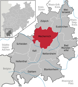
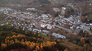
Mechernich is a town in the district of Euskirchen in the south of the state of North Rhine-Westphalia, Germany. It is located in the "Naturpark Nordeifel" in the Eifel hills, approx. 15 km south-west of Euskirchen and 55 km from Cologne. Mechernich is a former mining town and had, in 2009, its 700-years celebration of foundation. Its local football club is called TUS Mechernich.
Dahlem is a municipality in the district of Euskirchen. It has the lowest population density and population of all municipalities of in the state of North Rhine-Westphalia, Germany. It is located in the Eifel hills, approx. 35 km south-west of Euskirchen. The small medieval town Kronenburg is part of the municipality.

Hellenthal is a municipality in the district of Euskirchen in the state of North Rhine-Westphalia, Germany. It is located in the Eifel hills, near the border with Belgium, approx. 30 km south-west of Euskirchen and 40 km south-east of Aachen.

Kall is a municipality in the district of Euskirchen in the state of North Rhine-Westphalia, Germany. It is located in the Eifel hills, approximatively 20 km south-west of Euskirchen.

Nettersheim is a municipality in the district of Euskirchen in the state of North Rhine-Westphalia, Germany. It is located in the Eifel hills, approx. 20 km south-west of Euskirchen. The rivers Erft and Urft have their source in the municipality.
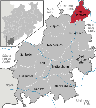
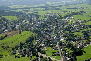
Weilerswist is a municipality in the district of Euskirchen in the state of North Rhine-Westphalia, Germany. It is located in the Eifel hills, approximately 10 kilometers north of Euskirchen, and 20 kilometers south-west of Cologne.

The Swist is a stream, 43.6 kilometres (27.1 mi) long, in the German Rhineland. It rises on the northern edge of the Eifel at 330 metres above sea level and empties from the right and southeast into the Rhine tributary, the Erft, between Weilerswist and Bliesheim. Occasionally the Swist is also called the Swistbach, and locals often just call it der Bach.

Blankenheim Castle is a schloss above the village of Blankenheim in the Eifel mountains of Germany. It was built as a hill castle around 1115 by Gerhard I and became the family seat of the House of Blankenheim. The lords of Blankenheim were elevated to the countship in 1380. The counts were related to the counts of Manderscheid and, from 1469, were named Manderscheid-Blankenheim. With the extinction of the lines of Manderscheid-Gerolstein and Manderscheid-Kail (1742) the County of Manderscheid became the largest independent territorial lordship in the Eifel.
The fortification on the Stromberg near Ripsdorf in the German state of North Rhine-Westphalia is a circular rampart site, which may have been a Celtic refuge fort.
Dollendorf is a village in the municipality of Blankenheim in the district of Euskirchen in the German state of North Rhine-Westphalia. It gives its name to the surrounding limestone depression (Kalkmulde).

Houverath is a village in the town of Bad Münstereifel in the district of Euskirchen, in the German state of North Rhine-Westphalia.


