Dietzenley | |
---|---|
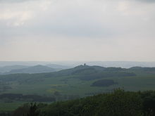
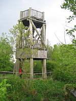
Viewing tower on the Dietzenley | |
Highest point | |
Elevation | 617.6 m above sea level (NHN) (2,026 ft) [1] |
Coordinates | 50°12′09″N6°40′40″E / 50.2025°N 6.67778°E Coordinates: 50°12′09″N6°40′40″E / 50.2025°N 6.67778°E |
Geography | |
Parent range | Volcanic Eifel |
Geology | |
Mountain type | volcano |
Type of rock | Basalt |
The Dietzenley in the county of Vulkaneifel in the German state of Rhineland-Palatinate is a mountain, 617.6 m above sea level (NHN) , [1] and the highest point in the Pelm Forest, a part of the Volcanic Eifel range.
Rhineland-Palatinate is a state of Germany.
Normalhöhennull or NHN is a vertical datum used in Germany.
Pelm is an Ortsgemeinde – a municipality belonging to a Verbandsgemeinde, a kind of collective municipality – in the Vulkaneifel district in Rhineland-Palatinate, Germany. It belongs to the Verbandsgemeinde of Gerolstein, whose seat is in the like-named town.
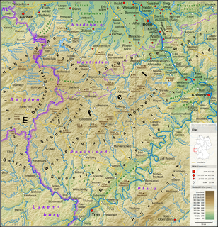
The Dietzenley rises within the Volcanic Eifel Nature Park in the parish of Gerolstein north and above the Gerolstein quarter of Büscheich-Niedereich.
The Volcanic Eifel Nature Park lies in the counties of Bernkastel-Wittlich, Cochem-Zell and Vulkaneifel in the German state of Rhineland-Palatinate. The nature park, which is in the Eifel mountains, and which is also a geopark, was inaugurated on 31 May 2010 and has an area of 1,068.24 km².> Its sponsor is the Natur- und Geopark Vulkaneifel GmbH.
Gerolstein is a town in the Vulkaneifel district of Rhineland-Palatinate, Germany. Gerolstein is a local municipality of the Verbandsgemeinde Gerolstein. It has been approved as a Luftkurort.
On the largely wooded domed summit stands a small, wooden observation tower, which offers a good view of the Volcanic Eifel. Somewhat below it there is an electrical converter and the remains of a Celtic ringwall.
A Kuppe is the term used in German-speaking central Europe for a mountain or hill with a rounded summit that has no rock formation, such as a tor, on it. A range of such hills is called a Kuppengebirge. In geology the term also refers to corresponding stratigraphic forms. The term is similar to the English topographical and geological terms, knoll and dome. It is similar to the French word ballon which means a mountain with a rounded summit.
An observation tower is a structure used to view events from a long distance and to create a full 360 degree range of vision to conduct the long distance observations. They are usually at least 20 metres (66 ft) tall and made from stone, iron, and wood. Many modern towers are also used as TV towers, restaurants, or churches. The towers first appeared in Germany at the end of the 18th century, and their numbers steadily increased, especially after the invention of the lift.
The Celts are an Indo-European ethnolinguistic group of Europe identified by their use of Celtic languages and cultural similarities. The history of pre-Celtic Europe and the exact relationship between ethnic, linguistic and cultural factors in the Celtic world remains uncertain and controversial. The exact geographic spread of the ancient Celts is disputed; in particular, the ways in which the Iron Age inhabitants of Great Britain and Ireland should be regarded as Celts have become a subject of controversy. According to one theory, the common root of the Celtic languages, the Proto-Celtic language, arose in the Late Bronze Age Urnfield culture of Central Europe, which flourished from around 1200 BC.
The Dietzenley may be reached on footpaths from Gerolstein, Pelm or Gees.
The Eifel is a low mountain range in western Germany and eastern Belgium. It occupies parts of southwestern North Rhine-Westphalia, northwestern Rhineland-Palatinate and the south of the German-speaking Community of Belgium.
Vulkaneifel is a district (Kreis) in the northwest of the state Rhineland-Palatinate, Germany. It is the least densely populated district in the state and the fourth most sparsely populated district in Germany. The administrative centre of the district is in Daun. Neighboring districts are Euskirchen, Ahrweiler, Mayen-Koblenz, Cochem-Zell, Bernkastel-Wittlich, and Bitburg-Prüm.
The Kyll, noted by the Roman poet Ausonius as Celbis, is a 128 km long river in western Germany, left tributary of the Moselle. It rises in the Eifel mountains, near the border with Belgium and flows generally south through the towns Stadtkyll, Gerolstein, Kyllburg and east of Bitburg. It flows into the Moselle in Ehrang, a suburb of Trier.
The Salm is a 63-kilometre-long (39 mi) river in western Germany (Rhineland-Palatinate), a left-bank tributary to the river Moselle. It rises in the Eifel, near the village of Salm, south of Gerolstein. The Salm flows generally south, through Großlittgen, Dreis, and Salmtal. It passes west of Wittlich. It empties into the Moselle in Klüsserath.
The Hoher List is a stratovolcano, 549.1 m above sea level (NN), near the town of Daun in the Eifel region. The hill is in the county of Vulkaneifel in the German state of Rhineland-Palatinate.
Berlingen is an Ortsgemeinde – a municipality belonging to a Verbandsgemeinde, a kind of collective municipality – in the Vulkaneifel district in Rhineland-Palatinate, Germany. It belongs to the Verbandsgemeinde of Gerolstein, whose seat is in the like-named town.
Duppach is an Ortsgemeinde, part of a group of municipalities called the Verbandsgemeinde of Gerolstein, which is located in the town of Gerolstein in the Vulkaneifel district of the state of Rhineland-Palatinate, Germany.
Gönnersdorf is an Ortsgemeinde – a municipality belonging to a Verbandsgemeinde, a kind of collective municipality – in the Vulkaneifel district in Rhineland-Palatinate, Germany. It belongs to the Verbandsgemeinde of Gerolstein, whose seat is in the municipality of Gerolstein.
Rockeskyll is an Ortsgemeinde – a municipality belonging to a Verbandsgemeinde, a kind of collective municipality – in the Vulkaneifel district in Rhineland-Palatinate, Germany. It belongs to the Verbandsgemeinde of Gerolstein, whose seat is in the like-named town.
The South Eifel refers to that part of the Eifel mountain region around the Bitburg-Prüm district in the German state of Rhineland-Palatinate.
The Aremberg is, at 623 m above sea level (NN), the highest mountain in the Ahr Hills or Ahr Eifel (Ahreifel). It lies in the district of Ahrweiler, Rhineland-Palatinate (Germany).
The Nerother Kopf is the conical hill of an extinct volcano near Neroth in the Eifel mountains. It is 651.7 m above sea level (NHN) and situated in the county of Vulkaneifel in the German state of Rhineland-Palatinate.
Windsborn Crater Lake is a water-filled volcanic crater in the Eifel mountains in Germany. It is located near Bettenfeld in the county of Bernkastel-Wittlich and in the state of Rhineland-Palatinate, and belongs to a group of four craters known as the Mosenberg Crater Row, named after the village of Mosenberg.
The Apert is a forested mountain, 631.3 m above sea level (NHN), in the western Volcanic Eifel, a mountain range in the German state of Rhineland-Palatinate. It rises about two kilometres south of Büdesheim and is the highest point in the parish (Gemarkung).
The Cross Eifel Railway is a non-electrified railway line between Andernach and Gerolstein in the Eifel in the German state of Rhineland-Palatinate. From Andernach to Mayen Ost (East), it is classified as main line and it has two tracks as far as Mendig.
Gerolstein station is a station on the Eifel Railway in Gerolstein in the German state of Rhineland-Palatinate. Its former function as an important junction station, however, has been lost with the closure of the Cross Eifel Railway (Eifelquerbahn) and the West Eifel Railway (Westeifelbahn). It is the only remaining station in the town.
The Rockeskyller Kopf near Rockeskyll in the county of Vulkaneifel in the German state of Rhineland-Palatinate is a hill, 554.6 m above sea level (NHN), in the Eifel mountains. It is an extinct volcano complex from the Quaternary period, around 360,000 years old and is designated as a natural monument (ND-7233-420).