Krawutschke Tower

Last updated

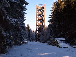
The Krawutschke Tower (German:Krawutschketurm) is a 13 metre tall observation tower in the Hürtgenwald municipality in Germany, about one kilometer east of the village center of Bergstein, approximately 10 km south of Düren. The Krawutschke Tower is 400.5 m above sea level, situated on the Burgberg (Engl. castle mountain), which, during World War II, also had the Allied-given name Hill 400 due to its elevation. The Krawutschke Tower has three platforms, one above the other, each separated by three meters.

Observation tower structure used to view events from a long distance

An observation tower is a structure used to view events from a long distance and to create a full 360 degree range of vision to conduct the long distance observations. They are usually at least 20 metres (66 ft) tall and made from stone, iron, and wood. Many modern towers are also used as TV towers, restaurants, or churches. The towers first appeared in Germany at the end of the 18th century, and their numbers steadily increased, especially after the invention of the lift.

Hürtgenwald Place in North Rhine-Westphalia, Germany

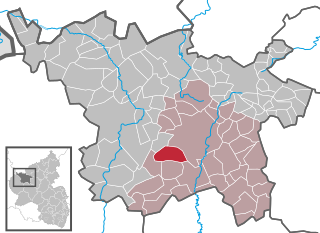
Hürtgenwald is a municipality in the district of Düren in the federal state of North Rhine-Westphalia, Germany. It is located in the Eifel hills, approx. 15 km south-west of Düren. Much of the area is covered by forest.

Germany Federal parliamentary republic in central-western Europe

Germany, officially the Federal Republic of Germany, is a country in Central and Western Europe, lying between the Baltic and North Seas to the north, and the Alps to the south. It borders Denmark to the north, Poland and the Czech Republic to the east, Austria and Switzerland to the south, France to the southwest, and Luxembourg, Belgium and the Netherlands to the west.

View from the South-East Krawutschketurm.jpg
View from the South-East

On a clear day, one can see Cologne cathedral. Looking eastward, the Nideggen Castle is visible on the other side of the Rur valley. The tower has a panoramic view over the reservoir with the dam at Obermaubach.

Cologne Cathedral Church in Cologne, Germany

Cologne Cathedral is a Catholic cathedral in Cologne, North Rhine-Westphalia, Germany. It is the seat of the Archbishop of Cologne and of the administration of the Archdiocese of Cologne. It is a renowned monument of German Catholicism and Gothic architecture and was declared a World Heritage Site in 1996. It is Germany's most visited landmark, attracting an average of 20,000 people a day, and currently the tallest twin-spired church at 157 m (515 ft) tall.

Nideggen Castle castle

The ruins of Nideggen Castle are a symbol of the town of Nideggen in Germany and are owned by the county of Düren. The rectangular hill castle was the seat of the powerful counts and dukes of Jülich and had a reputation in the Middle Ages of being impregnable.

Rur river in Germany and the Netherlands

The Rur or Roer is a major river that flows through portions of Belgium, Germany and the Netherlands. It is a right (eastern) tributary to the Meuse. About 90 percent of the river's course is in Germany.

In 1911 an observation tower was built on the ruins of the former Berenstein castle, the medieval name Berenstein eventually becoming today's Bergstein. In 1933 a new tower was erected, named Eifelwanderer Franz Krawutschke after the locally famous Eifel Club member, Franz Krawutschke (1862-1940). The tower, which also was being used as a fire lookout tower, was heavily damaged during World War II and then destroyed by a forest fire in 1945. It was rebuilt in 1972, financed by the municipality of Hürtgenwald, the Eifel Club, the district of Düren and the state of North Rhine-Westphalia.

Eifel Club

The Eifel Club is one of the largest rambling clubs in Germany with a membership of 28.000. Its purpose is the "maintenance of local customs, the protection and care of monuments to which it is particularly committed".

Fire lookout tower building to house a person who watches for wildfires

A fire lookout tower, fire tower or lookout tower, provides housing and protection for a person known as a "fire lookout" whose duty it is to search for wildfires in the wilderness. The fire lookout tower is a small building, usually located on the summit of a mountain or other high vantage point, in order to maximize the viewing distance and range, known as view shed. From this vantage point the fire lookout can see smoke that may develop, determine the location by using a device known as an Osborne Fire Finder, and call fire suppression personnel to the fire. Lookouts also report weather changes and plot the location of lightning strikes during storms. The location of the strike is monitored for a period of days after in case of ignition.

North Rhine-Westphalia State in Germany

North Rhine-Westphalia is a state of Germany.

From July 2005 to November 2006 the tower had to be closed for safety reasons. After renovation of a substantial part of the supporting wooden construction (costs about € 65,000), the tower is open to the public again.

Related Research Articles

Vulkaneifel is a district (Kreis) in the northwest of the state Rhineland-Palatinate, Germany. It is the least densely populated district in the state and the fourth most sparsely populated district in Germany. The administrative centre of the district is in Daun. Neighboring districts are Euskirchen, Ahrweiler, Mayen-Koblenz, Cochem-Zell, Bernkastel-Wittlich, and Bitburg-Prüm.

Düren Place in North Rhine-Westphalia, Germany

Düren is a town in North Rhine-Westphalia, Germany, between Aachen and Cologne on the river Rur.

Hill 400, Bergstein mountain

Hill 400 is the name given by Allied forces during World War II to a 400.8 metres (1,315 ft) high hill located 1 kilometre (0.62 mi) east of the centre of Bergstein, a village in the Eifel region of Germany.

275th Infantry Division (Wehrmacht) German Army division in World War II

275th Infantry Division

Heimbach Place in North Rhine-Westphalia, Germany

Heimbach is a town in the district of Düren of the state of North Rhine-Westphalia, Germany. It is located on the river Rur, in the Eifel hills, approx. 20 km south of Düren. Heimbach has the smallest population of any town in North Rhine-Westphalia. The districts of the city are Blens, Düttling, Hasenfeld, Hausen, Hergarten and Vlatten, which prior to 1972 were villages with their own administration. Between Hausen and Hergarten lies the hamlet of Walbig, and between Hasenfeld and Schmidt is the hamlet of Buschfelder Hof, which formerly belonged to Blens.

Oberstadtfeld Place in Rhineland-Palatinate, Germany

Oberstadtfeld is an Ortsgemeinde – a municipality belonging to a Verbandsgemeinde, a kind of collective municipality – in the Vulkaneifel district in Rhineland-Palatinate, Germany. It belongs to the Verbandsgemeinde of Daun, whose seat is in the like-named town.

Steineberg Place in Rhineland-Palatinate, Germany

Steineberg is an Ortsgemeinde – a municipality belonging to a Verbandsgemeinde, a kind of collective municipality – in the Vulkaneifel district in Rhineland-Palatinate, Germany. It belongs to the Verbandsgemeinde of Daun, whose seat is in the like-named town.

Volcanic Eifel region in the Eifel Mountains in Germany, that is defined to a large extent by its volcanic geological history

The Volcanic Eifel or Vulkan Eifel is a region in the Eifel Mountains in Germany, that is defined to a large extent by its volcanic geological history. Characteristic of this volcanic field are its typical explosion crater lakes or maars, and numerous other signs of volcanic activity such as volcanic tuffs, lava streams and volcanic craters like the Laacher See. The Volcanic Eifel is still volcanically active today. One sign of this activity is the escaping gases, for example, in the Laacher See.

Hohe Acht mountain

At 746.9 m above sea level (NHN), the Hohe Acht is the highest mountain in the Eifel mountains of Germany. It is located on the boundary between the districts of Ahrweiler and Mayen-Koblenz in Rhineland-Palatinate.

Lissingen Castle castle

Lissingen Castle is a well-preserved former moated castle dating to the 13th century. It is located on the River Kyll in Gerolstein in the administrative district of Vulkaneifel in Rhineland-Palatinate, Germany. From the outside it appears to be a single unit, but it is a double castle; an estate division in 1559 created the so-called lower castle and upper castle, which continue to have separate owners. Together with Bürresheim and Eltz, it has the distinction among castles in the Eifel of never having been destroyed.

Kermeter ridge in the Eifel National Park, Germany

The Kermeter is an upland region, up to 527.8 m above sea level (NN), which is part of the Rureifel within the North Eifel in the districts of Aachen, Düren and Euskirchen in the southwestern part of the state of North Rhine-Westphalia in Germany.

Idarkopf Tower

Idarkopf Tower, also known as Idarkopf Observation Tower for long, is a wooden German lattice observation tower on the summit of Mt. Idarkopf in the state of Rhineland-Palatinate. The observation tower on the 746 m-high (2,448 ft) mountain of Idarkopf has a total height of 28.50 m (94 ft). Built in 1980, the tower was constructed according to a certain kind of specialized wooden frame and was designed through triangular sketch. Staircases are uncountable because of the vast number of steps. The roof, which contains the observation deck, is considered the highest accessible point in the whole area, providing a unique view of the town nearby.

1944 Hürtgen Forest Museum peace museum in Hürtgen Forest

The 1944 Hürtgen Forest Museum is located in Vossenack, in the municipality of Hürtgenwald in the county of Düren in the German state of North Rhine-Westphalia.

Castle Museum, Nideggen Local history museum in Nideggen

The Castle Museum is located in Nideggen Castle in the county of Düren, in the German state of North Rhine-Westphalia.

References

International Standard Book Number Unique numeric book identifier

The International Standard Book Number (ISBN) is a numeric commercial book identifier which is intended to be unique. Publishers purchase ISBNs from an affiliate of the International ISBN Agency.

Coordinates: 50°41′41″N6°26′29″E / 50.69472°N 6.44139°E / 50.69472; 6.44139

Geographic coordinate system Coordinate system

A geographic coordinate system is a coordinate system that enables every location on Earth to be specified by a set of numbers, letters or symbols. The coordinates are often chosen such that one of the numbers represents a vertical position and two or three of the numbers represent a horizontal position; alternatively, a geographic position may be expressed in a combined three-dimensional Cartesian vector. A common choice of coordinates is latitude, longitude and elevation. To specify a location on a plane requires a map projection.