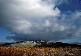
View from the plateau at the Monument of the Wartime Generation of the loop in the Moselle near Stuben Abbey (below) with Ediger-Eller (l), Neef (centre) and Bremm (r)
The Moselle Eifel (German: Moseleifel) forms the southeastern strip of the East Eifel to the left of the Moselle from the city of Trier downstream as far as Moselkern; in the southeast it does not reach as far as the Moselle Valley. It lies exclusively within the German state of Rhineland-Palatinate and is a truncated highland, roughly half of which is forested.
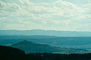
The Moselle Eifel runs in a southwest to northeast direction, northwest along the Moselle river, sometimes away from the river, between Trier-Ehrang, at the confluence of the Kyll and the Moselle, and Moselkern at the confluence of the Elzbach with the same Rhine tributary. The hills of the Moselle Eifel are lower than those of the adjacent and very ancient Volcanic Eifel to the north and only exceed 400mabovesea level (NHN) in a few places, reaching a maximum of 423maboveNHN at Schafstall near Bremm. On the far, southeastern side of the Moselle Valley with its many meanders and well known castles rises the somewhat higher hill range of the Hunsrück.
Natural region grouping
The Moselle Eifel forms a major natural region unit (270) within the major unit group of the East Eifel (no.27) die Haupteinheit Moseleifel (270) and has the BfN no.27001.[1] It is divided as follows:[2][3][4]
291 Middle Rhine Basin (Mittelrheinisches Becken) – northern part of the Moselle Eifel, from Reudelsterz to Moselkern
the direction of and along the Moselle:
250 Middle Moselle Valley (Mittleres Moseltal) – southwest to northwest part of the Moselle Eifel, from Trier-Ehrang to Moselkern
Hills and viewing points
Eltz Castle
The hills and viewing points left of the Moselle Valley include the following (in downstream order) –with heights in metres (m) above sea level (NHN) (unless otherwise stated:[5])
The region is a popular holiday area and part of the Middle Moselle wine growing region. This is characterised by a large number of small, prestigious vineyards that are family-owned. As a result of the relatively steep Moselle Valley the Moselle Wine Road, while the railway only travels along the valley as far as the first river bend at Zell and then ascends the hill upland.
The Bavarian Forest is a wooded, low-mountain region in Bavaria, Germany that is about 100 kilometres long. It runs along the Czech border and is continued on the Czech side by the Bohemian Forest. Most of the Bavarian Forest lies within the province of Lower Bavaria, but the northern part lies within Upper Palatinate. In the south it reaches the border with Upper Austria.
The Holzberg is a small range of hills up to 444.5 m above sea level (NHN) in south Lower Saxony, Germany.
The Leine Uplands is a region in Germany's Central Uplands which forms a part of the Lower Saxon Hills and lies along the River Leine between Göttingen and Hanover. It borders on the Weser Uplands in the west, the Innerste Uplands in the northeast, the Harz in the east and Untereichsfeld in the southeast.
Rassel is a mountain of Hesse, Germany. It lies in the north of the territory of the hessian capital Wiesbaden and is its highest independent elevation.
The Hube is a ridge, up to 346.2 m above sea level (NN), in the Leine Uplands and district of Northeim, in the German state of Lower Saxony.
The Külf is a ridge, up to 260 m above NN, in the Leine Uplands in the district of Hildesheim in the German state of Lower Saxony.
The Hochberg is a 635.3-metre-high mountain in the central Haardt in the Palatine Forest in Germany. It lies on the territory of the municipality of Sankt Martin (Palatinate) in the county of Südliche Weinstraße in the state of Rhineland-Palatinate. After the Kalmit, the Kesselberg and the Roßberg it is the fourth highest peak in the Palatine Forest.
The Central Rhön is a 5th level natural region which, together with the Southern High Rhön, forms the High Rhön. The region has several mountains over 900 metres high, including: the Wasserkuppe (950.0 m) and Heidelstein (926 m). Other summits over 900 metres are regarded as subpeaks due to their low isolation and prominence.
The Wasserkuppen Rhön or Wasserkuppenrhön, named after its highest peak, also the highest summit in the entire Rhön Mountains, the Wasserkuppe, is an exposed highland ridge and natural region in the Hessian county of Fulda and Bavarian county of Rhön-Grabfeld. Together with the Long Rhön and its eastern flank it forms the Central Rhön. The Red Moor lies within this natural region.
The Long Rhön is a ridge in the Central Rhön which forms part of the High Rhön within the Rhön Mountains. The Long Rhön is an elongated basalt plateau in the centre, roughly 800 metres above sea level, which is only occasional interrupted by mountain peaks. Its highest mountain is the Heidelstein. A majority of the area is part of the Long Rhön Nature Reserve. In this area of the Rhön is the Black Moor.
The Rammert is a forested hill range, up to 590 m above sea level (NN), in the Keuper Uplands of central Baden-Württemberg, which belongs to the natural region major unit of Schönbuch and Glemswald in the Swabian Keuper-Lias Land. It continues the Schönbuch to the south(west) and is separated from it by the Tübingen Bay at the Neckar near Tübingen. The majority of the ridge lies in the county of Tübingen, with small elements in the county of Zollernalbkreis.
The Weiselberg is a hill 569.5 m above sea level (NHN) in the North Palatine Uplands near Oberkirchen in the Saarland county of St. Wendel.
The Salzungen Werra Upland is a natural region in Germany that forms part of the East Hesse Highlands in the German states of Hesse and Thuringia.
The Seulingswald is a hill range in the German Central Uplands which reaches heights of up to 480.3 m above sea level (NHN). It is part of the Fulda-Werra Uplands in the East Hesse Highlands within the Hessian county of Hersfeld-Rotenburg; small ridges extend into the Thuringian county of Wartburgkreis. It is a sandstone range and one of the largest contiguous woodland areas in Hesse.
The Middle Rhine Basin is the central landscape region of the Middle Rhine in Germany and, along with the Limburg Basin, forms one of the biggest intra-montane lowland regions within the Rhenish Massif. The basin is divided into the valley bottom of the Neuwied Basin, the Neuwied Basin Perimeter east of the Rhine and the Lower Moselle Valley west of the Rhine in the south, and the Maifeld-Pellenz Hills in the north.
Schöneseiffen is a village southwest of Schleiden in the county of Euskirchen in the German state of North Rhine-Westphalia. The Dieffenbach stream rises north of the village. Schöneseiffen has a population of 433 (2021). Schöneseiffen has sports field, a Bürgerhaus and a youth centre.
The Alarmstange, at 545.2 m above sea level (NHN), is the highest point in the Montabaur Heights, a hill ride on the southwestern edge of the Westerwald. It lies near Horressen in the county of Westerwaldkreis in the German state of Rhineland-Palatinate. Together with the Köppel and the Lippersberg, the Alarmstange forms the centre of the ridge, on which is the largest contiguous woodland area in the Westerwald.
The Köppel, at 540.2 m above sea level (NHN), is the second highest point in the Montabaur Heights, an elongated hill ridge in the Lower Westerwald in Germany. It is second only to the nearby Alarmstange (545.2 m) and lies on the boundary between Montabaur and Dernbach in the county of Westerwaldkreis in the state of Rhineland-Palatinate. At the summit is the Köppel viewing tower.
The Falkensteiner Vorwald is the gently rolling westernmost part of the Bavarian Forest in northern Lower Bavaria and southern Upper Palatinate in the German state of Bavaria.
The White Wall in the Taunus is a quartzite field on the Altkönig that was formed in the ice age as a result of frost weathering. It lies at a maximum elevation of 634 m above sea level (NHN) near Oberursel in the Hessian county of Hochtaunuskreis in Germany.
This page is based on this Wikipedia article Text is available under the CC BY-SA 4.0 license; additional terms may apply. Images, videos and audio are available under their respective licenses.