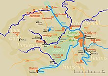
The Eifel is a low mountain range in western Germany, eastern Belgium and northern Luxembourg. It occupies parts of southwestern North Rhine-Westphalia, northwestern Rhineland-Palatinate and the southern area of the German-speaking Community of Belgium.
Mayen-Koblenz is a district (Kreis) in the north of Rhineland-Palatinate, Germany. Neighboring districts are Ahrweiler, Neuwied, Westerwaldkreis, district-free Koblenz, Rhein-Lahn, Rhein-Hunsrück, Cochem-Zell, and Vulkaneifel.

Mayen is a town in the Mayen-Koblenz District of the Rhineland-Palatinate Federal State of Germany, in the eastern part of the Volcanic Eifel Region. As well as the main town, additional settlements include Alzheim, Kürrenberg, Hausen-Betzing, Hausen and Nitztal. Mayen is the administrative centre of the Vordereifel ‘Collective Municipality’, although it is not part of the municipality.

Rhin-et-Moselle was a department of the First French Republic and First French Empire in present-day Germany. It was named after the rivers Rhine and Moselle. It was formed in 1797, when the left bank of the Rhine was annexed by France. Until the French occupation, its territory was divided between the Archbishopric of Cologne, the Archbishopric of Trier, and the Electorate of the Palatinate. Its territory is now part of the German states of Rhineland-Palatinate and North Rhine-Westphalia. Its capital was Koblenz.

Middle Rhine is the section of the Rhine between Bingen and Bonn in Germany. It flows through the Rhine Gorge, a formation created by erosion, which happened at about the same rate as an uplift in the region, leaving the river at about its original level, and the surrounding lands raised. This gorge is quite deep, about 130 metres (430 ft) from the top of the rocks down to the average water-line.

The Leine Uplands is a region in Germany's Central Uplands which forms a part of the Lower Saxon Hills and lies along the River Leine between Göttingen and Hanover. It borders on the Weser Uplands in the west, the Innerste Uplands in the northeast, the Harz in the east and Untereichsfeld in the southeast.

The Haar or Haarstrang is a ridge of hills on the southern edge of the Westphalian Basin in the German state of North Rhine-Westphalia. From a natural region perspective it is the southern, submontane part of the Hellweg Börde, which stands opposite the northern area of the Süder Uplands, north of the Möhne and Ruhr rivers.

The Külf is a ridge, up to 260 m above NN, in the Leine Uplands in the district of Hildesheim in the German state of Lower Saxony.

The Leininger Sporn is a highly prominent ridge in the northeast of the Palatinate Forest in western Germany, mainly composed of the rock formations of the Middle and Upper Bunter. It forms the western edge of Upper Rhine Plain between Grünstadt in the north and Leistadt, a village in the county of Bad Dürkheim, in the southeast. In the natural region system of the German Central Uplands it is considered one of the four sub-units of the Middle Palatinate Forest.

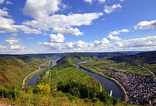
The Lower Moselle is the name given to the lower reaches of the Moselle river - just under 100 kilometres long - in Germany between Pünderich and the Moselle's confluence with the Rhine at Koblenz. The Lower Moselle landscape differs from that of the Middle and Upper Moselle, much of it forming a narrower valley with high and steep sides in places. On the cut banks of the river that are oriented towards the south and west, vineyards are managed, often on the tiniest, terraced strips of land on steep hillslopes.
The Moselle Eifel forms the southeastern strip of the East Eifel to the left of the Moselle from the city of Trier downstream as far as Moselkern; in the southeast it does not reach as far as the Moselle Valley. It lies exclusively within the German state of Rhineland-Palatinate and is a truncated highland, roughly half of which is forested.

The Cross Eifel Railway is a non-electrified railway line between Andernach and Gerolstein in the Eifel in the German state of Rhineland-Palatinate. From Andernach to Mayen Ost (East), it is classified as main line and it has two tracks as far as Mendig.

The Salzungen Werra Upland is a natural region in Germany that forms part of the East Hesse Highlands in the German states of Hesse and Thuringia.

The Maifeld is a landscape of the Middle Rhine Basin on its western perimeter with the Eifel mountains, southwest of the city of Koblenz. It is known for its gently rolling hills.

The Pellenz is a hill country in the northwestern part of the Middle Rhine Basin in Germany between Mayen in the southwest and Andernach in the northeast. In addition Pellenz is the name of a Verbandsgemeinde in the state of Rhineland-Palatinate, which covers the north of the landscape of Pellenz and has had its seat since May 2017 in the village of Plaidt.

The Alarmstange, at 545.2 m above sea level (NHN), is the highest point in the Montabaur Heights, a hill ride on the southwestern edge of the Westerwald. It lies near Horressen in the county of Westerwaldkreis in the German state of Rhineland-Palatinate. Together with the Köppel and the Lippersberg, the Alarmstange forms the centre of the ridge, on which is the largest contiguous woodland area in the Westerwald.
The Köppel, at 540.2 m above sea level (NHN), is the second highest point in the Montabaur Heights, an elongated hill ridge in the Lower Westerwald in Germany. It is second only to the nearby Alarmstange (545.2 m) and lies on the boundary between Montabaur and Dernbach in the county of Westerwaldkreis in the state of Rhineland-Palatinate. At the summit is the Köppel viewing tower.
The Ettringer Bellerberg, also called the Ettringer Bellberg, is a hill, 427.5 m above sea level (NHN), forming the western flank of the Bellerberg Volcano, a volcano system that was active about 200,000 years ago.
The Falkensteiner Vorwald is the gently rolling westernmost part of the Bavarian Forest in northern Lower Bavaria and southern Upper Palatinate in the German state of Bavaria.