Monschau is a small resort town in the Eifel region of western Germany, located in the district Aachen, North Rhine-Westphalia.

The High Fens, which were declared a nature reserve in 1957, are an upland area, a plateau region in the province of Liège, in the east of Belgium and adjoining parts of Germany, between the Ardennes and the Eifel highlands. The High Fens are the largest nature reserve or park in Belgium, with an area of 4,501.2 hectares ; it lies within the German-Belgian natural park Hohes Venn-Eifel, in the Ardennes. Its highest point, at 694 metres (2,277 ft) above sea level, is the Signal de Botrange near Eupen, and also the highest point in Belgium. A tower 6 metres (20 ft) high was built here that reaches 700 metres (2,297 ft) above sea level. The reserve is a rich ecological endowment of Belgium covered with alpine sphagnum raised bogs both on the plateau and in the valley basin; the bogs, which are over 10,000 years old, with their unique subalpine flora, fauna and microclimate, are key to the conservation work of the park.
The German-Belgian High Fens – Eifel Nature Park, often called the North Eifel Nature Park, is a cross-border nature park with elements in the German federal states of North Rhine-Westphalia and Rhineland-Palatinate as well as the Belgian province of Liège. It has a total area of 2,485 km2 (959 sq mi).
The Zitter Forest is located in the Eifel region in the German district of Euskirchen and in the Belgian province of Liège (Wallonia). Its highest point is 692 m above sea level (NN).

The Ahr Hills are a range of low mountains and hills up to 623.8 m above sea level (NHN) and 25 kilometres (16 mi) long in the Eifel region of Germany, which lie roughly southwest of Bonn on the border between the German states of North Rhine-Westphalia and Rhineland-Palatinate.
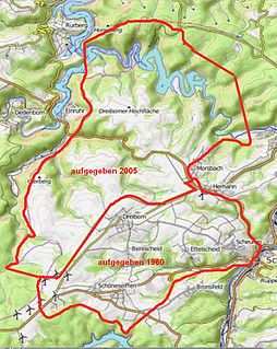
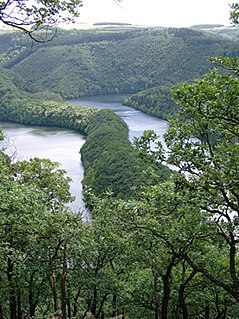
Vogelsang Military Training Area lay in the German North Eifel hills between the villages of Simmerath, Heimbach and Schleiden in the state of North Rhine-Westphalia. It was established in 1946 and handed back at the end of 2005, and consisted of the grounds of the former Nazi leadership training centre in the fort of Vogelsang on the Erpenscheid hill plus additional terrain including the so-called Dreiborn Plateau. In the north and east it was bounded by the Urft Reservoir. The training area had an area of around 45 km2 and since 1 January 2006 has been fully incorporated into the Eifel National Park. Until 1950 the training area was run by the British armed forces and thereafter until 31 December 2005 by the Belgian military.

The Dreiborn Plateau is an area of woods and open terrain, some 33 square kilometres in area, in the Eifel National Park. It corresponds to the area of the Vogelsang Military Training Area which was handed back on 31 December 2005 and had been out-of-bounds to the public since 1 September 1946. Since 2006 parts of the area have been opened up to the public who may use certain routes through it.
The Michelsberg, at 586.1 m above sea level (NHN), is the highest point in the borough of Bad Münstereifel in the county of Euskirchen in the German state of North Rhine-Westphalia. The hill, which rises near the village of Mahlberg belongs to that part of the Eifel mountains known as the Ahr Hills (Ahreifel), and is the second highest point in the range.

The Kalvarienberg is a 523-metre-high (1,716 ft) calvary hill in the nature reserve of Lampertstal near Alendorf, a village in the municipality of Blankenheim in the county of Euskirchen in the German state of North Rhine-Westphalia.

The Hardtkopf is a high hill in the county of Bitburg-Prüm in the German state of Rhineland-Palatinate. It rises in the South Eifel range and, at 601.5 m above sea level (NN), is the highest point on the edge of the Prüm Limestone Basin.

The Herkelstein is a hill, 434.5 m, in the northeastern part of the der Eifel, in the German state of North Rhine-Westphalia. It forms the highest point of the Eschweiler Ridge and lies in the North Eifel Nature Park. Geologically the region is part of the Limestone Eifel, the Herkelstein itself - like the rock formations of the Kakus Caves - is made of Devonian Limestone. It lies between the villages of Weiler am Berge and Holzheim (Mechernich). From the top there is a good long-distance view over the Cologne Bay.

Windsborn Crater Lake is a water-filled volcanic crater in the Eifel mountains in Germany. It is located near Bettenfeld in the county of Bernkastel-Wittlich and in the state of Rhineland-Palatinate, and belongs to a group of four craters known as the Mosenberg Crater Row, named after the village of Mosenberg.

The Dietzenley in the county of Vulkaneifel in the German state of Rhineland-Palatinate is a mountain, 617.6 m above sea level (NHN), and the highest point in the Pelm Forest, a part of the Volcanic Eifel range.

The Wildbretshügel, at 525.3 m above sea level (NHN), is the third highest hill in the Kermeter, an upland region which is part of the Northern Eifel. It is located near Gemünd and Hasenfeld in the counties of Euskirchen and Düren in the German state of North Rhine-Westphalia.

Wolfgarten is a village in the north of the borough of Schleiden in the Eifel mountains in the county of Euskirchen in the German state of North Rhine-Westphalia. The village has a population of about 210.

The Häuschen is a hill, 506.5 m above sea level (NHN), in the Eifel mountains. It rises near Ahrweiler in the county of Ahrweiler in the German state of Rhineland-Palatinate.