
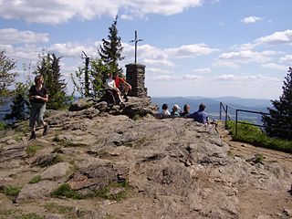
View of the Vogelsang
The Anterior Bavarian Forest (German : Vorderer Bayerischer Wald), also variously called the Vorderer Forest, Vorderer Wald or Danube Hills, is part of the Bavarian Forest, a low mountain range in Germany.
The Anterior Bavarian Forest (German : Vorderer Bayerischer Wald), also variously called the Vorderer Forest, Vorderer Wald or Danube Hills, is part of the Bavarian Forest, a low mountain range in Germany.
In older geographical-regional literature the German name Vordere Bayerische Wald was applied to the whole southern chain of the Bavarian/Bohemian mountains between the Danube and the Regen, from the Keilberg Depression near Regensburg to the Austro-German border near Passau. Bernhard Grueber and Adalbert Müller described it in 1846 as the äußern Wald ('outer forest') "named the Regen Mountains by the geographers". [1] Others chose the name Danube Hills (Donaugebirge) instead.
Frequently this region was even equated with the Bavarian Forest and contrasted with the Bohemian Forest. Beer, in his work Der Böhmerwald und Bayerische Wald in 1925, talked of a "major prelude to the Bohemian Forest“. [2] Even today, many maps only label the lower forest as the Bavarian Forest. [3]
In 1951, the Bavarian Office of Regional Studies (Amt für Landeskunde) described this region as the Anterior Bavarian Forest (Vorderer Bayerische Wald) and gave its central highlands the name High Bavarian Forest (Hoher Bayerischer Vorwald). [4] As part of the regional division of Germany the term Anterior Bavarian Forest was even exclusively restricted to this area which covered 376 km², which only covered the higher parts of the Vorderer Forest. It became major unit 405 in the natural region major unit group, the Upper Palatine-Bavarian Forest (40).
English sources variously use the names Vorderer Forest, [5] Danube Hills, [5] [6] Vorderer Wald, [6] or Anterior Bavarian Forest. [7]
Regardless of this, the part designated as the Falkensteiner Vorwald in regional studies is also called the Vorderer Bayerischer Wald in German sources used for tourism purposes. [8] However, the following description is based on the regional structure.
The natural region of the Danube Hills is only 8 kilometres wide on average. It runs in the typical Hercynian direction from southeast to northwest between the Danube water gap (Donaurandbruch) in the south and the Pfahl in the north.
The low mountain range consists mainly of granitised gneisses and reaches heights of over one thousand metres. Its highest point is the Einödriegel at 1,121 metres. Other important mountains are the Pröller, Hirschenstein, Vogelsang, Dreitannenriegel, Breitenauriegel, Geißkopf and Brotjacklriegel.
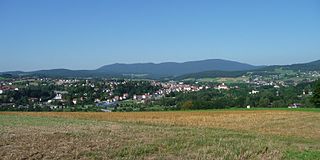
The mountainous region is dominated by woods as well as agriculture and forestry. At the foot of the Pröller lies the winter sports resort of Sankt Englmar. Kalteck, near Langfurth and the Geißkopf and Einödriegel are also important for winter sports. The region is administered by the municipalities of Gotteszell, Grafling, Schöfweg and Zenting. On the Rusel the state road S 2135 crosses the range, whilst the B 11, which originally ran over the Rusel, now bypasses this pass and follows the Bavarian Forest Railway along the Bogenbach. The railway line crosses the Danube Hills at Gotteszell, but needs the 569-metre-long Hochbühl Tunnel to do so.

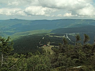
The Bavarian Forest is a wooded, low-mountain region in Bavaria, Germany that is about 100 kilometres long. It runs along the Czech border and is continued on the Czech side by the Bohemian Forest. Most of the Bavarian Forest lies within the province of Lower Bavaria, but the northern part lies within Upper Palatinate. In the south it reaches the border with Upper Austria.

The Bavarian Forest National Park is a national park in the Eastern Bavarian Forest immediately on Germany's border with the Czech Republic. It was founded on 7 October 1970 as the first national park in Germany. Since its expansion on 1 August 1997 it has covered an area of 24,250 hectares. Together with the neighbouring Czech Bohemian Forest the Bavarian Forest forms the largest contiguous area of forest in Central Europe.

The Bohemian Forest, known in Czech as Šumava and in German as Böhmerwald, is a low mountain range in Central Europe. Geographically, the mountains extend from Plzeň Region and the South Bohemian Region in the Czech Republic to Austria and Bavaria in Germany, and form the highest truncated uplands of the Bohemian Massif, up to 50 km wide. They create a natural border between the Czech Republic on one side and Austria and Germany on the other.

Zwiesel is a town in the lower-Bavarian district of Regen, and since 1972 is a Luftkurort with particularly good air. The name of the town was derived from the Bavarian word stem zwisl which refers to the form of a fork. The fork of the rivers Großer Regen and Kleiner Regen and the land that lies between these two rivers were called Zwiesel.
The Großer Arber ; Czech: Velký Javor, "Great Maple") or Great Arber, is the highest peak of the Bavarian/Bohemian Forest mountain range and in Lower Bavaria, with an elevation of 1,455.5 metres (4,775 ft). As a result, it is known in the Lower Bavarian county of Regen and the Upper Palatine county of Cham as the "King of the Bavarian Forest". Its summit region consists of paragneiss.

Altenthann is a village and municipality in the district of Regensburg in Bavaria in Germany.

Lindberg is a municipality in the district of Regen in Bavaria in Germany in the immediate neighbourhood of the larger town Zwiesel.

Obernzell is a municipality in the district of Passau in Bavaria in Germany.

The Bavarian Forest Railway links the heart of the Bavarian Forest around Regen and Zwiesel to Plattling and the Danube valley on one side, and the Czech Republic through Bayerisch Eisenstein on the other. In the Danube valley it forms a junction with the Nuremberg–Regensburg–Passau long-distance railway and, to the south, regional lines to Landshut and Munich.
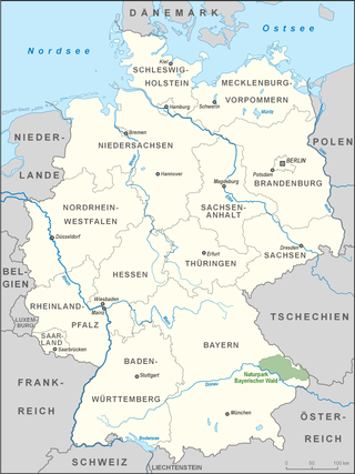
The Upper Palatine-Bavarian Forest, is a natural region in Germany in the northeast of Bavaria. It mainly comprises the low mountain ranges of the Bavarian Forest and Upper Palatine Forest which are up to 1456 m high and border on the Bohemian Massif immediately inside the Czech Republic's southwestern border with Germany.

The Breitenauriegel is a mountain in the Bavarian Forest of Germany.

The Dreitannenriegel is a mountain, 1,090.2 m above sea level (NHN), in the Bavarian Forest.

The Einödriegel is a mountain, 1,120.6 m above sea level (NHN), in the Bavarian Forest in Germany. It rises southwest of the Lower Bavarian county town of Regen and northeast of the county town of Deggendorf. It is the highest point in the Danube Hills and the county of Deggendorf and lies in the municipality of Grafling.
The Großer Falkenstein or Great Falkenstein, is a mountain, 1,315 metres (4,314 ft) high, in the Bavarian Forest about five kilometres southeast of Bayerisch Eisenstein in the Falkenstein-Rachel region of the Bavarian Forest National Park.
The 1,043-metre-high Geißriegel is a mountain in the Danube Hills, the anterior part of the Bavarian Forest, southwest of the Lower Bavarian county town of Regen and northeast of the county town of Deggendorf. It lies within the municipality of Grafling in the county of Deggendorf.
The Hohe Bogen is a roughly 8-kilometre-long mountain ridge in the Bavarian Forest.
The Bavarian Forest Nature Park covers an area north of the Danube as far as the border ridge with the Czech Republic. Its sponsor organisation is the Naturpark Bayerischer Wald whose head office is in Zwiesel, Bavaria. It was established in 1967 and is thus the oldest nature park in Bavaria.

The Neuburg Forest is a largely forested hill ridge and natural region in Lower Bavaria in the county of Passau and the borough of Passau. It is named after the village of Neuburg am Inn.
The Kunisch Mountains is a range that includes part of the Bavarian Forest and the central Bohemian Forest, with its main chain between the Osser and the Zwercheck close to Upper Palatinate. From a geological perspective the Kunisch Mountains occupy a special position, because they are made of mica schist instead of the gneisses and granites that are common elsewhere in the Bavarian Forest. It has good farming soils and heavy precipitation which often falls as snow and ice in winter.
The Falkensteiner Vorwald is the gently rolling westernmost part of the Bavarian Forest in northern Lower Bavaria and southern Upper Palatinate in the German state of Bavaria.
| International | |
|---|---|
| National | |
