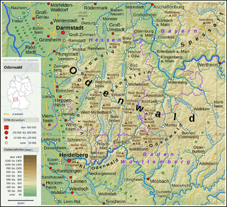
The Odenwald is a low mountain range in the German states of Hesse, Bavaria and Baden-Württemberg.
Neckar-Odenwald-Kreis is a Landkreis (district) in the north of Baden-Württemberg, Germany. Neighboring districts are Main-Tauber-Kreis, Hohenlohe-Kreis, Heilbronn, Rhein-Neckar-Kreis, Odenwaldkreis (Hesse) and Landkreis Miltenberg (Bavaria). The district is part of the Rhine-Neckar Metropolitan Region.

In topography, prominence measures the height of a mountain or hill's summit relative to the lowest contour line encircling it but containing no higher summit within it. It is a measure of the independence of a summit. A peak's key col is a unique point on this contour line and the parent peak is some higher mountain, selected according to various criteria.

Torreys Peak is a mountain in the Front Range region of the Rocky Mountains in Colorado. It is one of 53 fourteeners in Colorado. Its nearest major city is Denver. Torreys Peak is located along the Continental Divide, as well as the division between Clear Creek County and Summit County.

Mount Tamalpais State Park is a California state park, located in Marin County, California. The primary feature of the park is the 2,571 feet (784 m) Mount Tamalpais. The park contains mostly redwood and oak forests. The mountain itself covers around 25,000 acres (100 km2). There are about 60 miles (97 km) of hiking trails, which are connected to a larger, 200 miles (320 km) network of trails in neighboring public lands. The park received 564,000 visitors in as of 2003. Muir Woods National Monument is surrounded by the state park.

Cerro de Punta or just Cerro Punta is the highest peak in Puerto Rico, rising to 1,338 meters (4,390 ft) above sea level. The mountain is part of the Cordillera Central and is located in the municipality of Ponce.

Slide Mountain is the highest peak in the Catskill Mountains of the U.S. state of New York. It is located in the town of Shandaken in Ulster County. While the 4,180-foot (1,270 m) contour line on topographic maps is generally accepted as its height, the exact elevation of the summit has never been officially determined by the U.S. Coast and Geodetic Survey, and many informal surveys suggest the mountain may actually top 4,200 feet above sea level.

The Cape Fold Belt is a fold and thrust belt of late Paleozoic age, which affected the sequence of sedimentary rock layers of the Cape Supergroup in the southwestern corner of South Africa. It was originally continuous with the Ventana Mountains near Bahía Blanca in Argentina, the Pensacola Mountains, the Ellsworth Mountains and the Hunter-Bowen orogeny in eastern Australia. The rocks involved are generally sandstones and shales, with the shales persisting in the valley floors while the erosion resistant sandstones form the parallel ranges, the Cape Fold Mountains, which reach a maximum height of 2325 m at Seweweekspoortpiek.
Vanavasi is a Town Panchayat in Mettur Taluka, Salem District, in the Indian state of Tamil Nadu.

Otzberg is a municipality in the district of Darmstadt-Dieburg, located in the Odenwald forest region of Germany. It was founded in 1972 by the merger of six former independent municipalities.

Kaaterskill High Peak is one of the Catskill Mountains, located in the Town of Hunter in Greene County, New York, United States. It was once believed to be the highest peak in the entire range, but its summit, at 3,655 feet in elevation, places it only 23rd among the Catskill High Peaks. It is, however, the fourth most prominent peak in the range. Due to its situation as the easternmost High Peak, its summit is just outside the watersheds of New York City's reservoirs in the region.
Moore's Knob is the highest mountain in the Sauratown Mountains of Stokes County, North Carolina. The Sauratown Mountains are an isolated remnant of the much larger Blue Ridge Mountains far to the west and north. A rugged, deeply eroded range, the Sauras feature dramatic rock cliffs which can be seen for miles. Moore's Knob has an elevation of 2,579 feet above sea level.

Tromborn is a commune in the Moselle department in Grand Est in north-eastern France.

Cadyanda or Kadyanda was a town of ancient Lycia. The site was discovered by Charles Fellows. The decree of Pixodarus now in the British Museum shows that the Lycian name of the town was Xadawãti.
The Whipple Mountains Wilderness is a 76,122-acre (30,805 ha) wilderness administered by the Bureau of Land Management (BLM). Most of the Whipple Mountains are within the wilderness area. It is located in the northeastern Colorado Desert near the Colorado River. Lake Havasu and Lake Havasu City are 25 miles (40 km) to the North. Earp, California and Parker, Arizona are 20 miles (32 km) to the South. The Parker Dam is 8 miles (13 km) due east.

Sapiranga is a city in Brazil in the state of Rio Grande do Sul with a population of roughly 80,000 inhabitants. It is located in an industrial area called "Vale dos Sinos", by the Rio dos Sinos. The town's economy relies heavily on the shoe industry. Other industries are present, but mostly linked to the shoe manufacturing process, such as metallurgic plants in which machinery is built to later be employed in the production of shoes.

Ilaveezhapoonchira is a tourist destination located in Melukavu village in Kottayam district near Kanjar. Ilaveezha Poonchira is surrounded by three enchanting hillocks - Mankunnu, Kodayathoormala and Thonippara. This makes the place ideal for trekking.
The Neckartal-Odenwald Nature Park is one of the largest nature parks in Baden-Württemberg, Germany with a size of 1520 km². In the north, the Bergstraße-Odenwald Nature Park is located in Hesse and Bavaria, some areas in the north of Baden-Württemberg belong to both nature parks. The nature park is run by Naturpark Neckartal-Odenwald e. V., which was founded in Eberbach in 1980.

Freudenbergite is a mineral that is named in honor of Wilhelm Freudenberg, palaeontologist at the University of Tübingen and the University of Göttingen, and curator for mineralogy and geology at the National Collections of Natural History in Karlsruhe. He studied Katzenbuckel rocks.


